Related Research Articles

The Stikine River is a river, historically also the Stickeen River, approximately 610 kilometres (380 mi) long, in northwestern British Columbia in Canada and in southeast Alaska in the United States.

The Liard River of the North American boreal forest flows through Yukon, British Columbia and the Northwest Territories, Canada. Rising in the Saint Cyr Range of the Pelly Mountains in southeastern Yukon, it flows 1,115 kilometres (693 mi) southeast through British Columbia, marking the northern end of the Rocky Mountains and then curving northeast back into Yukon and Northwest Territories, draining into the Mackenzie River at Fort Simpson, Northwest Territories. The river drains approximately 277,100 square kilometres (107,000 sq mi) of boreal forest and muskeg.

The Boundary Ranges, also known in the singular and as the Alaska Boundary Range, are the largest and most northerly subrange of the Coast Mountains. They begin at the Nass River, near the southern end of the Alaska Panhandle in the Canadian province of British Columbia and run to the Kelsall River, near the Chilkoot Pass, beyond which are the Alsek Ranges of the Saint Elias Mountains, and northwards into the Yukon Territory flanking the west side of the Yukon River drainage as far as Champagne Pass, north of which being the Yukon Ranges. To their east are the Skeena Mountains and Stikine Plateau of the Interior Mountains complex that lies northwest of the Interior Plateau; the immediately adjoining subregion of the Stikine Plateau is the Tahltan Highland. To their northeast is the Tagish Highland, which is a subregion of the Yukon Plateau. Both highlands are considered in some descriptions as included in the Coast Mountains. The Alexander Archipelago lies offshore and is entirely within Alaska.
Brocklehurst is a neighbourhood in the western area of Kamloops, British Columbia, Canada. Brocklehurst is bordered by the Thompson River to the south, North Shore to the east, the Kamloops Airport to the west, and the Batchelor hills and Batchelor Heights aka Batchelor Hills to the north. The community is named after Ed Brocklehurst, a local orchardist from England who lived in the area between 1896-1907.

Hoodoo Mountain is a potentially active flat-topped stratovolcano in the Stikine Country of northwestern British Columbia, Canada, located 74 km (46 mi) northeast of Wrangell, Alaska, on the north side of the lower Iskut River and 30 km (19 mi) east of its junction with the Stikine River. It is situated in the Boundary Ranges of the Coast Mountains and existed since the Late Pleistocene stage of the Pleistocene epoch, which began 130,000 years ago and ended 10,000 years ago.
The Lytton First Nation, a First Nations band government, has its headquarters at Lytton in the Fraser Canyon region of the Canadian province of British Columbia. While it is the largest of all Nlaka'pamux bands, unlike all other governments of the Nlaka'pamux (Thompson) people, it is not a member of any of the three Nlaka'pamux tribal councils, which are the Nicola Tribal Association, the Fraser Canyon Indian Administration and the Nlaka'pamux Nation Tribal Council.
The Tŝideldel First Nation is the band government of the Tsi Del Del subgroup of the Tsilhqot'in people, located in the Chilcotin District in the western Central Interior region of the Canadian province of British Columbia. It is a member of the Tsilhqot'in National Government.

The Seton Lake First Nation, a.k.a. the Seton Lake Indian Band, is a First Nations government located in the Central Interior-Fraser Canyon region of the Canadian province of British Columbia. It is a member of the Lillooet Tribal Council, which is the largest grouping of band governments of the St'at'imc people. Other St'at'imc governments include the smaller In-SHUCK-ch Nation on the lower Lillooet River to the southwest, and the independent N'quatqua First Nation at the farther end of Anderson Lake from Seton Portage, which is the location of three of the band's reserve communities.
The Unuk River is a river in the U.S. state of Alaska and the Canadian province of British Columbia. It flows from the Coast Mountains southwest to Behm Canal, northeast of Ketchikan, Alaska.
The Kingcome Glacier is a glacier located at the head of the Kingcome River in southwestern British Columbia, Canada.
The Porcupine River is a left tributary of the Stikine River in northwestern British Columbia, Canada, entering that stream south of the confluence of the Anuk River and above the confluence of the Iskut.
The Sikanni Range is a subrange of the Omineca Mountains in the Northern Interior of British Columbia, located between the Omineca and Atsika Rivers.
The Blue River is a tributary of the North Thompson River in the South-Central Interior of British Columbia, Canada, located at and being the namesake of the community of the same name, approximately midway between the city of Kamloops and the Yellowhead Pass. The river flows NE to join the North Thompson after flowing generally east from Blue Lake, which is at a low pass with the basin of Murtle Lake and the Murtle River, which join the North Thompson via the Clearwater and the community of the same farther southwest. The Blue River forms part of the boundary between the Shuswap Highland (S) and the southwesternmost Cariboo Mountains (N).

The Iskut River is the largest tributary of the Stikine River in northwestern British Columbia, Canada, entering it a few miles above its entry into Alaska.
The Choquette River is a tributary of the Stikine River, flowing west into that river just north of its confluence with the Iskut. The river is named for Alexander "Buck" Choquette, discoverer of the strike which launched the Stikine Gold Rush and the first non-native settler in the region, who operated a store near here and also for a while the Hudson'a Bay Company post and border station at Stikine, then named Boundary. The Choquette Glacier, at the head of the river and its source, and Mount Choquette are nearby; Mount Johnny in the same region is named for one of Choquette's many sons.
The Twin River is a river in northwestern British Columbia, Canada, located east of Hoodoo Mountain. It flows south into the much larger Iskut River.
The Hoodoo River is a river in northwestern British Columbia, Canada, located west of Hoodoo Mountain and the Twin River. Its drainage is the larger Iskut River.

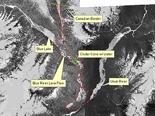
The Volcano, also known as Lava Fork volcano, is a small cinder cone in the Boundary Ranges of the Coast Mountains in northwestern British Columbia, Canada. It is located approximately 60 km (40 mi) northwest of the small community of Stewart near the head of Lava Fork. With a summit elevation of 1,656 m (5,433 ft) and a topographic prominence of 311 m (1,020 ft), it rises above the surrounding rugged landscape on a remote mountain ridge that represents the northern flank of a glaciated U-shaped valley.
The Tsirku Glacier is a large icefield in the Saint Elias Mountains, spanning the border between British Columbia and Alaska, to the south of the Jarvis Glacier. It is the source of the Tsirku River, which flows northwest to become the second-largest tributary of the Chilkat River. GNIS gives its head at 59°17′00″N136°47′00″W and describes it as flowing across the Canada–US border one mile west of the head of the Tsirku River.
The Tasakili River is a tributary of the Stikine River, flowing southeast out of the Boundary Ranges on the United States side of the range to join that river in Canada, just before the Stikine transits the Alaska-British Columbia border.
References
Coordinates: 56°42′00″N131°17′00″W / 56.70000°N 131.28333°W
| | This article about a location in the City and Borough of Wrangell, Alaska is a stub. You can help Wikipedia by expanding it. |