
Hyder is a census-designated place (CDP) in Prince of Wales-Hyder Census Area, Alaska, United States. The population was 87 at the 2010 census, down from 97 in 2000. Hyder is accessible by road from Stewart, British Columbia, and is popular with motorists wishing to visit Alaska without driving the length of the Alaska Highway. It is the southernmost community in the state that can be reached via car. Hyder is Alaska's easternmost town. There are no American border controls at the Hyder–Stewart Border Crossing.
Pearse Island is an island in western British Columbia, Canada, in the Portland Inlet, an inlet of the Pacific Ocean. The island was first charted in 1793 by George Vancouver during his 1791-95 expedition. It was named by George Henry Richards, captain of HMS Plumper, circa 1860, in honour of William Alfred Rombulow Pearse of the Royal Navy, who had been commander of HMS Alert.

Buse Lake Protected Area, informally known as Buse Lake Provincial Park is a provincial park in British Columbia, Canada, 23 km ESE of Kamloops near Monte Creek. It was created in 2000 as part of the outcome of the Kamloops Landuse and Resource Management Plan (KLRMP) and is 228 hectares in size.
Malaspina Provincial Park is a provincial park in British Columbia, Canada, located on the northeast side of the Malaspina Peninsula facing Desolation Sound in the northernmost area of that province's Sunshine Coast region.
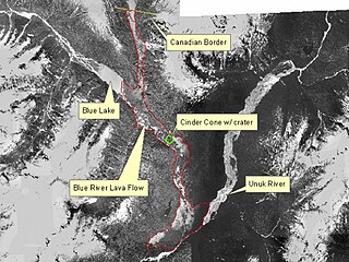
The Unuk River is a river in the U.S. state of Alaska and the Canadian province of British Columbia. It flows from the Coast Mountains southwest to Behm Canal, northeast of Ketchikan, Alaska.

The Monarch Icefield is the northernmost of a series of large continental icecaps studding the heights of the Pacific Ranges of the Coast Mountains in southern British Columbia. Located southeast of the town of Bella Coola and west of the headwaters of the Atnarko River, a tributary of the Bella Coola River, it lies to the north of the Ha-Iltzuk Icefield, which is the largest icefield of the group and home to the Silverthrone volcano. The Monarch Icefield is very remote and is rarely visited by mountaineering parties.

The Kelsall River is a river in the U.S. State of Alaska and the Canadian province of British Columbia. It is a tributary of the Chilkat River, flowing into it in the Haines Borough of Alaska.
The Whitesail Range is a subrange of the Tahtsa Ranges, located north of Whitesail River in northern British Columbia, Canada.
The Tahltan First Nation, also known as the Tahltan Indian Band, is a band government of the Tahltan people. Their main community and reserves are located at Telegraph Creek, British Columbia. Their language is the Tahltan language, which is an Athabaskan language also known as Nahanni, is closely related to Kaska and Dunneza. Their Indian and Northern Affairs Canada band number is 682. The Tahltan First Nation is joined with the Iskut First Nation in a combined tribal council-type organization known as the Tahltan Nation.
The Craig River is a river located in Alaska, United States and British Columbia, Canada, also formerly known as the South Fork of the Iskut River, as it is the main south tributary of the lower Iskut. The Craig has a tributary in Alaska, the South Fork Craig River. The river's origin in Alaska is located near 56°27′00″N131°25′00″W and crosses into British Columbia at 56°29′30″N131°17′30″W.
The Shuswap Indian Reserve is a First Nations reserve in the Columbia Valley region of British Columbia, Canada, located on the left bank of the Columbia River one mile north of Invermere. The reserve is the home reserve of the Shuswap Indian Band, a band government of the Secwepemc (Shuswap) people and a member government of the Shuswap Nation Tribal Council and also of the Ktunaxa Kinbasket Tribal Council in alliance with nearby bands of the Ktunaxa people.
The Tuya River is a major tributary of the Stikine River in far northwestern British Columbia, Canada. Rising at Tuya Lake, which is on the south side of Tuya Mountains Provincial Park, it flows south to meet the Stikine River where that river bisects the Tahltan Highland. Its main tributary is the Little Tuya River.
The extreme points of British Columbia are four in number:
The Leq' a: mel First Nation, formerly known as the Lakahahmen First Nation, is a First Nations band government whose community and offices are located in the area near Deroche, British Columbia, Canada, about 12 kilometres east of the District of Mission. They are a member government of the Sto:lo Nation tribal council, which is one of two tribal councils of the Sto:lo.
South Chilcotin Mountains Provincial Park is a provincial park in British Columbia, Canada, located northwest of Lillooet, British Columbia. The park, which is 56,796 ha. in size, was established in 2010. It was created out of a portion of the Spruce Lake Protected Area.
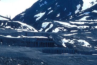
Overlooking the Salmon Glacier, the Granduc Mine is a large copper mine which is situated on a rock ridge between a glacier and a cliff, some 22 miles (35 km) north of Stewart, BC at the north end of Summit Lake. It was an active mine from 1964 to 1984, having closed due to low copper prices.
Kelly Lake is community in the Peace River Country of northeastern British Columbia, Canada, located just west of the border with the province of Alberta.
Coldwater is an Indian reserve community on the Coldwater River in the Nicola Country region of the British Columbia Interior in the Canadian province of British Columbia, located six miles southwest of the City of Merritt. It is the main reserve of the Coldwater First Nation, the government of the local group of Nlaka'pamux people and was the site of the Coldwater Mission, one of the first Catholic missions in the Interior of the province. It was at Coldwater that the Duployan shorthand used in the Kamloops Wawa periodical published by the Kamloops diocese was first learned and taught.
Taleomy Indian Reserve No. 3, officially Taleomy 3, is an Indian reserve under the governance of the Nuxalk Nation, located at the mouth of the Taleomey River on the east shore of South Bentinck Arm in the Central Coast region of British Columbia, Canada.
