
Highway 20, also known as the Chilcotin Highway, and officially dubbed the Alexander MacKenzie Highway, is one of the two main east–west routes in the Central Interior of British Columbia (the other being Highway 16. The Chilcotin Highway runs 457 km from Williams Lake westward through the Chilcotin region to North Bentinck Arm, an inlet from the Pacific Ocean where the town of Bella Coola is located. As of 2019, all but 42 km has been paved, mostly for expediting the removal of timber from the region, which, like most of British Columbia, is afflicted with pine beetle infestations. Logging traffic and ranch-related traffic on the route can be expected.

Bella Coola is an unincorporated community in the Bella Coola Valley of British Columbia, Canada. Bella Coola usually refers to the entire valley, encompassing the settlements of Bella Coola proper, Lower Bella Coola, Hagensborg, Salloompt, Nusatsum, Firvale, and Stuie. It is also the location of the head offices of the Central Coast Regional District.

Monarch Mountain is one of the principal summits of the Pacific Ranges subdivision of the Coast Mountains in southern British Columbia. It stands just east of a pass between the Klinaklini River and the south branch of the Atnarko River, which is a tributary of the Bella Coola River. Surrounding Monarch Mountain is the Monarch Icefield, the northernmost of the major icefields of the Pacific Ranges, and just south of it is the Ha-Iltzuk Icefield, which is the largest. Monarch is in the southern end of Tweedsmuir South Provincial Park.
Dean Channel is the upper end of one of the longest inlets of the British Columbia Coast, 105 km (65.2 mi) from its head at the mouth of the Kimsquit River. The Dean River, one of the main rivers of the Coast Mountains, enters Dean Channel about 9.5 km (5.9 mi) below the head of the inlet, at the community of Kimsquit.
The Bella Coola River is a major river on the Pacific slope of the Coast Mountains in southern British Columbia. The town of Bella Coola is at its mouth on North Bentinck Arm. Bella Coola Indian Reserve No. 1 is the location of the main community today of the surviving population of the Nuxalk who gathered there after depredations by smallpox and colonialization.

Sir Alexander Mackenzie Provincial Park is a provincial park in British Columbia, Canada. Located at the mouth of Elcho Harbour on Dean Channel, it enshrines the farthest point west reached by Alexander Mackenzie in 1793 and the rock he marked to commemorate his journey. The park is also the location of a historical First Nations village, with petroglyphs that can be found along the beach.
Tweedsmuir South Provincial Park is a provincial park covering parts of the eastern Kitimat Ranges, northern Pacific Ranges, and the Rainbow Range in British Columbia, Canada. It was established on May 21, 1938 in the western interior of the province, to protect its important natural features. The park hosts a variety of recreation activities for visitors. This park encompasses a range of diverse species in this park including bears, moose, and various fish. There are also a few at risk species in this park.
Luna Peak is one of the Borealis Peaks in the Coast Mountains of British Columbia, Canada. The Borealis Peaks are located south of the Bella Coola River valley, west of the upper Atnarko River and north of the Monarch Mountain-Ha-Iltzuk Icefield massif. The peak was named for Luna, goddess of the Moon in Roman mythology.

Hagensborg, originally named Kristiania, is a small community in the Bella Coola Valley in British Columbia, Canada. Its census population in 2006 was 248.
The Alexander MacKenzie Heritage Trail is a 420 km (260 mi) long historical overland route between Quesnel and Bella Coola, British Columbia, Canada Of the many grease trails connecting the Coast with the Interior, it is the most notable and often is referred to as the Grease Trail.

The Interior Mountains or Northern Interior Mountains are the semi-official names for an expansive collection of mountain ranges that comprises much of the northern half of the Canadian province of British Columbia and a large area of southern Yukon.

Anahim Peak, also spelled Anaham, ʔAnaghim, or Anaheim, is a volcanic cone in the Anahim Volcanic Belt in British Columbia, Canada, located 39 km (24 mi) northwest of Anahim Lake and 11 km (7 mi) east of Tsitsutl Peak. It was formed when the North American Plate moved over a hotspot, similar to the one feeding the Hawaiian Islands, called the Anahim hotspot. It is one of the several volcanoes in the Anahim Volcanic Belt that stands out all by itself, rising from the Chilcotin Plateau, between the Rainbow Range and the Ilgachuz Range and near the headwaters of the Dean River.

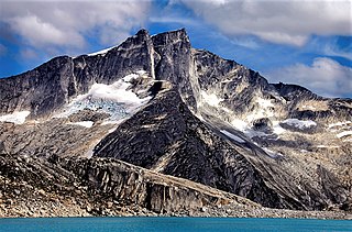
The Monarch Icefield is the northernmost of a series of large continental icecaps studding the heights of the Pacific Ranges of the Coast Mountains in southern British Columbia, Canada. Located southeast of the town of Bella Coola and west of the headwaters of the Atnarko River, a tributary of the Bella Coola River, it lies to the north of the Ha-Iltzuk Icefield, which is the largest icefield of the group and home to the Silverthrone volcano. The Monarch Icefield is very remote and is rarely visited by mountaineering parties.
The Pattullo Range is a subrange of the Hazelton Mountains, located south of Tesla Lake and northeast of Bella Coola in northern British Columbia, Canada. Its highest summit is Tsaydaychuz Peak, 2758 m.
The Edwards Range is a small mountain range near the northern end of the Pacific Ranges of the Coast Mountains of British Columbia, Canada, located north of Gellenspetz Creek and southeast of the town of Bella Coola. It has an area of 179 km2.
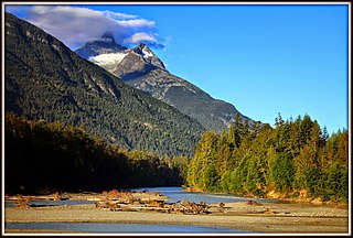
Nusatsum Mountain, is a mountain in the Pacific Ranges of the Coast Mountains of British Columbia, Canada, located near the Nusatsum River and south of and between the communities of Firvale and Hagensborg. The peak can be seen from Highway 20. The mountain is the equivalent of Mount Ararat in the traditions of the Nuxalk, as the place where survivors found refuge from the Great Flood. The landform's toponym was officially adopted March 13, 1947, by the Geographical Names Board of Canada. Other spellings of Nusatsum seen on older maps include "Nootsatsum", "Noosatum" and "Nutsatsum".
Mount Saugstad is a mountain in the northernmost Pacific Ranges of the Coast Mountains in the Central Coast region of British Columbia, Canada. It is located just south of the community of Hagensborg in the Bella Coola Valley and is immediately southeast of Snootli Peak and also southeast of Big Snow Mountain. The Smitley River has its origins on the west side of the summit at the Saugstad Glacier, which is at 52°15′48″N126°31′36″W
Mount Jacobsen, 3,031 m (9,944 ft), is a mountain in the northernmost Pacific Ranges of the Coast Mountains in the Central Coast region of British Columbia, Canada, located to the south of the Bella Coola Valley and immediately south of Ape Lake, to the west of the valley of the Talchako River.
Big Snow Mountain is a 2,357-metre (7,733-foot) mountain summit located in British Columbia, Canada.

Stupendous Mountain is a 2,682-metre (8,799-foot) mountain summit located in British Columbia, Canada.

