
Gannett Peak is the highest mountain peak in the U.S. state of Wyoming at 13,810 feet (4,210 m). It lies in the Wind River Range within the Bridger Wilderness of the Bridger-Teton National Forest. Straddling the Continental Divide along the boundary between Fremont and Sublette counties, it has the second greatest topographic prominence in the state (7076') after Cloud Peak (7077'), and is the highest ground for 290.36 miles in any direction.

Gold River is a village municipality located close to the geographic centre of Vancouver Island in British Columbia, Canada. In terms of the Island's human geography it is considered to be part of the "North Island", even though it technically is on the Island's west coast.

Moldoveanu Peak, at 2,545 metres (8,350 ft), is the highest mountain peak in Romania. It is located in Argeș County, in the Făgăraș Mountains of the Southern Carpathians.

Officially Good Hope Mountain but commonly known as Mount Good Hope is one of the principal summits of the Pacific Ranges of the southern Coast Mountains in British Columbia, Canada. It stands immediately west of Chilko Lake, with the highest peak on the massif rising between the lake's southern arms.

Monmouth Mountain, commonly known as Mount Monmouth is one of the principal summits of the Pacific Ranges of the Coast Mountains of southern British Columbia. At 3,182 m (10,440 ft), it is the highest summit of the Chilcotin Ranges. It stands just north of the Lillooet Icecap between the heads of Chilko Lake and the Taseko Lakes. West of Chilko Lake's south arm is Mount Good Hope 3,242 m (10,636 ft) and, beyond it, the massif surrounding Mount Queen Bess 3,298 m (10,820 ft), which is the highest summit east of the Homathko River.

Crocker Mountain is a 4,228 ft (1,289 m) peak located in Carrabassett Valley, Franklin County, Maine, in the United States. Crocker Mountain is the fourth highest mountain in the state after the Katahdins and Sugarloaf Mountain, and is part of the Appalachian Mountains. Crocker Mountain is traversed by the Appalachian Trail (AT), a 2,170 mi (3,490 km) National Scenic Trail from Georgia to Maine.

Esther Mountain is a mountain located in Essex County, New York. The mountain is the northernmost of the High Peaks of the Adirondack Mountains and its 28th highest peak. It was the only High Peak named for a woman until 2014, having been named in honor of Esther McComb, who made the first recorded climb to the summit in 1839, at age 15; at the time she was attempting to climb Whiteface Mountain from the north.
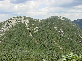
Blake Peak is a mountain located in Essex County, New York. The mountain is named after Mills Blake, Verplanck Colvin’s chief assistant during the Adirondack Survey. It is part of the Colvin Range. Blake Peak is flanked to the northeast by Mount Colvin, and to the southwest by Pinnacle.
Grace Peak is a mountain located in Essex County, New York. It is part of the Dix Range, named after John A. Dix (1798–1879), New York Secretary of State in 1837, and later Governor. The mountain was formerly called East Dix, but in 2014 it was officially renamed Grace Peak in honor of Grace Hudowalski (1906–2004), who in 1937 became the ninth person and first woman to climb all 46 of the Adirondack High Peaks. Grace Peak is flanked to the northeast by Spotted Mountain, and to the southwest by South Dix.

South Dix is a mountain located in Essex County, New York. The mountain is part of the Dix Range, named after John A. Dix (1798–1879), New York Secretary of State in 1837, and later Governor. The name is being changed to Carson Peak, after Russell M.L. Carson (1884–1961), author of Peaks and People of the Adirondacks. South Dix is flanked to the northeast by Grace Peak, to the northwest by Hough Peak, and to the southwest by Macomb Mountain.
Saddleback Mountain is a mountain in the Great Range of the Adirondacks in the U. S. state of New York. It is the 17th highest of the Adirondack High Peaks, with an elevation of 4,515 feet (1,376 m). It is located in Adirondack Park in the town of Keene in Essex County. The mountain was named for the outline of its ridge, which resembles a saddle, by Orson Schofield Phelps and Frederick Perkins. It is flanked by Basin Mountain, the ninth highest of the High Peaks, and Gothics, the tenth highest. Good views of the two higher mountains are offered from the summit of Saddleback. The mountain straddles the watersheds of Johns Brook and the Ausable River. The earliest recorded ascent was made by amateur climber Newell Martin on August 5, 1894. It was claimed that an earlier ascent was made by patent lawyer James J. Storrow and mountain guide Orlando Beede, but the date of this climb is unknown.

Lower Wolfjaw Mountain is located in Essex County, New York, United States. Landscape artist Alexander Helwig Wyant (1836–1892) named Lower Wolfjaw, together with neighboring Upper Wolfjaw Mountain, about 1870 for their appearance in profile. The mountain is the northeasternmost of the Adirondack High Peaks in the Great Range of the Adirondack Mountains. Lower Wolfjaw Mountain is flanked to the southwest by Upper Wolfjaw Mountain, and to the northeast by Hedgehog Mountain.

Donaldson Mountain is a mountain located in Franklin County, New York, named in 1924 after Alfred Lee Donaldson (1866–1923), author of A History of the Adirondacks. The mountain is part of the Seward Mountains of the Adirondacks. Donaldson Mtn. is flanked to the northeast by Seward Mountain, and to the south by Mount Emmons.
The Palo Verde Mountains are a mountain range in northeastern Imperial County, California. They are located along the west side of the Colorado River in the Lower Colorado River Valley and Colorado Desert. Palo Verde Peak, which rises to about 1,800 feet in the southern portion, is the highest point in the area. Thumb Peak stands to the north. Clapp Spring, a palm oasis, is located east of Thumb Peak. Clapp Spring is the only permanent water source in the area for wildlife species.
Howson Peak is a mountain in west central British Columbia, Canada, located 54 km (34 mi) southwest of Telkwa and southwest of the head of Telkwa River. This prominent mountain is the highest of the Howson Range. Howson Peak was first climbed in 1958 after an accident during a 1957 attempt in which Rex Gibson, then president of the Alpine Club of Canada, was killed. That route, as well as many other lines, remains unclimbed. The mountain is now in Tazdli Wiyez Bin or Burnie-Shea Provincial Park. Access is by air to Burnie Lake or on foot from the Kitnayakwa River road. The Burnie Glacier Chalet is the nearest accommodation.
The Battle Range is a subrange of the Selkirk Mountains of the Columbia Mountains in southeastern British Columbia, Canada, located between Incomappleux River and Duncan River south of Battle Brook. It is named in association with Battle Brook which in turn was the site of a legendary battle between a grizzly bear and 1890s prospector George Ritchie.
Mount Ulysses, is the highest mountain in the Muskwa Ranges of the Northern Canadian Rockies in British Columbia. It and neighbouring peaks are part of a group of names drawing on the epic poem The Odyssey, in which here Ulysses wanders for 10 years before being able to return home to Ithaca.

The Florida Mountains are a small 12-mile (19 km) long, mountain range in New Mexico. The mountains lie in southern Luna County about 15 miles (24 km) southeast of Deming, and 20 miles (32 km) north of the state of Chihuahua, Mexico; the range lies in the north of the Chihuahuan Desert region, and extreme southwestern New Mexico.
Black Pine Mountains High Point, at 9,289 feet (2,831 m) above sea level is the highest peak in the Black Pine Mountains of Cassia County in southern Idaho. The high point is sometimes referred to as "Black Peak" because of a benchmark on the peak that reads "Black".

Long Scraggy Peak is a mountain in Jefferson County, Colorado. A prominent peak, it is characterized by its elongated, craggy ridge, for which it is named. The mountain is located within the Pike National Forest near the confluence of the North Fork South Platte River and the South Platte River.
