The Bella Coola River is a major river on the Pacific slope of the Coast Mountains in southern British Columbia. The town of Bella Coola is at its mouth on North Bentinck Arm. Bella Coola Indian Reserve No. 1 the location of the main community today of the surviving population of the Nuxalk who gathered there after depredations by smallpox and colonialization.

North Bentinck Arm is a short inlet about 17 km (10.6 mi) in length in the Central Coast region of British Columbia, Canada. It is an arm of Burke Channel and is linked via that waterway and Labouchere Channel to Dean Channel, which is one of the largest inlets of the BC Coast.

Hagensborg, originally named Kristiania, is a small community in the Bella Coola Valley in British Columbia, Canada. Its census population in 2006 was 248. The valley was already the ancient home to the Nuxálk people when European explorers arrived. Norwegian settlers from Minnesota and Wisconsin arrived in 1894, and the town was named "Hagen's Borg" after Hagen B. Christensen, the first storekeeper in the area and postmaster from April 1, 1896 to October 14, 1910..

The Monarch Icefield is the northernmost of a series of large continental icecaps studding the heights of the Pacific Ranges of the Coast Mountains in southern British Columbia. Located southeast of the town of Bella Coola and west of the headwaters of the Atnarko River, a tributary of the Bella Coola River, it lies to the north of the Ha-Iltzuk Icefield, which is the largest icefield of the group and home to the Silverthrone volcano. The Monarch Icefield is very remote and is rarely visited by mountaineering parties.
Fort McLoughlin was a fur trading post established in 1833 by the Hudson's Bay Company (HBC) on Campbell Island in present-day British Columbia, Canada. At the time the Hudson's Bay Company performed quasi-governmental duties on behalf of the British Empire as well as undertaking trade for profit. The site is believed to have been at McLoughlin Bay on the northeast side of Campbell Island and is associated with the relocation of the Heiltsuk community of Bella Bella from its former location on islets near Denny Island. The McLoughlin name, which is that of John McLoughlin, regional head of company operations at that time, is also found in a lake and a creek entering that bay, and was conferred on these locations after the fort had closed.
The Atnarko River is a river in the Canadian province of British Columbia.
The Pattullo Range is a subrange of the Hazelton Mountains, located south of Tesla Lake and northeast of Bella Coola in northern British Columbia, Canada. Its highest summit is Tsaydaychuz Peak, 2758 m.
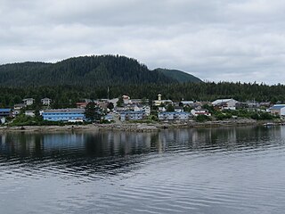
Denny Island is an island on the Central Coast of British Columbia, Canada, just east of the community of Bella Bella, aka Waglisla, on Campbell Island. Denny Island is the location of Old Bella Bella, now mainly abandoned but home to Canadian Coast Guard and Fisheries & Oceans bases, and the locality of Shearwater, home to Shearwater Marine. Denny Island has a population of 138.
Heckman Pass is a mountain pass in the Rainbow Range of west-central British Columbia, Canada, located west of Anahim Lake on the divide between the Chilcotin Plateau and the Bella Coola Valley. It is used by British Columbia Highway 20 and was the route used by Alexander Mackenzie on his journey to the Pacific Coast at Bella Coola via the grease trail along the West Road River from the Fraser.
The Sir Harry Range is a small mountain range in southwestern British Columbia, Canada, located on the west side of Huaskin Lake, between Grappler Sound and Seymour Inlet, north of Port McNeill. It has an area of 18 km2 and is a subrange of the Pacific Ranges which in turn form part of the Coast Mountains. The range was named for Sir Harry Verney whose son, Sir Edmund Verney commanded HMS Grappler while stationed at the Pacific Station from 1862 to 1866.
The New Westminster Land District is one of 59 land districts of British Columbia, Canada, which are the underlying cadastral divisions of that province, created with rest of those on Mainland British Columbia via the Lands Act of the Colony of British Columbia in 1860. The British Columbia government's BC Names system, a subdivision of GeoBC, defines a land district as "a territorial division with legally defined boundaries for administrative purposes" All land titles and surveys use the Land District system as the primary point of reference, and entries in BC Names for placenames and geographical objects are so listed.
Firvale is a community in the Bella Coola Valley of the Central Coast region of British Columbia, Canada, located at the confluence of Burnt Bridge Creek and the Bella Coola River, northeast of the valley's main community of Bella Coola.
The Salloomt River is a river in the Bella Coola Valley of the Central Coast region of British Columbia, Canada. It is a tributary of the Bella Coola River, flowing southwest out of the southernmost Kitimat Ranges to meet that river just upstream from the community of Hagensborg.
The Noosgulch River is a river in the Bella Coola Valley of the Central Coast region of British Columbia, Canada, flowing southwest from the southernmost Kitimat Ranges to meet the Bella Coola River just north of Nusatsum Mountain.
Noohalk Mountain 2099 m is a mountain in the northernmost Pacific Ranges of the Coast Mountains in British Columbia, Canada. It is located on the south side of the Bella Coola Valley between Hagensborg and Bella Coola.
Mount Saugstad is a mountain in the northernmost Pacific Ranges of the Coast Mountains in the Central Coast region of British Columbia, Canada. It is located just south of the community of Hagensborg in the Bella Coola Valley and is immediately southeast of Snootli Peak and also southeast of Big Snow Mountain. The Smitley River has its origins on the west side of the summit at the Saugstad Glacier, which is at 52°15′48″N126°31′36″W
Mount Jacobsen, 3031 m, is a mountain in the northernmost Pacific Ranges of the Coast Mountains in the Central Coast region of British Columbia, Canada, located to the south of the Bella Coola Valley and immediately south of Ape Lake, to the west of the valley of the Talchako River.