Princess Louisa Marine Provincial Park

Last updated
Princess Louisa Marine Provincial Park
Canada Vancouver Island relief map.jpg
Red pog.svg
Canada British Columbia relief location map.jpg
Red pog.svg
Location British Columbia, Canada
Nearest city Powell River
Coordinates 50°12′35″N123°46′36″W / 50.20972°N 123.77667°W / 50.20972; -123.77667
Area9.64 km2 (3.72 sq mi)
EstablishedJune 24, 1965 (1965-06-24)
Governing body BC Parks
Website bcparks.ca/princess-louisa-marine-park/

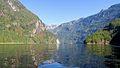
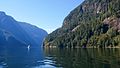
Princess Louisa Marine Provincial Park is a provincial park in British Columbia, Canada surrounding Princess Louisa Inlet. [1] [2] [3]

Contents

See also

Related Research Articles

<span class="mw-page-title-main">Jervis Inlet</span> Inlet in British Columbia, Canada

Jervis Inlet is one of the principal inlets of the British Columbia Coast, about 95 km (59 mi) northwest of Vancouver, and the third of such inlets north of the 49th parallel, the first of which is Burrard Inlet, Vancouver's harbour.

<span class="mw-page-title-main">Princess Royal Island</span>

Princess Royal Island is the largest island on the North Coast of British Columbia, Canada. It is located amongst the isolated inlets and islands east of Hecate Strait on the British Columbia Coast. At 2,251 square kilometres (869 sq mi), it is the fourth largest island in British Columbia. It was named in 1788 by Captain Charles Duncan, after his ship Princess Royal.

<span class="mw-page-title-main">Quatsino Provincial Park</span> Provincial park in British Columbia, Canada

Quatsino Provincial Park is a provincial park in British Columbia, Canada, located on Quatsino Sound on northern Vancouver Island. The park was established July 12, 1995 and is 654 hectares in size. The park is 50 kilometres (31 mi) west of Port Hardy, British Columbia and is accessible by rough logging roads or by boat. Quatsino is on a popular kayaking route.

<span class="mw-page-title-main">Discovery Island Marine Provincial Park</span> Provincial park in British Columbia, Canada

Discovery Island Marine Provincial Park is a provincial park located about two nautical miles east of Oak Bay on the coast of British Columbia, Canada. It is about one mile (1.6 km) long and one-half mile (0.80 km) wide and looks out into the Strait of Juan de Fuca.

Green Inlet Marine Provincial Park is a provincial park in British Columbia, Canada, in the North Coast region to the southeast of Butedale and containing 33 ha.

<span class="mw-page-title-main">Harmony Islands Marine Provincial Park</span> Provincial park in British Columbia, Canada

Harmony Islands Marine Provincial Park is a provincial park in British Columbia, Canada, located on the east side of Hotham Sound, which is a side-inlet of the lower reaches of Jervis Inlet, on that inlet's north side roughly opposite the mouth of Sechelt Inlet.

Háthayim Marine Provincial Park, formerly Von Donop Marine Provincial Park, is a provincial park in British Columbia, Canada, located on the north end of Cortes Island in the Discovery Islands.

<span class="mw-page-title-main">Montague Harbour Marine Provincial Park</span> Provincial park on Galiano Island in British Columbia, Canada

Montague Harbour Marine Provincial Park is a provincial park in British Columbia, Canada, located on Galiano Island, one of the Gulf Islands off BC's South Coast in Canada. It is accessible by BC Ferries from Swartz Bay on Vancouver Island or Tsawwassen on the Mainland. The Island's ferry terminal is at Sturdies Bay, about 6 km (3.7 mi) from Montague.

<span class="mw-page-title-main">Penrose Island Marine Provincial Park</span> Canadian provincial park

Penrose Island Marine Provincial Park is a provincial park in the Central Coast region of British Columbia, Canada, located on the north side of the entrance to Rivers Inlet, 86 km north of Port Hardy at the south end of Fitz Hugh Sound. Comprising 1,079 hectares of marine area and 934 hectares of land area, the park is accessible by boat only and entrance to its anchorages are on its eastern side, the western being exposed to the open ocean. Exploration by dinghy and kayak are popular with visitors, as are nature viewing, scuba diving and exploring the islands many beaches and adjoining islets. The nearest supply centre for fuel and food is at the community of Rivers Inlet.

<span class="mw-page-title-main">Sechelt Inlets Marine Provincial Park</span> Provincial park in British Columbia, Canada

Sechelt Inlets Marine Provincial Park is a provincial park in British Columbia, Canada, that protects six separate sites along three inlets north of the city of Sechelt. The six sites are located at various locations on Sechelt Inlet and its two side arms, Salmon Inlet and Narrows Inlet. Established initially as a recreation area in 1980, it was converted to a park in 1999, consisting of approximately 140 hectares in total.

Small Inlet Marine Provincial Park is a provincial park in British Columbia, Canada on the northwest side of Quadra Island, near the city of Campbell River.

<span class="mw-page-title-main">Smuggler Cove Marine Provincial Park</span> Provincial park of British Columbia, Canada

Smuggler Cove Marine Provincial Park is a provincial park in British Columbia, Canada located approximately 16 kilometres (9.9 mi) west of Sechelt, a city on the Sunshine Coast.

<span class="mw-page-title-main">Princess Louisa Inlet</span>

Princess Louisa Inlet is a fjord on British Columbia’s Sunshine Coast and within the swiya of the shíshálh Nation.

<span class="mw-page-title-main">Victoria Harbour (British Columbia)</span> Port in Canada

Victoria Harbour is a harbour, seaport, and seaplane airport in the Canadian city of Victoria, British Columbia. It serves as a cruise ship and ferry destination for tourists and visitors to the city and Vancouver Island. It is both a port of entry and an airport of entry for general aviation. Historically it was a shipbuilding and commercial fishing centre. While the Inner Harbour is fully within the City of Victoria, separating the city's downtown on its east side from the Victoria West neighbourhood, the Upper Harbour serves as the boundary between the City of Victoria and the district municipality of Esquimalt. The inner reaches are also bordered by the district of Saanich and the town of View Royal. Victoria is a federal "public harbour" as defined by Transport Canada. Several port facilities in the harbour are overseen and developed by the Greater Victoria Harbour Authority, however the harbour master's position is with Transport Canada.

<span class="mw-page-title-main">West Redonda Island</span>

West Redonda Island is an island in British Columbia, Canada. It is part of the Discovery Islands, an archipelago between Vancouver Island and the mainland, and between the Strait of Georgia and Johnstone Strait.

Malibu is a locality in the Canadian province of British Columbia's Sunshine Coast district. This place may also be referred to as Malibu Islet and Malibu Rapids. This was the site of the Malibu Club, formerly a private resort which is today a Young Life camp.

<span class="mw-page-title-main">Chatterbox Falls</span> Waterfall in NE end of Jervis Inlet, New Westminster Land District

Chatterbox Falls is a waterfall in British Columbia, Canada, located at the head or end of Princess Louisa Inlet. It is part of Loquilts River which empties into the inlet. The falls are a popular destination for boaters around the world and are in Princess Louisa Marine Provincial Park, part of BC Parks' marine park system which manages the area with the cooperation of the Princess Louisa International Society.

Musket Island Marine Provincial Park is a provincial park in British Columbia, Canada, located on the west side of Nelson Island, at the mouth of Jervis Inlet and near Earl's Cove in the Sunshine Coast region.

<span class="mw-page-title-main">Salmon Inlet</span>

Salmon Inlet, formerly Salmon Arm, is a fjord branching east from Sechelt Inlet in the British Columbia, Canada. Its companion, Narrows Inlet, another side-inlet of Sechelt Inlet, lies roughly 10 km (6.2 mi) north. Misery and Sechelt Creeks flow freely into the inlet, while the Clowhom River flows in from the artificial Clowhom Lake, formed by a small hydroelectric power development. The fjord is 23 km (14 mi) long; Clowhom Lake, covering a waterfall on the Clowhom River, stretches a further 12 km (7.5 mi) to the western base of Mount Tantalus, which is best known from the direction of Squamish and the Cheakamus Canyon stretch of British Columbia Highway 99. Heavily affected by logging and milling operations, the inlet is split almost into two portions by an alluvial fan spreading from the mouth of Sechelt Creek.

<span class="mw-page-title-main">Narrows Inlet</span>

Narrows Inlet formerly Narrows Arm is a fjord branching east from Sechelt Inlet in British Columbia, Canada. Its companion, Salmon Inlet, another side-inlet of Sechelt Inlet, lies roughly 10 km (6.2 mi) south.

References

  1. "Princess Louisa Marine Park". BC Geographical Names .
  2. BC Parks: Princess Louisa Marine Provincial Park
  3. BritishColumbia.com: Princess Louisa Marine Park

50°12′20″N123°46′13″W / 50.2056°N 123.7703°W / 50.2056; -123.7703