
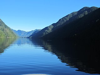
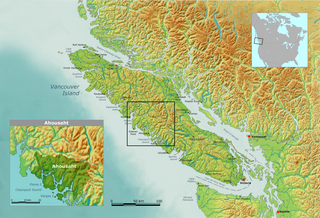
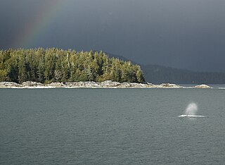
Clayoquot Sound is located on the west coast of Vancouver Island in the Canadian province of British Columbia. It is bordered by the Esowista Peninsula to the south, and the Hesquiaht Peninsula to the North. It is a body of water with many inlets and islands. Major inlets include Sydney Inlet, Shelter Inlet, Herbert Inlet, Bedwell Inlet, Lemmens Inlet, and Tofino Inlet. Major islands include Flores Island, Vargas Island, and Meares Island. The name is also used for the larger region of land around the waterbody.

Pacific Rim National Park Reserve is a 511 km2 (197 sq mi) national park located in British Columbia, Canada, which comprises three separate regions: Long Beach, the Broken Group Islands, and the West Coast Trail. It is located in the Pacific Coast Mountains, which are characterized by rugged coasts and temperate rainforests.

The Nuu-chah-nulth, also formerly referred to as the Nootka, Nutka, Aht, Nuuchahnulth or Tahkaht, are one of the Indigenous peoples of the Pacific Northwest Coast in Canada. The term Nuu-chah-nulth is used to describe fifteen related tribes whose traditional home is on the west coast of Vancouver Island.
Clayoquot is an anglicization of the Nuu-chah-nulth language name "Tla-o-qui-aht", one of the indigenous tribes of the region so named. It may refer to:

The Tla-o-qui-aht First Nations are a Nuu-chah-nulth First Nation in Canada. They live on ten reserves along the Pacific Rim National Park Reserve on Vancouver Island, British Columbia. The band is part of the Nuu-chah-nulth Tribal Council. There were 618 people living in the Tla-o-qui-aht reserves in 1995. Their primary economic activities are fishing and tourism.
The Hesquiaht First Nation is one of the Nuu-chah-nulth Nations, located on west side of Vancouver Island. Approximately 100 people live in Hot Springs Cove, with a commute of over one hour by boat into Tofino. The Hot Springs Cove reserve is located on territory claimed by the Ahousaht First Nation.
Nuu-chah-nulth, a.k.a.Nootka, is a Wakashan language in the Pacific Northwest of North America on the west coast of Vancouver Island, from Barkley Sound to Quatsino Sound in British Columbia by the Nuu-chah-nulth peoples. Nuu-chah-nulth is a Southern Wakashan language related to Nitinaht and Makah.

Vargas Island Provincial Park is a provincial park in British Columbia, Canada, comprising the west side of the island of the same name, which is located west of Meares Island and northwest of the resort community of Tofino in the Clayoquot Sound region of the West Coast of Vancouver Island, British Columbia, Canada. The park was created as part of the Clayoquot Land-Use Decision on July 13, 1995 and contains 5,805 hectares, 1,543 hectares of it being upland and 4,262 hectares being foreshore. Also located on Vargas Island, on its north side, is Epper Passage Provincial Park.
Epper Passage Provincial Park is a provincial park in British Columbia, Canada, located on the north side of Vargas Island in the Clayoquot Sound region of the West Coast of Vancouver Island. Also on Vargas Island is Vargas Island Provincial Park. Other provincial parks nearby are Flores Island Marine Provincial Park, Gibson Marine Provincial Park, Maquinna Marine Provincial Park, Sydney Inlet Provincial Park, Dawley Passage Provincial Park and Hesquiat Peninsula Provincial Park. The park was created as part of the Clayoquot Land-Use Decision on July 13, 1995, and contains approximately 306 ha.

Hesquiat Lake Provincial Park is a provincial park located on the west coast of Vancouver Island in British Columbia, Canada. It was established on April 5, 2001 to mature coastal forests of Western hemlock, western red cedar and lodgepole pine along the eastern shores of Hesquiat Lake.
Sydney Inlet Provincial Park is a provincial park in the Clayoquot Sound region of the west coast of Vancouver Island, British Columbia, Canada, located north of the settlement of Hot Springs Cove and northwest of the resort town of Tofino. Sydney Inlet was the name of the post office in the area from its creation in 1947 to 1948, when it was renamed Hot Springs Cove, though that post office was subsequently closed in 1974.
Kyuquot Sound is a complex of coastal inlets, bays and islands on northwestern Vancouver Island in the Canadian province of British Columbia.
Opitsaht, spelled also as Opitsat and Opitsitah, is a First Nations settlement/community in the Southwest area of the Meares Islands, Clayoquot South, British Columbia. This peninsula-like region is the home to Tla-o-qui-aht First Nations of the Nuu-chah-nulth nation. The Tla-o-qui-aht are an Indigenous group from the Pacific Northwest region in the lower Vancouver area, known for their lifestyle revolving around the marine life trade and culture within the community.
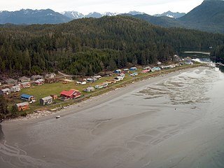
Marktosis, also spelled Maaqtusiis in the Nuu-chah-nulth language, is one of the principal settlements of Ahousaht First Nation, located off the west coast of Vancouver Island in British Columbia, Canada, just southeast of the Hesquiat Peninsula on Flores Island. Accessible only by water or air, Marktosis is a small community predominantly composed of First Nations people from the Nuu-chah-nulth nation. Marktosis has approximately 900 residents.

The Clayoquot protests, also called the War in the Woods, were a series of blockades related to clearcutting in Clayoquot Sound, British Columbia. They culminated in mid-1993, when 856 people were arrested. The blockades in the summer of 1993 against logging of the temperate rainforest were the largest act of civil disobedience in Canadian history until the 2021 Fairy Creek blockades.
The Esowista Peninsula is a peninsula in the Clayoquot Sound region of the west coast of Vancouver Island, British Columbia, Canada. The name was adopted in 1934 in reference to Esowista Indian Reserve No. 3. The name originally applied to the neck of land between Templar Channel and Browning Passage, centred at 49°08′N125°54′W to the whole neck of land from Grice Bay, Long Beach and Tofino. It was originally charted as Low Peninsula by the Royal Navy in 1860. Much of the peninsula is within the Pacific Rim National Park Reserve.
Esowista Indian Reserve No. 3, also known as Esowista 3, is an Indian reserve located on the Esowista Peninsula in the Clayoquot Sound region of the west coast of Vancouver Island, British Columbia, Canada. Located at the head of Wickaninnish Bay, just east of Schooner Cove, it is part of the group of reserves under the governance of the Tla-o-qui-aht First Nations of the Nuu-chah-nulth peoples. Its population in 2006 was 160.
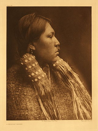
The Hesquiaht are one of the Nuu-chah-nulth peoples of the West Coast of Vancouver Island, British Columbia, Canada. Today the Hesquiaht are governed mostly by the Hesquiaht First Nation band government, though some are in the Tla-O-Qui-Aht First Nations, which also includes the Clayoquot and some of the Ahousaht.
The Hesquiat Peninsula is a peninsula on the West Coast of Vancouver Island, British Columbia, located northwest of the town of Tofino and Clayoquot Sound and Nootka Sound to the northwest. It marks the division between the two regions formed by those sounds and is named for the Hesquiaht people of the Nuu-chah-nulth, and is the location of Hesquiat Peninsula Provincial Park. The Estevan Point lighthouse is at the apex of the peninsula.`
Clayoquot Sound Biosphere Reserve is a UNESCO Biosphere Reserve situated in Clayoquot Sound on the west coast of Vancouver Island in British Columbia, Canada. A diverse range of ecosystems exist within the biosphere reserve boundaries, including temperate coastal rainforest, ocean and rocky coastal shores.


