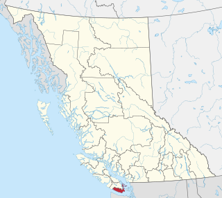
British Columbia is the westernmost province of Canada. Situated in the Pacific Northwest between the Pacific Ocean and the Rocky Mountains, the province has a diverse geography, with rugged landscapes that include rocky coastlines, sandy beaches, forests, lakes, mountains, inland deserts and grassy plains. British Columbia borders the province of Alberta to the east; the territories of Yukon and Northwest Territories to the north; the U.S. states of Washington, Idaho and Montana to the south, and Alaska to the northwest. With an estimated population of over 5.6 million as of 2024, it is Canada's third-most populous province. The capital of British Columbia is Victoria, while the province's largest city is Vancouver. Vancouver and its suburbs together make up the third-largest metropolitan area in Canada, with the 2021 census recording 2.6 million people in Metro Vancouver. British Columbia is Canada's third-largest province in terms of total area, after Quebec and Ontario.

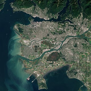
Vancouver is a major city in Western Canada, located in the Lower Mainland region of British Columbia. As the most populous city in the province, the 2021 Canadian census recorded 662,248 people in the city, up from 631,486 in 2016. The Metro Vancouver area had a population of 2.6 million in 2021, making it the third-largest metropolitan area in Canada. Greater Vancouver, along with the Fraser Valley, comprises the Lower Mainland with a regional population of over 3 million. Vancouver has the highest population density in Canada, with over 5,700 inhabitants per square kilometre (15,000/sq mi), and the fourth highest in North America.

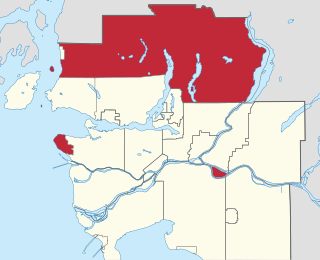
Richmond is a city in the coastal Lower Mainland region of British Columbia, Canada. Mainly a suburban city, it occupies almost the entirety of Lulu Island, between the two estuarine distributaries of the Fraser River. Encompassing the adjacent Sea Island and several other smaller islands and uninhabited islets to its north and south, the suburb neighbours Vancouver and Burnaby on the Burrard Peninsula to the north, New Westminster and Annacis Island to the east, Delta to the south, and the Strait of Georgia to the west.
The Metro Vancouver Regional District (MVRD), or simply Metro Vancouver, is a Canadian political subdivision and corporate entity representing the metropolitan area of Greater Vancouver, designated by provincial legislation as one of the 28 regional districts in British Columbia. The organization was known as the Regional District of Fraser–Burrard for nearly one year upon incorporating in 1967, and as the Greater Vancouver Regional District (GVRD) from 1968 to 2017.
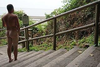
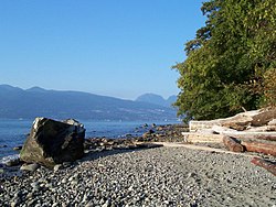
Wreck Beach is a nude beach located in Pacific Spirit Regional Park, a part of Electoral Area A just west of Vancouver, British Columbia, Canada. The clothing-optional section is clearly marked with signs and stretches about 6.7 kilometres or 4.2 miles from Acadia Beach, in the north, to the Booming Grounds Creek on the north arm of the Fraser River. The park is administered by Metro Vancouver, though Indigenous claims are repeatedly asserted, especially by the Musqueam Nation.

Coquitlam is a city in the Lower Mainland of British Columbia, Canada. Mainly suburban, Coquitlam is the sixth-largest city in the province, with a population of 148,625 in 2021, and one of the 21 municipalities comprising Metro Vancouver. The mayor is Richard Stewart.
The Capital Regional District (CRD) is a local government administrative district encompassing the southern tip of Vancouver Island and the southern Gulf Islands in the Canadian province of British Columbia. The CRD is one of several regional districts in British Columbia and had an official population of 415,451 as of the Canada 2021 Census.

The Burrard Peninsula is a peninsula in the Lower Mainland region of British Columbia, Canada, bounded by the Burrard Inlet to the north, the Georgia Strait to the west, the North Arm of Fraser River to the south, and the Pitt River and Douglas Island to the east. The City of Vancouver occupies almost all of the western half of the peninsula, and the Cities of Burnaby and New Westminster occupy more than half of the eastern half. At its northeastern end, the peninsula is connected to the Eagle Mountain and Mount Burke of the Coast Mountains via a small isthmus at the center of the Tri-Cities.

Greater Vancouver, also known as Metro Vancouver, is the metropolitan area with its major urban centre being the city of Vancouver, British Columbia, Canada. The term "Greater Vancouver" describes an area that is roughly coterminous with the region governed by the Metro Vancouver Regional District (MVRD), though it predates the 1966 creation of the regional district. It is often used to include areas beyond the boundaries of the regional district but does not generally include wilderness and agricultural areas that are included within the MVRD.

The Fraser Valley Regional District (FVRD) is a regional district in British Columbia, Canada. Its headquarters are in the city of Chilliwack. The FVRD covers an area of 13,361.74 km2 (5,159 sq mi). It was created in 1995 by an amalgamation of the Fraser-Cheam Regional District and Central Fraser Valley Regional District and the portion of the Dewdney-Alouette Regional District from and including the District of Mission eastwards.

Burns Bog is an ombrotrophic peat bog located in Delta, British Columbia, Canada. It is the largest raised peat bog and the largest undeveloped urban land mass on the West Coast of the Americas. Burns Bog was originally 4,000–4,900 hectares before development. Currently, only 3,500 hectares remain of the bog.
Metro Vancouver Electoral Area A is a part of Metro Vancouver in British Columbia. It includes several unincorporated areas: the University Endowment Lands and the University of British Columbia, west of the City of Vancouver; Bowyer, Passage, and Barnston Islands; the west side of Pitt Lake; the northern portion of Indian Arm; and a large area to the north of the North Shore that is mostly mountainous and sparsely populated except for certain subdivisions between Horseshoe Bay and the Village of Lions Bay.

Iona Island in Richmond, British Columbia, Canada was formerly an island, but is now a peninsula physically connected to Sea Island via a causeway and Ferguson Road. Iona is home to a primary sewage treatment plant, an animal refuge and a park. The Iona Sewage Plant is located near the centre of the island and has tours for the public. Iona Beach Regional Park also features a beach adjacent to wildlife from the nearby animal refuge. The park is managed by Metro Vancouver. Iona Island is located almost adjacent to the Vancouver International Airport. The park is mostly visited by birders, as the sewage ponds have attracted many rare shorebirds such as Spoon-billed Sandpiper, Great Knot, and Red-necked Stint.

Dunbar–Southlands is a neighbourhood situated on the western side of Vancouver, British Columbia, Canada, that stretches north from the Fraser River and covers most of the land between the mouth of the Fraser and English Bay.

təmtəmíxʷtən/Belcarra Regional Park is a 1,100-hectare (2,700-acre) regional park located in Belcarra, Greater Vancouver, British Columbia. It is northeast of the meeting of Burrard Inlet with Indian Arm, beginning near Belcarra Bay and extending to Sasamat Lake. The park is northwest of the Village of Anmore and to the southwest of Buntzen Lake. Apart of its 1,104 hectares, are the 92 hectares of Admiralty Point Lands, ocean waterfront lands in Port Moody.

Kanaka Creek Regional Park is a regional park of the Greater Vancouver Regional District, located in the city of Maple Ridge, British Columbia, flanking both sides of Kanaka Creek from its confluence with the Fraser River just east of Haney and extending approximately 11 km up the creek to just south of the community of Webster's Corners. The Maple Ridge Fairgrounds are just east of the lower regions of the park, beyond them is the community of Albion. Derby Reach Regional Park is just across the Fraser in Langley.

The University Endowment Lands (UEL) is an unincorporated area in Metro Vancouver, British Columbia, Canada. It lies west of Vancouver and east of the University of British Columbia's Point Grey campus lands. Most of the University Endowment Lands' land area is occupied by Pacific Spirit Regional Park, a large nature park operated by Metro Vancouver, with the remainder consisting of residential and commercial developments.

The Maplewood Flats Conservation Area is a 126 hectare conservation area located in North Vancouver, British Columbia, Canada. The area is composed of a 96 hectare intertidal zone of mudflats and salt marsh, and a 30 hectare upland area. It is preserved by Port Metro Vancouver as one of their ecological land initiatives. The land is located approximately 2 km east of the Second Narrows Bridge along Burrard Inlet in North Vancouver.

University of British Columbia Vancouver, officially known as the Point Grey campus lands, is an unincorporated area that contains the main campus of the University of British Columbia in Metro Vancouver, British Columbia, Canada. Located at the western tip of the Point Grey Peninsula, UBC Vancouver is bordered only by the University Endowment Lands, which separate the campus from the City of Vancouver.
Marine Drive is the name for three major roadways in Greater Vancouver, British Columbia, Canada. The roads are known for running parallel to major bodies of water, with some sections being a major arterial road, while other serve local traffic. Marine Way is the name applied to a section of Marine Drive that was bypassed in the early 1980s.