
The Kettle Valley Railway was a subsidiary of the Canadian Pacific Railway (CPR) that operated across southern British Columbia, west of Midway running to Rock Creek, then north to Myra Canyon, down to Penticton over to Princeton, Coalmont, Brookmere, Coquihalla and finally Hope where it connected to the main CPR line.

Hope is a district municipality at the confluence of the Fraser and Coquihalla rivers in the province of British Columbia, Canada. Hope is at the eastern end of both the Fraser Valley and the Lower Mainland region, and is at the southern end of the Fraser Canyon. To the east, over the Cascade Mountains, is the Interior region, beginning with the Similkameen Country on the farther side of the Allison Pass in Manning Park. Located 154 kilometres (96 mi) east of Vancouver, Hope is at the southern terminus of the Coquihalla Highway and the western terminus of the Crowsnest Highway, locally known as the Hope-Princeton, where they merge with the Trans-Canada Highway. Hope is at the eastern terminus of Highway 7. As it lies at the eastern end of the Fraser Valley in the windward Cascade foothills, the town gets very high amounts of rain and cloud cover – particularly throughout the autumn and winter.
Spuzzum is an unincorporated community in the lower Fraser Canyon area of southwestern British Columbia, Canada. The place is on the west shore of the Fraser River and north shore of Spuzzum Creek. The locality, on BC Highway 1, is by road about 40 kilometres (25 mi) north of Hope and 69 kilometres (43 mi) south of Lytton.
Princeton is a town municipality in the Similkameen region of southern British Columbia, Canada. The former mining and railway hub lies at the confluence of the Tulameen into the Similkameen River, just east of the Cascade Mountains. At the junction of BC Highway 3 and 5A, the locality is by road about 67 kilometres (42 mi) northwest of Keremeos, 133 kilometres (83 mi) east of Hope, and 90 kilometres (56 mi) south of Merritt.

Ashcroft is a village municipality that straddles the Thompson River in the Thompson Country region of south central British Columbia, Canada. East of BC Highway 1 and on BC Highway 97C, the locality is by road about 45 kilometres (28 mi) north of Spences Bridge and 11 kilometres (7 mi) south of Cache Creek.

Alexandra Bridge Park lies within the lower Fraser Canyon of British Columbia, Canada. This provincial park is adjacent to the historic suspension bridge from 1926, which spans the Fraser River and was built using the eastern abutment of the bridge from 1863. The locality, on BC Highway 1, is by road about 44 kilometres (27 mi) north of Hope and 65 kilometres (40 mi) south of Lytton.
Coalmont is an unincorporated community on the northeast side of the Tulameen River, in the Similkameen region of south central British Columbia, Canada. On Coalmont Rd, the former mining community is by road about 92 kilometres (57 mi) south of Merritt and 19 kilometres (12 mi) northwest of Princeton.

Tulameen is an unincorporated community in the Similkameen region of south central British Columbia, Canada. On the lee side of the Canadian Cascades, the village is north of the Tulameen River, west of Otter Creek, and at the foot of Otter Lake. On Coalmont Rd, the place is by road about 84 kilometres (52 mi) south of Merritt and 27 kilometres (17 mi) northwest of Princeton.

Coquihalla Summit is a highway summit along the Coquihalla Highway in British Columbia, Canada. It is the highest point on the highway between the cities of Hope and Merritt. It is located just south of the former toll booth plaza on the Coquihalla Highway, about 50 km (31 mi) north of Hope, and 65 km (40 mi) south of Merritt and is the divide between the Coquihalla River and the Coldwater River.

The Coldwater River is in south central British Columbia, Canada. The river is the largest tributary of the Nicola River, which is joined at Merritt.

Brookmere is an unincorporated community adjacent to Brook Creek in the Nicola region of south central British Columbia, Canada. On Coldwater Rd, the former railway hamlet is by road about 44 kilometres (27 mi) south of Merritt.
The Alexandra Bridge is a steel arch bridge across the Fraser River in the lower Fraser Canyon area of southwestern British Columbia, Canada. The two-lane crossing, carrying BC Highway 1, is by road about 44 kilometres (27 mi) north of Hope and 66 kilometres (41 mi) south of Lytton.

Mara Lake is a lake in the Shuswap Country region of south central British Columbia, Canada. To the west is Hyde Mountain and east is Morton Peak. The outlet of the Shuswap River forms the upper reaches. The lower end enters the narrows at Sicamous and flows into Shuswap Lake. The northern end of Mara Lake is by road about 73 kilometres (45 mi) west of Revelstoke, 140 kilometres (87 mi) east of Kamloops, and 75 kilometres (47 mi) north of Vernon.

Hope station is a Via Rail flag stop at Hope in southwestern British Columbia, Canada. Formerly, a Canadian National Railway (CN) station stood at this location and a Kettle Valley Railway (KV) one to the northwest.

The Water Avenue Bridge, officially known as the Bill Hartley Fraser-Hope Bridge, is a steel Howe truss bridge spanning the Fraser River in the Fraser Valley region of southwestern British Columbia. Linking Hope with the northwest shore, the two-lane bridge carries BC Highway 1 on an upper deck.
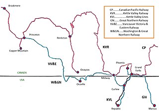
The Vancouver, Victoria and Eastern Railway (VV&E) was a railway line proposed to connect Metro Vancouver with the Kootenays, in Canada. After acquisition by the Great Northern Railway (GN), most of the route was built, but a passenger through service, using the arranged running rights on the tracks of other companies, never transpired.
Chapmans is a locality in the lower Fraser Canyon area of southwestern British Columbia. The place is on the east shore of the Fraser River and north of Alexandra Bridge Park. The locality, on BC Highway 1, is by road about 46 kilometres (29 mi) north of Hope and 64 kilometres (40 mi) south of Lytton.
The Coquihalla railway link, operated by the Kettle Valley Railway (KV), a Canadian Pacific Railway (CP) subsidiary, connected the Coquihalla Summit and Hope in southwestern British Columbia. This standard gauge trackage, which followed the Coquihalla River through the North Cascades, formed the greater part of the KV Coquihalla Subdivision.
Nicola is an unincorporated community in the Nicola region of south central British Columbia. The place is on the north side of the Nicola River at the southwestern end of Nicola Lake. On BC Highway 5A, the locality is by road about 11 kilometres (7 mi) northeast of Merritt, 77 kilometres (48 mi) southeast of Spences Bridge, and 90 kilometres (56 mi) southwest of Kamloops.
The Nicola, Kamloops and Similkameen Coal and Railway Co (NK&S), ultimately a Canadian Pacific Railway (CP) subsidiary, connected Spences Bridge and Nicola in south central British Columbia. This standard gauge trackage, which followed the Nicola River, formed the CP Nicola Subdivision.


