The Sunshine Coast is a geographic subregion of the British Columbia Coast that generally comprises the regional districts of qathet and Sunshine Coast.
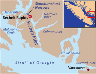
Skookumchuck Narrows is a strait forming the entrance of Sechelt Inlet on British Columbia's Sunshine Coast in Canada. Before broadening into Sechelt Inlet, all of its tidal flow together with that of Salmon Inlet and Narrows Inlet must pass through Sechelt Rapids. At peak flows, standing waves, whitecaps, and whirlpools form at the rapids even in calm weather. The narrows are also the site of Skookumchuck Narrows Provincial Park.
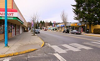
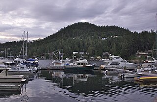
Sechelt is a district municipality located on the lower Sunshine Coast of British Columbia. Approximately 50 km northwest of Vancouver, it is accessible from mainland British Columbia by a 40-minute ferry trip between Horseshoe Bay and Langdale, and a 25-minute drive from Langdale along Highway 101, also known as the Sunshine Coast Highway. The name Sechelt is derived from the she shashishalhem word shíshálh, the name of the First Nations people who first settled the area thousands of years ago.

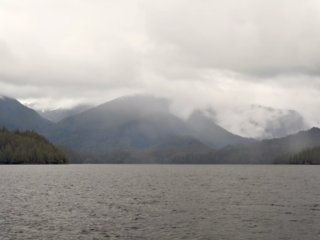
Sechelt Inlet formerly Seechelt Inlet is one of the principal inlets of the British Columbia Coast. The inlet is significant in that it almost makes an island of what is instead the Sechelt Peninsula, whose isthmus is at the town of Sechelt at the head of the inlet. The isthmus is less than 1.2 km (0.75 mi) in length. Sechelt Inlet's mouth is at Jervis Inlet, inland from the Malaspina Strait.

Harmony Islands Marine Provincial Park is a provincial park in British Columbia, Canada, located on the east side of Hotham Sound, which is a side-inlet of the lower reaches of Jervis Inlet, on that inlet's north side roughly opposite the mouth of Sechelt Inlet.

Skookumchuck Narrows Provincial Park is a provincial park in the Sunshine Coast of British Columbia, Canada. It was established on August 25, 1957, to protect the Sechelt Rapids located in the Skookumchuck Narrows between Sechelt Inlet and Jervis Inlet.

Smuggler Cove Marine Provincial Park is a provincial park in British Columbia, Canada located approximately 16 kilometres (9.9 mi) west of Sechelt, a city on the Sunshine Coast.
The Artificial Reef Society of British Columbia (ARSBC) is a registered non-profit society based in Vancouver, British Columbia (BC), and has been a registered tax-deductible charity in Canada since 1992.

HMCS Chaudière was a Restigouche-class destroyer and the second vessel of her class that served in the Royal Canadian Navy and later the Canadian Forces from 1959 to 1974. She was the second Canadian naval unit to bear this name. During the summer of 1974 she along with her sister ship HMCS Columbia served as the base of operations for the Esquimalt Sea Cadet Camp while being docked at the DND jetty in Colwood. This location was across the harbour from the main site of CFB Esquimalt. Following the vessel's decommissioning, the ship was used as a source for spare parts for the other surviving members of her class. In 1991, Chaudière was sold for use as an artificial reef and sunk off the coast of British Columbia.

Salmon Inlet, formerly Salmon Arm, is a fjord branching east from Sechelt Inlet in the British Columbia, Canada. Its companion, Narrows Inlet, another side-inlet of Sechelt Inlet, lies roughly 10 km (6.2 mi) north. Misery and Sechelt Creeks flow freely into the inlet, while the Clowhom River flows in from the artificial Clowhom Lake, formed by a small hydroelectric power development. The fjord is 23 km (14 mi) long; Clowhom Lake, covering a waterfall on the Clowhom River, stretches a further 12 km (7.5 mi) to the western base of Mount Tantalus, which is best known from the direction of Squamish and the Cheakamus Canyon stretch of British Columbia Highway 99. Heavily affected by logging and milling operations, the inlet is split almost into two portions by an alluvial fan spreading from the mouth of Sechelt Creek.
Shark River Reef is an artificial reef located in the Atlantic Ocean, 15.6 miles southeast of Manasquan Inlet, off of the coast of Ocean County, New Jersey. The site contains almost 4 million cubic yards of dredge rock material. Although 96% of the total reef material is rock, the site also contains numerous subway cars.

Nanaimo Harbour, also known as the Port of Nanaimo, is a natural harbour on the east coast of Vancouver Island in the Canadian province of British Columbia. The city of Nanaimo runs along the west side of the harbour. Three islands, Newcastle, Protection, and Gabriola, along with Duke Point, form the eastern edge. The Port of Nanaimo includes the Inner Harbour, Nanaimo River estuary, Departure Bay, the waters on the east side of Newcastle and Protection Islands, and Northumberland Channel. The port is under the management of the Nanaimo Port Authority.
Kumealon Inlet is an inlet on the Coast of British Columbia, Canada. It lies on the eastern side of the north end of Grenville Channel facing Pitt Island.

Port Neville is a bay, port and locality on the north side of Johnstone Strait, south of Call Inlet, in the Central Coast region of British Columbia, Canada.

Recreational dive sites are specific places that recreational scuba divers go to enjoy the underwater environment or for training purposes. They include technical diving sites beyond the range generally accepted for recreational diving. In this context all diving done for recreational purposes is included. Professional diving tends to be done where the job is, and with the exception of diver training and leading groups of recreational divers, does not generally occur at specific sites chosen for their easy access, pleasant conditions or interesting features.
Narrows Inlet formerly Narrows Arm is a fjord branching east from Sechelt Inlet in British Columbia, Canada. Its companion, Salmon Inlet, another side-inlet of Sechelt Inlet, lies roughly 10 km (6.2 mi) south.


