
Big Thunder Mountain Railroad is a mine train roller coaster located at Disneyland, Magic Kingdom, Tokyo Disneyland and Disneyland Park (Paris). In Tokyo and Paris, the attraction is named Big Thunder Mountain. Big Thunder Mountain Railroad is also the name of the fictional rail line the roller coaster depicts.

Unorganized Thunder Bay District is an unorganized area in northwestern Ontario, Canada in Thunder Bay District. It comprises all parts of the district that are not part of an incorporated municipality or a First Nations reserve.

Sleeping Giant Provincial Park, established in 1944 as Sibley Provincial Park and renamed in 1988, is a 244-square-kilometre (94 sq mi) park located on the Sibley Peninsula in Northwestern Ontario, east of Thunder Bay. The nearest communities are Pass Lake, in the township of Sibley, located at the northern entrance to the park, and Dorion, located 35 kilometres (22 mi) northwest, in the township of Shuniah. The seasonal community of Silver Islet is located on the southern tip of the peninsula. The primary feature of the park is the Sleeping Giant, which is most visible from the city of Thunder Bay.

Highway 18 is a 161-kilometre (100 mi) highway in Alberta, Canada. It stretches from Highway 43 at the hamlet of Green Court, through the towns of Barrhead and Westlock, to Highway 63 east of the hamlet of Thorhild.

The Heritage Junior Hockey League (HJHL), formally the Heritage Junior B Hockey League, is a Junior B ice hockey league in Alberta, Canada, sanctioned by Hockey Canada. The HJHL was founded in 1987 and is made up of teams from southern and central Alberta. The HJHL is the largest Junior B league in the province, with 13 teams. The top two teams qualify for the Alberta Provincial Junior B Hockey Championship, whose winner had an option to compete in the Keystone Cup.
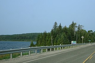
White Lake Provincial Park is a park in the Thunder Bay District of Northern Ontario, Canada, along Highway 17, north of Lake Superior.

Thunder Lake Provincial Park is a provincial park located in Alberta, Canada, and is located 140 kilometres (87 mi) west of Edmonton, on the shore of the park features setting for boating, water-skiing, swimming, running, fishing and camping. Thunder lake is approximately 21 kilometres (13 mi) West of the nearest town, Barrhead.

Secondary Highway 599, commonly referred to as Highway 599, is a provincially maintained secondary highway in the Canadian province of Ontario. The 291.0 km (180.8 mi) route connects Highway 17 near Ignace with the remote northern community of Pickle Lake; its terminus at Pickle Lake marks the northernmost point on the provincial highway system. Highway 599 was first assigned in 1956 between Savant Lake and Pickle Lake, although it did not connect with the rest of the provincial highway system at the time. Construction to link it with Highway 17 in Ignace took place between 1958 and 1966. The northern end of Highway 599 is one of two possible starting points for a road to the Ring of Fire mineral deposits, the other being Highway 584 in Nakina.
Highway 123 is a provincial highway in the Canadian province of Saskatchewan. It runs from Highway 55, 600 metres (2,000 ft) east of its intersection with Highway 23, to Cumberland House on Cumberland Island. It is about 137 kilometres (85 mi) long.
King's Highway 102, commonly referred to as Highway 102, formerly as Highway 11A and Highway 17A and historically as the Dawson Road, is a provincially maintained highway in the Canadian province of Ontario, serving as a northern bypass to the city of Thunder Bay for all vehicle traffic. Both the western and eastern termini of Highway 102 are with the concurrency of Highway 11 and Highway 17; in the rural community of Sistonens Corners to the west and in Thunder Bay to the east. The majority of Highway 102 is surrounded by thick forests and swamps. However, owing to its historic nature, it is lined with residences outside of urban Thunder Bay.

The Boreal Plains Ecozone, as defined by the Commission for Environmental Cooperation (CEC), is a terrestrial ecozone in the western Canadian provinces of Manitoba, Saskatchewan and Alberta. It also has minor extensions into northeastern British Columbia and south-central Northwest Territories. The region extends over 779,471 km2, of which 58,981 km2 is conserved.

Urban parks in Canada are areas that offer recreation and green spaces to residents of a municipality. An urban park is often owned or maintained by a municipal government. However, several parks and green spaces may also be maintained or owned by a conservation authority, regional government, provincial government, or the federal government. Canada's national parks system, managed by Parks Canada, includes one urban park, although the agency has plans to create additional national urban parks.
Montreal Lake is a lake in the north-central part of Canadian province of Saskatchewan. It is the source of the Montreal River and is located between Highways 2 and 969. Prince Albert National Park is to the west and Clarence-Steepbank Lakes Provincial Park is to the east. Communities on the lake include Montreal Lake, Timber Bay, and Molanosa.
Thunder Lake is a hamlet in central Alberta within the County of Barrhead No. 11. It is located on the eastern shore of Thunder Lake, just south of Thunder Lake Provincial Park, and is about 5 kilometres (3.1 mi) west of Highway 18 and approximately 21 kilometres (13 mi) west of Barrhead.

The Rural Municipality of Moose Range No. 486 is a rural municipality (RM) in the Canadian province of Saskatchewan within Census Division No. 14 and SARM Division No. 4.

Big Thunder Ski Jumping Centre was a twin ski jumping hill located in Thunder Bay in Northwestern Ontario, Canada. It constitutes part of Big Thunder National Training Centre. The first hills were built by Knute and Thor Hansen and opened in 1963. They were originally known as Lille Norway Ski Area, then Mt. Norway Ski Area, and Sundance Northwest Resort before taking the current name. The large and normal hills were built in 1974 and the venue was taken over by the provincial government in 1985. The hills hosted 29 FIS Ski Jumping World Cup and 50 Canadian Ski Jumping Championships tournaments between 1975 and 1995, climaxing with the FIS Nordic World Ski Championships 1995. Funding was then cut and the venue has since been closed and unmaintained.
Gravel River Provincial Park is a nature reserve in the Thunder Bay District of Ontario, Canada. It protects an unusual birds-foot delta at the mouth of the Gravel River.
Waskesiu Upland is a hilly plateau in the central region of the Canadian province of Saskatchewan. Waskesiu means red deer or elk in the Cree language. The plateau is just south-west of the geographical centre of the province and consists of two main ranges — the Waskesiu Hills to the south and the Thunder Hills to the north. The Thunder Hills cover an area of about 225,000 acres. Several notable rivers begin from the upland with ones headed south flowing into the North Saskatchewan River and ones headed north flowing into the Churchill River. Much of the plateau is carpeted in boreal forests and most of the Waskesiu Hills range is within Prince Albert National Park. Besides the national park, there are several provincial recreation sites in and around the upland. The northern part of the upland is part of the Northern Saskatchewan Administration District and is sparsely populated.

