
Lasqueti Island is an island off the east coast of Vancouver Island in the Strait of Georgia, qathet Regional District, British Columbia, Canada and has a population of 498. A passenger-only ferry connects the island to the community of French Creek, near Parksville. The ferry makes two to three runs per day, six days per week, weather permitting. The ferry service is run by Western Pacific Marine for BC Ferries.
Anderson Bay Provincial Park is a provincial park in British Columbia, Canada, located on the southeast end of Texada Island near the community of Gillies Bay. Created in 2000, it is approximately 35 hectares in area.
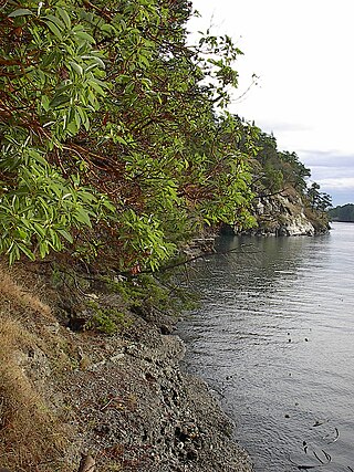
Collinson Point Provincial Park is a provincial park on Galiano Island, British Columbia, Canada. It is located between Mount Galiano and the western approaches to Active Pass. The area is 23.68 hectares, with approximately 500 metres of waterfront.

Englishman River Falls Provincial Park is a provincial park in British Columbia, Canada. It is located west of Parksville and borders the small community of Errington on Vancouver Island.

Goldstream Provincial Park is a provincial park in British Columbia, Canada. It is known for the annual fall salmon runs in the Goldstream River, and the large numbers of bald eagles that congregate to feed at that time. The total size of the park is 3.79 km2. It is located in the city of Langford. Recreational fishing is only accessible to indigenous cultures, and not local non-indigenous residents.

Gowlland Tod Provincial Park is a provincial park in British Columbia, Canada. The park protects 1,219 hectares of mixed forest of Douglas-fir, Arbutus, western redcedar, western hemlock, shore pine, grand fir, red alder, and Garry oak within the District Municipality of Highlands and the Juan de Fuca Electoral Area. Rocky outcroppings support Manzanita, Scotch broom, and Oregon grape. The peaks of the Gowlland Range, from which the park derives its name, loom over 400 m (1,300 ft) above Saanich Inlet, providing vistas of The Malahat to the west. Farther north, the park curves around inland, bounded to the north by the municipality of Central Saanich. The park also encompasses the rural community of Willis Point. There are 25 km (16 mi) of maintained trails within the park, accessible in the south from roads leading to the park from Highlands, as well as from trails alongside Tod Inlet and McKenzie Bight to the north. Trails connect to Mount Work Regional Park and Lone Tree Hill Regional Park.
Height of the Rockies Provincial Park is a provincial park in the Canadian Rockies of south eastern British Columbia, Canada. It is located west of the Continental Divide, adjacent to Elk Lakes Provincial Park.

Hesquiat Peninsula Provincial Park is a provincial park at the western extremity of the Clayoquot Sound region of the West Coast of Vancouver Island, British Columbia, Canada. The park was established by order-in-council on July 12, 1995 as part of the Clayoquot Land-Use Decision.

Juan de Fuca Provincial Park is a provincial park located on the west coast of Vancouver Island in British Columbia, Canada. The park was established on April 4, 1996 by combining three former parks — China Beach, Loss Creek, and Botanical Beach — into one provincial park. It is the location of the majority of the Juan de Fuca Marine Trail, which is a southern compliment to the West Coast Trail within Pacific Rim National Park Reserve.
ȽÁU,WELṈEW̱/John Dean Provincial Park, formerly John Dean Provincial Park, is a small, densely vegetated provincial park on the Saanich Peninsula of southern Vancouver Island, British Columbia, Canada. The park is located on and around ȽÁU,WELṈEW̱, a small mountain in the traditional territory of Wsanec First Nations, itself situated 20 km north of Victoria, the provincial capital city.

Little Qualicum Falls Provincial Park is a provincial park in British Columbia, Canada, on central Vancouver Island, that encompasses the entire southern shore of Cameron Lake. The Island Rail Corridor line to Port Alberni passes through the park.

MacMillan Provincial Park is a 301-hectare (740-acre) provincial park in British Columbia, Canada. Located 25 km (16 mi) west of Qualicum Beach and 16 km (9.9 mi) east of Port Alberni, the park straddles Highway 4 and the Island Rail Corridor in central Vancouver Island. It is nestled on the western shore of Cameron Lake, and protects the delta of the Cameron River. The park is home to a famous, 157-hectare (390-acre) stand of ancient Douglas fir, known as Cathedral Grove, which draws visitors from all over the world. The park provides the only highway-accessible protected old-growth Douglas-fir forest in British Columbia. In 2007 Cathedral Grove made the short list on CBC's competition Seven Wonders of Canada.

Maquinna Marine Provincial Park and Protected Area is a provincial park in British Columbia, Canada, located northwest of Tofino in the Clayoquot Sound region of the West Coast of Vancouver Island, protecting Ramsay Hot Springs, which is the name-source of the cove, settlement and former post office of Hot Springs Cove.

Rathtrevor Beach Provincial Park is a provincial park in Parksville, British Columbia, Canada. Located at the east end of the town, the 347-hectare park features a two-kilometre long stretch of sandy beach, a stand of old-growth Douglas fir trees and 250 vehicle-accessible and 25 walk-in camping spaces. Popular year-round, the park is easily accessible from Highway 19. The sandy beach is the main attraction. At low tide, it stretches nearly a kilometre out into the Strait of Georgia.
Sydney Inlet Provincial Park is a provincial park in the Clayoquot Sound region of the west coast of Vancouver Island, British Columbia, Canada, located north of the settlement of Hot Springs Cove and northwest of the resort town of Tofino. Sydney Inlet was the name of the post office in the area from its creation in 1947 to 1948, when it was renamed Hot Springs Cove, though that post office was subsequently closed in 1974.

Spider Lake Provincial Park is a provincial park located on Vancouver Island in British Columbia, Canada. It was established on June 18, 1981, to protect the ecological integrity of the lake and to provide day use visitors with recreational facilities.
Sulphur Passage Provincial Park is a provincial park in British Columbia, Canada, located in the central part of the Clayoquot Sound region of the West Coast of Vancouver Island, British Columbia, Canada. It is located around Obstruction Island to the northeast of Flores Island. The eponymous Sulphur Passage is located on the east side Obstruction Island.
Tranquil Creek Provincial Park is a provincial park in British Columbia, Canada, located at the head of the Kennedy River, east of the head of Bedwell Sound on Vancouver Island.
Clayoquot Sound Biosphere Reserve is a UNESCO Biosphere Reserve situated in Clayoquot Sound on the west coast of Vancouver Island in British Columbia, Canada. A diverse range of ecosystems exist within the biosphere reserve boundaries, including temperate coastal rainforest, ocean and rocky coastal shores.

Mount Arrowsmith Biosphere Region (MABR) is a UNESCO Biosphere Reserve located on the east coast of Vancouver Island in British Columbia, Canada. It was designated in 2000 by UNESCO to protect a large second-growth coast Douglas fir ecosystem in the watersheds of the Little Qualicum and Englishman Rivers from being developed.


