Lytton is a village of about 250 residents in southern British Columbia, Canada, on the east side of the Fraser River and primarily the south side of the Thompson River, where it flows southwesterly into the Fraser. The community includes the Village of Lytton and the surrounding community of the Lytton First Nation, whose name for the place is Camchin, also spelled Kumsheen.

The Stein Valley Nlaka’pamux Heritage Park is located near Lytton, British Columbia. The park was established in 1995. The park is co-managed, operated, and planned through a partnership between the Lytton First Nation and the government of British Columbia. The park provides recreational opportunities and cultural heritage activities, and features a number of pictographs.

Bridal Veil Falls Provincial Park is a BC Park situated on the Trans-Canada Highway just east of Rosedale, British Columbia, Canada, within of the City of Chilliwack. The community of Bridal Falls is located adjacent to the falls and park, as well as the interchange between the Trans-Canada and BC Highway 9, offering a variety of highway-based tourism services. Access to the falls requires a short hike from the parking lot and well-groomed trails, taking most groups 15-25 minutes.

The Fraser Canyon is a major landform of the Fraser River where it descends rapidly through narrow rock gorges in the Coast Mountains en route from the Interior Plateau of British Columbia to the Fraser Valley. Colloquially, the term "Fraser Canyon" is often used to include the Thompson Canyon from Lytton to Ashcroft, since they form the same highway route which most people are familiar with, although it is actually reckoned to begin above Williams Lake at Soda Creek Canyon near the town of the same name.

The Lillooet Ranges are the southeasternmost subdivision of the Pacific Ranges of the Coast Mountains of British Columbia. They are located between the drainage of the Lillooet River and Harrison Lake on the west and the canyon of the Fraser River on the east, and by the lowland coastal valley of that river on the south.

The Cantilever Range is a mountain range in southwestern British Columbia, Canada, a subrange of the Lillooet Ranges, which is itself a subgrouping of the Pacific Ranges of the Coast Mountains. About 1100 km2 in area and about 50 km east to west and 35 km north to south, the Cantilever Range is located southwest of Lytton between the valleys of the Stein River (N) and Kwoiek Creek (S).

Alexandra Bridge Park lies within the lower Fraser Canyon of British Columbia, Canada. This provincial park is adjacent to the historic suspension bridge from 1926, which spans the Fraser River and was built using the eastern abutment of the bridge from 1863. The locality, on BC Highway 1, is by road about 44 kilometres (27 mi) north of Hope and 65 kilometres (40 mi) south of Lytton.
Liard River Hot Springs Provincial Park is a provincial park in British Columbia, Canada. It is home to the second largest natural hot springs in Canada, after Deer River Hot Springs 15 km to the north east. It is a natural river of hot water rather than a spring fed man made pool. The park is part of the larger Muskwa-Kechika Management Area. The community of Liard River, British Columbia is located nearby.

Brandywine Falls Provincial Park is a provincial park in British Columbia, Canada, located adjacent to BC Highway 99 between Garibaldi and Whistler, British Columbia. It is managed by Sea to Sky Parks for BC Parks.

Golden Ears Provincial Park is a 555.9 square kilometres (214.6 sq mi) provincial park in British Columbia, Canada. It is named after the prominent twin peaks, which are commonly referred to as Golden Ears. The park was originally part of Garibaldi Provincial Park but was split off as a separate park in 1967. The area was logged extensively in the 1920s by the Lougheed and Abernathy Logging Company. Many recreational attractions are found within the park. Golden Ears Provincial Park is a protected area that contains many endangered species of flora and fauna.
Coquihalla River Provincial Park is a provincial park in British Columbia, Canada, located 25 km (16 mi) north of the town of Hope on BC Highway 5 adjacent to the Coquihalla River.

E.C. Manning Provincial Park is a provincial park in British Columbia, Canada. It is usually referred to as Manning Park, although that nomenclature is also used to refer to the resort and ski area at the park's core. The park covers 83,671 hectares (323 mi2) and was the second most visited provincial park in 2017-18 after Cypress Provincial Park. The park lies along British Columbia Highway 3, and occupies a large amount of land between Hope and Princeton along the Canada-United States border.
Goldpan Provincial Park is a provincial park in British Columbia, Canada, on the Trans-Canada Highway between Lytton and Spences Bridge, on the Thompson River. The park has camping above the highway and a picnic area and riverfront below.

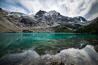
Joffre Lakes Provincial Park is a class A provincial park located 35 kilometres (22 mi) east of Pemberton in British Columbia, Canada. It was established in 1996, when Joffre Lakes Recreation Area was upgraded to park status.

MacMillan Provincial Park is a 301-hectare (740-acre) provincial park in British Columbia, Canada. Located 25 km (16 mi) west of Qualicum Beach and 16 km (9.9 mi) east of Port Alberni, the park straddles Highway 4 and the Island Rail Corridor in central Vancouver Island. It is nestled on the western shore of Cameron Lake, and protects the delta of the Cameron River. The park is home to a famous, 157-hectare (390-acre) stand of ancient Douglas fir, known as Cathedral Grove, which draws visitors from all over the world. The park provides the only highway-accessible protected old-growth Douglas-fir forest in British Columbia. In 2007 Cathedral Grove made the short list on CBC's competition Seven Wonders of Canada.

Nancy Greene Provincial Park is a provincial park in British Columbia, Canada, located approximately 27 km (17 mi) northwest of the city of Rossland and 31 km (19 mi) west of the city of Castlegar in that province's West Kootenay region, at the junction of Highway 3 and Highway 3B. It is named for Nancy Greene, Canadian Olympic medallist in downhill skiing, who is a native of Rossland.
Nicolum River Provincial Park, formerly Nicolum Provincial Park, is a provincial park in British Columbia, Canada, located at the confluence of the Nicolum and Coquihalla Rivers near the town of Hope. The park is a Class A, category 6 Provincial Park.

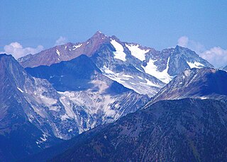
Skihist Mountain, also sometimes referred to as Skihist Peak, is the highest mountain in the Cantilever Range and in southwestern British Columbia, Canada. It is located on the southern boundary of Stein Valley Nlaka'pamux Heritage Park, about 20 km (12 mi) west of Lytton. It is the highest summit in the Lillooet Ranges, which lie between the Lillooet and Fraser Rivers, south of the Gates Valley and Seton and Anderson Lakes.
Mount Brew is a mountain located 12 km (7 mi) south of Lillooet and 44 km (27 mi) north of Skihist Mountain in south-central British Columbia, Canada. It lies on the western side of the Fraser River and is the third-highest mountain of the Lillooet Ranges, after Skihist Mountain and Petlushkwohap Mountain in the Cantilever Range to the west of Lytton.

A wildfire began on June 30, 2021 just south of the village of Lytton in the interior of British Columbia, Canada. The fire destroyed much of Lytton and caused two civilian fatalities, announced July 3. Several missing residents, still unaccounted for at that time, were later located. The fire, one of the 2021 British Columbia wildfires throughout the province, was facilitated by the 2021 Western North America heat wave.


