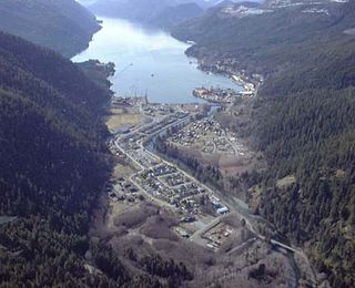
Tahsis is a village municipality on the west coast of Vancouver Island, British Columbia, Canada, about 300 km (186 mi) northwest of the provincial capital Victoria at 49°55′33″N126°37′16″W. As of 2011, the Canadian census listed 316 residents, a decline from the 2006 Census count of 366 residents. The Village of Tahsis economy used to be dependent on forestry, but after the closure of the local sawmill in 2001, the economy became heavily dependent on sport fishing for salmon and halibut, outdoor recreation and tourism.
The Stave River is a tributary of the Fraser, joining it at the boundary between the municipalities of Maple Ridge and Mission, about 35 kilometres (22 mi) east of Vancouver, British Columbia, Canada, in the Central Fraser Valley region.

Bligh Island Marine Provincial Park is a provincial park in British Columbia, Canada.
Conkle Lake Provincial Park is a provincial park in British Columbia, Canada, west of the confluence of the Kettle and West Kettle Rivers. The park size is 587 hectares. Bird species that live in the area are the common loon, merganser, ruffed grouse, pileated woodpecker, black-capped chickadee, and ruby-crowned kinglet. Mammals that live in the area are bears, squirrels, raccoons, rodents, beavers, deer, rabbits, foxes, and moose.
Eskers Provincial Park is a provincial park in British Columbia, Canada. The park comprises roughly 4,044 hectares and was created in 1987. Located west of Nukko Lake, which lies northwest of the city of Prince George, it protects an area of the 40-kilometre (25 mi) Stuart River Eskers Complex. Eskers are winding ridges of gravel formed by the glaciers which once covered the British Columbia Interior.

Monck Provincial Park is a provincial park in British Columbia, Canada, located at Nicola Lake near the town of Merritt. The park's campground is one of those which accepts reservations. Activities including fishing, camping and hiking. Natural features other than Nicola Lake include lava beds associated with the Chilcotin Group.

Nuchatlitz Provincial Park is a provincial park in British Columbia, Canada, located on the northwest side of Nootka Island, facing Nuchatlitz Inlet, on the west coast of Vancouver Island. Established in 1996, the park contains approximately 2105 ha.
Pyramid Creek Falls Provincial Park is a provincial park in British Columbia, Canada, located on the east side of the North Thompson River between the towns of Blue River (S) and Valemount (N).
Shuswap Lake Marine Provincial Park is a provincial park in British Columbia, Canada, comprising 894 ha. The Park has a variety of amenities including boat launch ramps, picnic areas, and 27 campsites around the perimeter of Shuswap Lake. The lake's name and that of the surrounding Shuswap Country is from the Shuswap people (Secwepemc), the most northern of the Salishan speaking people.

South Texada Island Provincial Park is a provincial park in British Columbia, Canada. It is located on the SouthWest side of Texada Island. Created in 1997, the park is approximately 900 hectares in area.

Sugarbowl-Grizzly Den Provincial Park and Protected Area is a provincial park in British Columbia, Canada.
Todagin South Slope Provincial Park is a provincial park in British Columbia, Canada, located on the west side of Todagin Creek to the east of Kinaskan Lake in the Stikine Country, to the south of the community of Dease Lake. Created in 2001, it contains c. 3557 ha.
There are several lakes named Mud Lake within the Canadian province of Saskatchewan.

The Gwa'sala-Nakwaxda'xw Nations are an amalgamation of two Kwakwaka'wakw peoples in a band government based on northern Vancouver Island in British Columbia, whose main reserve community is near the town of Port Hardy in the Queen Charlotte Strait region of the Central Coast region of British Columbia, Canada. In the 1960s the Gwa'sala (Gwaʼsa̱la), the 'Nakwaxda'xw (ʼNakʼwaxdaʼx̱w) and the Kwakiutl peoples were amalgamated. Later the Gwa'sala-'Nakwaxda'xw Nations and the Kwakiutl First Nation separated into the two groups that are recognized by the federal government. Gwa'sala-'Nakwaxda'xw Nations were forcibly relocated from their homelands to a location near Port Hardy.

Doumbala is a department or commune of Kossi Province in western Burkina Faso. Its capital lies at the town of Doumbala. According to the 2019 census the department has a total population of 33,326.
The Lac des Îles igneous complex of northwestern Ontario, Canada is a layered gabbroic intrusion which is the host for the largest palladium orebody in Canada. The orebody is currently being mined as a combined open pit and underground operation by North American Palladium.
The Gataga River is a river in the Northern Rockies of British Columbia, Canada. It is a tributary of the Kechika River, which is a tributary of the Liard.
The Firesteel River is the uppermost left tributary of the Finlay River in the Northern Interior of British Columbia, Canada. The river originates at Tatlatui Lake, while the Finlay originates at the outlet of Thutade Lake, to the southeast, which is considered the ultimate source of the Mackenzie River.
The Douglas First Nation, aka the Douglas Indian Band, Douglas Band, or Xa'xtsa First Nation, are a band government of the In-SHUCK-ch Nation, a subgroup of the larger St'at'imc people, also referred to as Lower Stl'atl'imx. The Douglas, Skatin and Samahquam communities are related through familial ties as well as culturally and linguistically. The In-SHUCK-ch are the southernmost of the four divisions making up the Lillooet ethnographic group. The Douglas First Nation's main community is at Xa'xtsa, a village on their main reserve at the head of Harrison Lake, near the former gold rush port-town of Port Douglas.
Gbi & Doru District is one of 17 districts of Nimba County, Liberia. As of 2008, the population was 8,131.


