
Wardner is a city in Shoshone County, Idaho, United States. Located in the Silver Valley mining region, the population was 188 at the 2010 census, down from 215 in 2000.

Brighton is a town in Franklin County, New York, United States. The population was 1,435 at the 2010 census. It was named after Brighton, England, by early surveyors in the region.

Mount Robson Provincial Park is a provincial park in the Canadian Rockies with an area of 2,249 km2. The park is located entirely within British Columbia, bordering Jasper National Park in Alberta. The B.C. legislature created the park in 1913, the same year as the first ascent of Mount Robson by a party led by Conrad Kain. It is the second oldest park in the provincial system. The park is named for Mount Robson, which has the highest point in the Canadian Rockies and is located entirely within the park.
A provincial park is a park administered by one of the provinces of a country, as opposed to a national park. They are similar to state parks in other countries. They are typically open to the public for recreation. Their environment may be more or less strictly protected.

Porteau Cove Provincial Park is a provincial park located along the eastern shore of Howe Sound in British Columbia, Canada.

Bragg Creek Provincial Park is a Canadian provincial park in Alberta's Rocky Mountains at the eastern edge of Kananaskis Country. This park is located near the Elbow River and includes facilities for picnicking, hiking, and fishing.

Pinecone Burke Provincial Park is a provincial park in British Columbia, Canada. It extends from the southwest corner of Garibaldi Provincial Park, west of Pitt Lake and Pitt River to include Burke Mountain in the City of Coquitlam. Most of the park is unserviced wilderness with very rough trails such as the Fools Gold Trail in the Boise Valley. There is canoe access to Widgeon Slough and from there hiking trails that lead to Widgeon Lake, and a network of old logging roads, hiking and mountain biking trails on Burke Mountain. Visitors can also use the park for camping, backcountry skiing, and snowshoeing.

Shannon Falls Provincial Park is a provincial park in British Columbia, Canada. It is located 58 kilometers (36 mi) from Vancouver and 2 kilometers (1.2 mi) south of Squamish along the Sea to Sky Highway.
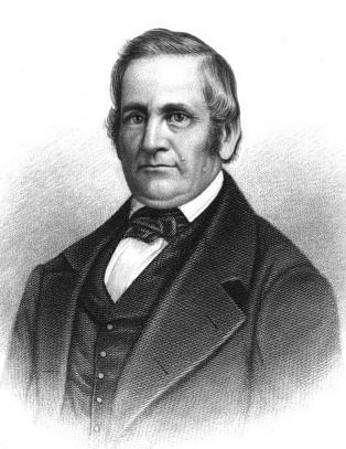
Silas Hemenway Jennison was an American Anti-Masonic and Whig politician who served as Vermont's 11th lieutenant governor and 14th governor of Vermont – the first born in the state.

Spray Valley Provincial Park is a provincial park located east of the Rocky Mountains, along the Spray River in western Alberta, Canada.
Silver Mountain Resort is a ski resort in the northwest United States, located in the Silver Valley region of northern Idaho, just south of Kellogg and Interstate 90 in Shoshone County. Originally opened as "Jackass Ski Bowl" in January 1968 on Wardner Peak, it was renamed "Silverhorn" in 1973 following an ownership change. With planned improvements, most notably the gondola from the city of Kellogg and expansion on Kellogg Peak, the name was changed to "Silver Mountain" in the summer of 1989.

Wardner is a side-scrolling platform game developed by Toaplan and published in arcades worldwide by Taito in 1987.

The Coeur d'Alene, Idaho, labor riot of 1899 was the second of two major labor-management confrontations in the Coeur d'Alene mining district of northern Idaho in the 1890s. Like the first incident seven years earlier, the 1899 confrontation was an attempt by union miners, led by the Western Federation of Miners to unionize non-union mines, and have them pay the higher union wage scale. As with the 1892 strike, the 1899 incident culminated in a dynamite attack that destroyed a non-union mining facility, the burning of multiple homes and outbuildings and two murders, followed by military occupation of the district.
The Muskwa-Kechika Management Area is a provincially-run tract of land in the far north of British Columbia. It has an advisory board that counsels the government on land-use decisions. Established by provincial government legislation in 1998, the area is meant to be preserved as a wild area, but development is not outright forbidden; the land is divided into different zones, with varying levels of protection, although the whole area is to be used according to an overall plan. The original concept called for 25% of the land to be turned into provincial parks, 60% to become "special management zones", and 15% to become "special wild land zones", where logging would be prohibited. The original size of the M-KMA was 4,450,000 hectares. However, in 2000, with the approval of the Mackenzie Land and Resource Management Plan (LRMP), over 1,900,000 hectares were added to the M-KMA for a total area of 6,400,000 hectares —an area slightly smaller than the US state of Maine, or the entire island of Ireland, or seven times the size of Yellowstone National Park, in Wyoming.

George Albert Clough was an architect working in Boston in the late 19th-century. He designed the Suffolk County Courthouse in Pemberton Square, and numerous other buildings in the city and around New England. Clough served as the first City Architect of Boston from 1876 to 1883.

Rich Wardner is a former Republican member of the North Dakota Senate for the 37th district.
Wardner, British Columbia is a small town located 27 km east of Cranbrook and 25.7 km west of Fernie. The unincorporated settlement runs parallel to the Kootenay River beside Highway 3/93.
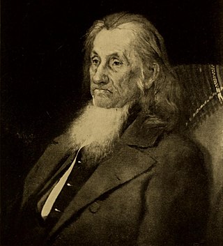
Allen Wardner was a Vermont banker, businessman and politician who served as State Treasurer. He was also the father-in-law of Attorney General, Secretary of State and United States Senator William M. Evarts.
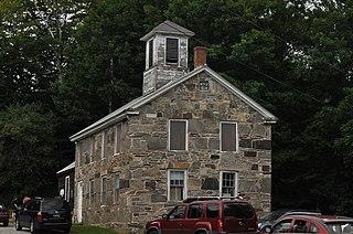
The South Reading Schoolhouse is a historic school building at Tyson and Bartley Roads in Reading, Vermont. Built in 1834, it is a distinctive example of the regional "snecked masonry" style, and the oldest known structure of the style to survive. It was used as a school until 1970, and was listed on the National Register of Historic Places in 1983.
Laura Chenoweth Butz was an American educator. After moving from the Midwest to Shoshone County, Idaho in 1899, she became involved in local schools in a region dominated by silver mining. She served as the Superintendent of Wardner-Kellogg City Schools in Idaho for eight years, 1915-1923. She also served as assistant to the Idaho State Superintendent Research Secretary in the Department of Education in Boise, Idaho.

