
Brighton is a town in Franklin County, New York, United States. The population was 1,435 at the 2010 census. It was named after Brighton, England, by early surveyors in the region.

Kootenay National Park is a national park located in southeastern British Columbia, and is one component of the Canadian Rocky Mountain Parks World Heritage Site. The park consists of 1,406 km2 (543 sq mi) of the Canadian Rockies, including parts of the Kootenay and Park mountain ranges, the Kootenay River and the entirety of the Vermilion River. While the Vermilion River is completely contained within the park, the Kootenay River has its headwaters just outside the park boundary, flowing through the park into the Rocky Mountain Trench, eventually joining the Columbia River. It ranges in elevation from 918 m (3,012 ft) at the southwestern park entrance, to 3,424 m (11,234 ft) at Deltaform Mountain. Initially called "Kootenay Dominion Park", the park was created in 1920 as part of an agreement between the province of British Columbia and the Canadian federal government to build a highway in exchange for title to a strip of land, approximately 8 km (5.0 mi) on either side of the 94 km route, the Banff–Windermere Highway, to be used solely for park purposes. While the park is open all year, the major tourist season lasts from June to September. Most campgrounds are open from early May to late September, while limited winter camping is available only at the Dolly Varden campground.

The Kootenay is a major river in the Northwest Plateau, within the borders of southeastern British Columbia, Canada, and northern Montana and Idaho in the United States. It is one of the uppermost major tributaries of the Columbia River, the largest North American river that empties into the Pacific Ocean. The Kootenay River runs 781 kilometres (485 mi) from its headwaters in the Kootenay Ranges of the Canadian Rockies, flowing from British Columbia's East Kootenay region into northwestern Montana, then west into the northernmost Idaho Panhandle and returning to British Columbia in the West Kootenay region, where it joins the Columbia at Castlegar.

Castlegar is the second largest community in the West Kootenay region of British Columbia, Canada.

Creston is a town of 5,351 people in the Kootenay region of southeastern British Columbia, Canada on the unceded ancestral territory of the Kutenai First Nation. Creston is roughly equidistant between Cranbrook and Castlegar along the Crowsnest Highway. The town is located approximately 10 km (6 mi) north of the United States border at Porthill, Idaho, with many businesses in Creston accepting American currency and businesses in Porthill accepting Canadian currency and selling gasoline in litres. Creston is one of the few towns in British Columbia that does not observe daylight saving time, remaining on Mountain Standard Time year round.

Salmo is in the West Kootenay region of southeastern British Columbia. The village municipality is mostly on the north side of Erie Creek at the confluence with the Salmo River. The place lies largely east of the junction of BC Highway 3, and BC Highway 6.

Fort Steele is a heritage town in the East Kootenay region of British Columbia, Canada. It is located north of the Crowsnest Highway along Highways 93 and 95, 16 kilometres (9.9 mi) northeast of Cranbrook.

The Dewdney Trail is a 720 km (450 mi) trail in British Columbia, Canada that served as a major thoroughfare in mid-19th century British Columbia. The trail was a critical factor in the development and strengthening of the newly established British Colony of British Columbia, tying together mining camps and small towns that were springing up along the route during the gold rush era prior to the colony's joining Canadian Confederation in 1871. The route's importance and urgency was prompted because many new gold finds were occurring at locations near the US border that were much more easily accessed from Washington Territory than via any practicable route from the barely settled parts of the Lower Mainland and Cariboo. Today, approximately 80 percent of the former trail has been incorporated into the Crowsnest Highway.

Ainsworth Hot Springs, previously named Ainsworth, is a historic village on Kootenay Lake in British Columbia, Canada and has a population of 20. Founded on May 31, 1883, it is the oldest surviving community on Kootenay Lake. Ainsworth Hot Springs is located on Highway 31, 11 miles (18 km) north of Balfour and 12 miles (19 km) south of Kaslo, British Columbia. Today, Ainsworth Hot Springs and the Cody Caves are a popular destination for tourists and spelunkers.

Moyie is an unincorporated community in the East Kootenay region of British Columbia, Canada. It is located on Highway 3, 19 miles (30 km) south of Cranbrook on the eastern shore of Moyie Lake.
British Columbia Highway 3, officially named the Crowsnest Highway, is an 841-kilometre (523 mi) highway that traverses southern British Columbia, Canada. It runs from the Trans-Canada Highway (Highway 1) at Hope to Crowsnest Pass at the Alberta border and forms the western portion of the interprovincial Crowsnest Highway that runs from Hope to Medicine Hat, Alberta. The highway is considered a Core Route of the National Highway System.

Elko is located at the junction of Highway 93 and the Crowsnest Highway, to the north of the Roosville Canada–United States border crossing. A small sawmill town, Elko is situated near the southern end of the Rocky Mountain Trench at the edge of a plateau at the base of the Canadian Rockies, in the East Kootenay region of southeastern British Columbia.

Minto was a sternwheel steamboat that ran on the Arrow Lakes in British Columbia from 1898 to 1954. In those years of service, Minto had steamed over 3.2 million kilometers serving the small communities on Arrow Lakes. Minto and her sister Moyie were the last sternwheelers to run in regularly scheduled passenger service in the Pacific Northwest. The "Minto" class of sailing dinghies is named after this vessel.

Lytton was a sternwheel steamboat that ran on the Arrow Lakes and the Columbia River in southeastern British Columbia and northeastern Washington from 1890 to 1904.

Columbia was a sternwheel steamboat that ran on the Arrow Lakes in British Columbia from 1891 to 1894. Columbia should be distinguished from the many other vessels with the same or similar names, including in particular the propeller-driven steamboat Columbia that ran on the Arrow Lakes for many years.
Raspberry is an unincorporated community in the West Kootenay region of southeastern British Columbia. On the northeast side of the Columbia River adjacent to the mouth of Norns Creek, the residential area is part of Greater Castlegar.
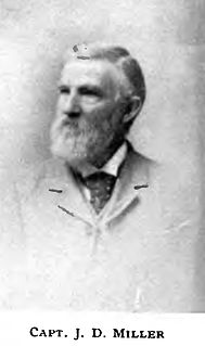
James D. Miller was a steamboat captain in the Pacific Northwest from 1851 to 1903. He became well known for his long length of service, the large number of vessels he commanded, and the many different geographical areas in which he served.
Francis Patrick Armstrong was a steamboat captain in the East Kootenay region of British Columbia. He also operated steamboats on the Kootenay River in Montana and on the Stikine River in western British Columbia. Steam navigation in the Rocky Mountain Trench which runs through the East Kootenay region was closely linked to Armstrong's personality and career. In addition to being a steamboat captain, Armstrong was also a prospector, white-water boat pilot and guide in the Big Bend country of the Columbia River.

From 1886 to 1920, steamboats ran on the upper reaches of the Columbia and Kootenay in the Rocky Mountain Trench, in western North America. The circumstances of the rivers in the area, and the construction of transcontinental railways across the trench from east to west made steamboat navigation possible.

Kuskanook was a wooden, stern-wheel driven steamboat that operated on Kootenay Lake, in British Columbia from 1906 to 1931. After being taken out of service, Kuskanook was sold for use as a floating hotel, finally sinking in 1936. The vessel name is also seen spelled Kooskanook.
