Porteau Cove Provincial Park is a provincial park located along the eastern shore of Howe Sound in British Columbia, Canada.
Catala Island Marine Provincial Park is a provincial park in British Columbia, Canaded on the west coast of Vancouver Island at the mouth of Esperanza Inlet, between Kyuquot Sound (N) and Nootka Sound (S). The park is 955 ha. in size and was established in July 1995.

Quatsino Provincial Park is a provincial park in British Columbia, Canada, located on Quatsino Sound on northern Vancouver Island. The park was established July 12, 1995 and is 654 hectares in size. The park is 50 kilometres (31 mi) west of Port Hardy, British Columbia and is accessible by rough logging roads or by boat. Quatsino is on a popular kayaking route.

Elk Falls Provincial Park is a provincial park in British Columbia, Canada. It is 1,807 hectares in size and is located at the east end of John Hart Lake on the northwest side of the city of Campbell River, on Vancouver Island.

God's Pocket Marine Provincial Park is a provincial park in southwest British Columbia, Canada, established on July 12, 1995. It is well known as a cold water scuba diving and kayaking destination. The park is 2,036 hectares in size, and includes two main islands, Hurst and Bell, as well as many smaller isles.
Johnstone Creek Provincial Park is a provincial park in British Columbia, Canada, located west of the confluence of Rock Creek and the Kettle River and the town of Rock Creek. The park has a roughly 38 hectare area, and is near to the Crowsnest Highway.
Loveland Bay Provincial Park is a provincial park on Vancouver Island, British Columbia, Canada, located on the north side of Campbell Lake, just west of the city of Campbell River.
Walsh Cove Provincial Park is a provincial park in located on the northeast corner of West Redonda Island in British Columbia, Canada. The park is approximately 85 ha. in size and overlooks Waddington Channel.

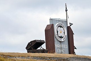
Pirates Cove Marine Provincial Park is a provincial park on De Courcy Island in British Columbia, Canada.

Plumper Cove Marine Provincial Park is a provincial park in British Columbia, Canada. The park is located on the northwest shore of Keats Island in Howe Sound, northwest of Vancouver, British Columbia.

Raft Cove Provincial Park is a provincial park in British Columbia, Canada, located south of San Josef Bay on northwestern Vancouver Island.

Rugged Point Marine Provincial Park is a provincial park in British Columbia, Canada, located at the southeast entrance to Kyuquot Sound on the west coast of Vancouver Island. It is remote and largely visited by kayakers.

Smuggler Cove Marine Provincial Park is a provincial park in British Columbia, Canada located approximately 16 kilometres (9.9 mi) west of Sechelt, a city on the Sunshine Coast.
Taylor Arm Provincial Park is a provincial park in British Columbia, Canada, located on the north side of Sproat Lake 23 km northwest of Port Alberni on Vancouver Island. Situated along Highway 4, the 71-hectare park has few services but provides group camping sites, undeveloped beaches, and day-use areas. The group camping site has pit toilets and a hand pump water supply, and is connected to the lake shore via a trail that passes under the highway.
Kyuquot Sound is a complex of coastal inlets, bays and islands on northwestern Vancouver Island in the Canadian province of British Columbia.
Allison Harbour, also formerly known as False Bay and False Schooner Passage, is a natural harbour on the Central Coast of British Columbia, Canada, extending north from Queen Charlotte Strait to the southeast of Bramham Island. It is the site of the former post office and steamer landing of Allison Harbour, British Columbia. The Allison Reefs lie in the entrance to the sound; Allison Cone (185m), which is nearby between Shelter Bay and Cape Caution, was named in association with Allison Harbour. It is now protected as part of Allison Harbour Marine Provincial Park.
Musket Island Marine Provincial Park is a provincial park in British Columbia, Canada, located on the west side of Nelson Island, at the mouth of Jervis Inlet and near Earl's Cove in the Sunshine Coast region.
The Leq'á:mel First Nation, formerly known as Lakahahmen First Nation, is a First Nations band government whose community and offices are located in the area near Deroche, British Columbia in the Fraser Valley region in Canada, about 12 kilometres east of the District of Mission. They are a member government of the Sto:lo Nation Chiefs Council, which is one of two tribal councils of the Sto:lo.
There are many lakes named Long Lake in British Columbia, Canada.
Drury inlet is an inlet in the Queen Charlotte Strait region of the Central Coast of British Columbia, Canada, extending west from Wells Passage to the northwest of North Broughton Island, northwest of the town of Port Hardy. Branching off to the northeast from the north side of the head of the inlet is Actaeon Sound.


