
The Liard River of the North American boreal forest flows through Yukon, British Columbia and the Northwest Territories, Canada. Rising in the Saint Cyr Range of the Pelly Mountains in southeastern Yukon, it flows 1,115 km (693 mi) southeast through British Columbia, marking the northern end of the Rocky Mountains and then curving northeast back into Yukon and Northwest Territories, draining into the Mackenzie River at Fort Simpson, Northwest Territories. The river drains approximately 277,100 km2 (107,000 sq mi) of boreal forest and muskeg.
Dixie Cove Marine Provincial Park, originally Dixie Cove Provincial Park, is a provincial park in British Columbia, Canada, located on the east side of Hohoae Island, which is just west of Fair Harbour in Kyuquot Sound on the West Coast of Vancouver Island.

Elk Falls Provincial Park is a provincial park in British Columbia, Canada. It is 1,807 hectares in size and is located at the east end of John Hart Lake on the northwest side of the city of Campbell River, on Vancouver Island.
Johnstone Creek Provincial Park is a provincial park in British Columbia, Canada, located west of the confluence of Rock Creek and the Kettle River and the town of Rock Creek. The park has a roughly 38 hectare area, and is near to the Crowsnest Highway.
Kootenay Lake Provincial Park is a provincial park in British Columbia, Canada. It encompasses five widely dispersed parks around Kootenay Lake: Kootenay Lake Provincial Park, Kootenay Lake Provincial Park, Kootenay Lake Provincial Park, Kootenay Lake Provincial Park, and Kootenay Lake Provincial Park.
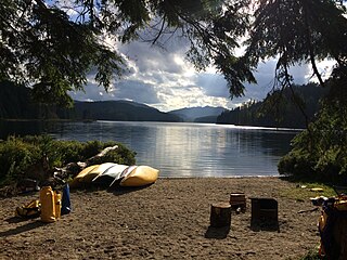
Main Lake Provincial Park is a provincial park on Quadra Island in British Columbia, Canada. Established in 1996 as Main Lakes Chain Park and renamed and expanded in 1997, the park encompasses a large wilderness area of six lakes with many diverse animal, bird and plant species. Opportunities for visitor observation and outdoor recreation include wilderness camping, canoeing, kayaking and hiking. Main Lake, Village Bay Lake and Mine Lake are connected by narrow, shallow marshes. Clear Lake, Stramberg Lake and Little Main Lake are accessible by hiking or rough portage.

Rebecca Spit Marine Provincial Park is a provincial park in British Columbia, Canada, located on the east side of Quadra Island, near the city of Campbell River.
Rock Bay Marine Provincial Park is a provincial park in British Columbia, Canada, located on the Inside Passage at the junction of Johnstone Strait and Discovery Passage. The park contains approximately 525 ha. Rock Bay is located on the shore of Vancouver Island, immediately south of East Thurlow Island.
Small Inlet Marine Provincial Park is a provincial park in British Columbia, Canada on the northwest side of Quadra Island, near the city of Campbell River.
Stuart River Provincial Park is a provincial park in British Columbia, Canada. It is located in two sections north and northwest of Vanderhoof along the Stuart River southeast of Stuart Lake and the city of Fort St. James. The upper section is located at 54°13′20″N124°00′00″W and comprises c.7391 ha. while the lower, eastern section is centred at 54°03′00″N123°37′00″W and comprises c.3390 ha. and is within the Greater Prince George area. The upper site, which is located around the confluence of the Stuart and Nechako Rivers, includes the site of Chinlac, a Dakelh village whose inhabitants were massacred and enslaved by the Tsilhqot'in of Anahim Lake c. 1745.
Tsintsunko Lakes Provincial Park is a 333-hectare provincial park in British Columbia, Canada, located south of the Deadman River between Kamloops (SE) and Bonaparte Lake (NW). It is located on the Bonaparte Plateau. It was established April 30, 1996.
Thurston Bay Marine Provincial Park is a provincial park on the northwest side of Sonora Island in British Columbia, Canada.
Taylor Arm Provincial Park is a provincial park in British Columbia, Canada, located on the north side of Sproat Lake 23 km northwest of Port Alberni on Vancouver Island. Situated along Highway 4, the 71-hectare park has few services but provides group camping sites, undeveloped beaches, and day-use areas. The group camping site has pit toilets and a hand pump water supply, and is connected to the lake shore via a trail that passes under the highway.
There are several lakes named Mud Lake within the Canadian province of Alberta.
Kyuquot Sound is a complex of coastal inlets, bays and islands on northwestern Vancouver Island in the Canadian province of British Columbia.
Allison Harbour, also formerly known as False Bay and False Schooner Passage, is a natural harbour on the Central Coast of British Columbia, Canada, extending north from Queen Charlotte Strait to the southeast of Bramham Island. It is the site of the former post office and steamer landing of Allison Harbour, British Columbia. The Allison Reefs lie in the entrance to the sound; Allison Cone (185m), which is nearby between Shelter Bay and Cape Caution, was named in association with Allison Harbour. It is now protected as part of Allison Harbour Marine Provincial Park.
The Pembroke Range is a small mountain range in southwestern British Columbia, Canada, between Loughborough Inlet and Phillips Arm. It has an area of 75 km2 and is a subrange of the Pacific Ranges which in turn form part of the Coast Mountains.
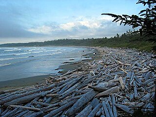
Long Beach is the largest and longest beach in the Pacific Rim National Park Reserve on the west coast of Vancouver Island, British Columbia, Canada. It is on Wickaninnish Bay between Tofino (NW) and Ucluelet (SE) and is adjoined by campgrounds and picnic areas. The Tofino-Ucluelet highway parallels the entirety of the beach. The beach's consistent surf, exposed to the open Pacific Ocean, established it as one of the earliest and most popular surfing locations in British Columbia.
There are many lakes named Long Lake in British Columbia, Canada.
The Fawnie Range is a small hill-range located to the south of the Ootsa Lake reservoir and to the north of the West Road River in the Nechako Plateau region of the Central Interior of British Columbia, Canada. The northwest part of the park is within Entiako Provincial Park and includes Mount Swannell,, one of the range's main summits, overlooking Natalkuz Lake from the south. Other named summits include Tutial Mountain, Fawnie Dome and Fawnie Nose, the highest summit in the range.


