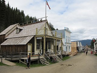
Barkerville was the main town of the Cariboo Gold Rush in British Columbia, Canada, and is preserved as a historic town. It is located on the north slope of the Cariboo Plateau near the Cariboo Mountains 80 kilometres (50 mi) east of Quesnel. BC Highway 26, which follows the route of the Cariboo Wagon Road, the original access to Barkerville, goes through it.

Chilliwack is a city of about 100,000 people and 261 km2 (100 sq mi) in the Canadian province of British Columbia. It is located about 100 km (62 mi) east of the City of Vancouver in the Fraser Valley. The enumerated population is 93,203 in the city and 113,767 in the greater metropolitan area.
Kaleden is an unincorporated community about midway along the western shore of Skaha Lake in the Okanagan region of south central British Columbia. Adjacent to BC Highway 97, the locality is by road about 13 kilometres (8 mi) south of Penticton.

Fort Langley is a village community in Township of Langley, British Columbia, Canada. It has a population of approximately 3,400 people. It is the home of Fort Langley National Historic Site, a former fur trade post of the Hudson's Bay Company. Lying on the Fraser River, Fort Langley is at the northern edge of the Township of Langley.
The Harrison River is a short but large tributary of the Fraser River, entering it near the community of Chehalis, British Columbia, Canada. The Harrison drains Harrison Lake and is the de facto continuation of the Lillooet River, which feeds the lake.
Babine Lake Marine Park is on Babine Lake, which borders the Skeena and Omineca regions of central British Columbia. This provincial park comprises six separate sites around the lake. Vehicle access to the lake, via BC Highway 16 and Nilkitkwa forestry service road, is by road about 105 kilometres (65 mi) northeast of Smithers; via BC Highway 16 and Central Babine Lake Highway, is about 132 kilometres (82 mi) east of Smithers; or via Babine Lake Road, is about 20 kilometres (12 mi) northeast of Burns Lake.

Helliwell Provincial Park is a provincial park in British Columbia, Canada located on a headland at the northeast end of Hornby Island.

Juan de Fuca Provincial Park is a provincial park located on the west coast of Vancouver Island in British Columbia, Canada. The park was established on April 4, 1996 by combining three former parks — China Beach, Loss Creek, and Botanical Beach — into one provincial park. It is the location of the majority of the Juan de Fuca Marine Trail, which is a southern compliment to the West Coast Trail within Pacific Rim National Park Reserve.
Kitsumkalum Park is in the Skeena region of west central British Columbia, Canada. This provincial park is on the east shore of the Kitsumkalum River at the foot of Kitsumkalum Lake. On Kalum Lake Road, the locality is by road about 29 kilometres (18 mi) north of Terrace.

The District of Kent is a district municipality located 116 kilometres (72 mi) east of Vancouver, British Columbia. Part of the Fraser Valley Regional District, Kent consists of several communities, the largest and most well-known being Agassiz—the only town in the municipality—Harrison Mills, Kilby, Mount Woodside, Kent Prairie, Sea Bird Island and Ruby Creek. Included within the municipality's boundaries are several separately-governed Indian reserves, including the Seabird Island First Nation's reserves on and around the island of the same name.

Harrison Mills, formerly Carnarvon and also Harrison River, is an agricultural farming and tourism-based community in the District of Kent west of Agassiz, British Columbia. The community is a part of the Fraser Valley Regional District. Harrison Mills is home to the British Columbia Heritage Kilby Museum and Campground.

Mara Lake is a lake in the Shuswap Country region of south central British Columbia, Canada. To the west is Hyde Mountain and east is Morton Peak. The outlet of the Shuswap River forms the upper reaches. The lower end enters the narrows at Sicamous and flows into Shuswap Lake. The northern end of Mara Lake is by road about 73 kilometres (45 mi) west of Revelstoke, 140 kilometres (87 mi) east of Kamloops, and 75 kilometres (47 mi) north of Vernon.

Three Valley Gap is an unincorporated community at the eastern end of Three Valley Lake in the Shuswap Country region of southeastern British Columbia. On BC Highway 1, the locality is by road about 21 kilometres (13 mi) southwest of Revelstoke, and 51 kilometres (32 mi) northeast of Sicamous.

Cottonwood, including the Cottonwood Ranch and Cottonwood House, is an unincorporated settlement in the North Cariboo region of the Central Interior of British Columbia, Canada. Originally a ranch, it is located in the northern Cariboo Plateau, just 8 km northwest of Coldspring House, which is at the confluence of the Swift River and Lightning Creek, which is the beginning of the Cottonwood River. Lightning Creek was one of the more famous of the gold-bearing creeks of the Cariboo Gold Rush.
The Sumas First NationSumalh or Sumas Indian Band is a band government of the Sto:lo people located in the Upper Fraser Valley region, at the community of Kilgard a.k.a. Upper Sumas, part of Abbotsford, British Columbia, Canada. They are a member government of the Sto:lo Nation tribal council.
Harrison Hill (622m) is a small mountain located at the confluence of the Harrison and Fraser Rivers in the Lower Mainland region of British Columbia, Canada. Harrison Knob (~225m) is a prominent shoulder to the east of the main peak of Harrison Hill. Harrison Hill and Harrison Knob are on the north side of the Fraser opposite Chilliwack, Harrison Knob overlooks the confluence directly, Harrison Hill itself separates the Fraser downstream from that confluence and overlooks on its north Harrison Bay, a large, shallow lake-like sidewater of the Harrison River, while at its western foot is the community of Lake Errock. At its eastern foot, just below Harrison Knob, had been the formerly large sawmill town of Harrison Mills, which spanned both sides of the Harrison and was served by the mainline of the Canadian Pacific Railway, which runs along the north side of the mountain's base. The Indian Reserves of the Scowlitz First Nation are at the western end of Harrison Bay and at its outlet at its eastern end, while the reserve of the Chehalis First Nation is along its north shore, and Kilby is on its east shore.
Harrison Bay is a lake-like expansion of the Harrison River, located west of its main course adjacent to the communities of Chehalis and Harrison Mills in the Canadian province of British Columbia. Extremely shallow, the bay outlets to the Fraser at Harrison Mills, where in pre-gold rush times there had been a "riffle", which was dredged to enable easier steamer traffic to Harrison Lake and Port Douglas. The bay has been used as a log sort but is primarily recreational in use today, with the Scowlitz Indian Band running a beach and campground at its western end, on Squawkum Creek Indian Reserve No. 3, which is at the southwest corner of Harrison Bay. Between it and the Fraser lies Harrison Hill, known in Upriver Halkomelem as Qithyll, which is an ancient burial ground currently under investigation by the First Nation in a joint effort with Simon Fraser University's archaeology department.. Adjacent to Kilby Provincial Park and the site of Harrison Mills are Williams Indian Reserve No. 2 and Scowlitz Indian Reserve No. 1
Hardy Mountain Doukhobor Village is in the Boundary region of south central British Columbia. The former Doukhobor community is about 4.3 kilometres (2.7 mi) northwest of Grand Forks on Hardy Mountain Rd.
Chilliwack is a city made up of several amalgamated villages and communities. The urban core has a decidedly north–south axis bisected by the Trans-Canada Highway. The city is bounded in north by the Fraser River, in the east by the Eastern Hillsides, in the south by the Canada-U.S. border, and in the west by the Vedder Canal.

Brisco is an unincorporated community on the east shore of the Columbia River, in the East Kootenay region of southeastern British Columbia. The locality, on BC Highway 95, is by road about 172 kilometres (107 mi) north of Cranbrook and 75 kilometres (47 mi) southeast of Golden.


