Harrison Mills, British Columbia

Last updated

Harrison Mills
Unincorporated community
Harrison River at Highway 7 bridge facing North.jpg
Harrison River at Highway 7 bridge facing north
Nickname: 
Kilby
Harrison Hot Springs, British Columbia Location.png
Location of Harrison Mills
Coordinates: 49°14′30″N121°56′45″W / 49.24167°N 121.94583°W / 49.24167; -121.94583
Country Flag of Canada (Pantone).svg  Canada
Province Flag of British Columbia.svg  British Columbia
Region Fraser Valley/Lower Mainland
Regional District Fraser Valley Regional District
Founded1859
Population
 (2016)
  Total484
Time zone UTC-8 (PST)
  Summer (DST) PDT
Area code(s) 604, 778
Website http://www.kilby.ca

Harrison Mills, formerly Carnarvon and also Harrison River, is an agricultural farming and tourism-based community in the District of Kent west of Agassiz, British Columbia. The community is a part of the Fraser Valley Regional District. Harrison Mills is home to the British Columbia Heritage Kilby Museum and Campground.

Contents

History

First Nations history

Chehalis First Nations 975.008.025 First Nations.JPG
Chehalis First Nations

Harrison Bay is the home of the Scowlitz (Scaulits) people, whose main reserve is on the bay's western shore, across from Harrison Mills, and also of the Sts'Ailes or Chehalis people, whose reserve is located on the north side of the bay along the lower Harrison River and around that river's confluence with its tributary, the Chehalis. The Scowlitz and Chehalis peoples once had large and famously-carved longhouse villages, long since destroyed by the encouragement of missionaries. An archaeological site on the Harrison Mills side of the bay, the Scowlitz Mounds, also known as the Fraser Valley Pyramids, is under investigation by Simon Fraser University and the Scowlitz First Nation and represent an unusual period in the anthropological and cultural history of the Fraser Valley. The Scowlitz are Halqemeylem-speaking and are part of the Sto:lo cultural group, while the Sts'ailes (Chehalis) identify themselves separately and speak a dialect of Halqemeylem that has similarities with the Lower Lillooet River dialect of St'at'imcets (Ucwalmicwts).

The dialect spoken by the Sts'Ailes, whose name means "beating heart", includes the word sesqac, which is the source of the English word "sasquatch". The vicinity of Harrison Bay, Harrison Mills and the lower Harrison River is reputed to have the greatest number and density of sasquatch sightings worldwide. The sasquatch is the emblem of the Chehalis First Nation and is sacred in Sts'Ailes culture. The opening of Fort Langley in 1827 downriver began changing the traditional patterns of life for the Scowlitz and Chehalis by the introduction of new goods and also an end to raids by the Euclataws Kwakwaka'wakw (Southern Kwakiutl) of Cape Mudge and other northern coastal tribes.

Settlement and colonization

1859–1914

Henry Herbert, 4th Earl of Carnarvon 4th Earl of Carnarvon.jpg
Henry Herbert, 4th Earl of Carnarvon

In 1859, Governor James Douglas named the meeting place of the Harrison and Fraser rivers Carnarvon in honour of Henry Herbert Molyneux, the fourth Earl of Carnarvon. At the time of its naming, the town consisted of one crude hotel. Partly because of this, the name never caught on and the town-to-be never grew as hoped. For a time, official maps of the area duly recorded the name as Carnarvon but almost all newspapers and diaries referred to it as Harrisonmouth.

In just a few weeks, during the Fraser Canyon Gold Rush of 1858, 30,000 men travelled up the Fraser River to the Fraser Canyon, upstream from Hope. Many stopped along the way, with sandbars along the Fraser near Harrison Mills and throughout the Fraser Valley turned over by prospectors. Gold was found around Harrison Mills and as far downstream as the present site of Mission, but extraction was profitable only above Hope.

The first settlers of note, and perhaps the most important, were Captain William Menten and his wife Emma who arrived in 1890. Emma Menten became the owner of the aforementioned hotel that had been expanded over the years. The next prominent family to arrive was that of Charles Fenn Pretty who built a spacious lodge in 1903. Finally, Joseph Martin built a large sawmill in 1892 beside the railway. The construction of this mill would move the townsite away from Lot 10A which was bordered on all sides by the Scowlitz reserve and towards Harrison Bay, a move that would have significant repercussions.

It was at this time that Emma Menten moved her store from Lot 10A to a site immediately east of the Martin mill in order to compete with a new store by the railway opened by Laurie and David Galbraith. Meanwhile, Captain Menten built a small sternwheeler called the Minto to carry passengers between Chilliwack and Harrison Mills. This increased the traffic coming across the Fraser River from Chilliwack and spurred business in the town.

The Rat Portage Mill, early 1900s. RatPortageMill.jpg
The Rat Portage Mill, early 1900s.

Quite suddenly, two new mills were constructed: a shingle mill, which would remain in operation until 1942, and a larger sawmill that replaced the old Martin mill, bought by the Tretheweys. James Trethewey sr. was an ambitious man with big plans for the enterprise. In November 1899, the Harrison River Mills Timber and Trading Company was incorporated. Trethewey planned to run the business jointly with his two sons, as well as Thomas Jackson of Chilliwack, T.A. Cuddy and Frank Boyd. With these mills came a large influx of people. A school and church were built in 1901 to meet the needs of the expanding town. Before this, children had to cross the river by boat to go to school; this is how Maud Menten, one of Harrison Mills's most famous residents, was educated.

In June 1903, the Tretheweys decided to sell half-interest in their mill to the Rat Portage Lumber Company but before the contracts could be signed and the cheque handed over, a fire swept through the millsite, destroying the buildings, machinery and lumber. The company's losses were estimated at $50,000 above its insurance coverage. As a result of this, the Rat Portage company bought the entire holdings of the Tretheweys in October 1903. When the new mill was opened in 1909, it was one of BC's largest sawmills. The Chilliwack Progress estimated the mill's daily capacity at 100,000 to 150,000 feet.

It was in these adjoining years of relative inactivity in the sawmill that Thomas and Eliza Kilby built and opened their famous store. They bought the two adjoining lots from Emma and Robert (son) Menton in 1906, building in two stages. The store itself was built in 1906, while the hotel was built in 1907, doubling the size of the building. In direct competition was the Rat Portage store and boarding house, built only six months after the T. Kilby General Store opened.

In 1910, a blow was struck to the business in Harrison Mills. The B.C. Electric Line opened on October 3, 1910, serving passengers going between Chilliwack and New Westminster. Much of the town's business at that point was Chilliwack residents wanting to travel by rail, but after construction, westbound travelers would switch to the new route. On October 10, 1910, Eliza Kilby closed the hotel, leaving it open as a boarding house for many years. Finally, the CNR was opened in 1915 passing through Chilliwack, offering a direct route to eastern Canada. Harrison Mills' role as a traffic junction was completely finished.

1914–1950

Bridge Guard at Harrison Mills MenfromDukeofConnaughtsOwnMilitary.JPG
Bridge Guard at Harrison Mills

The outbreak of war in 1914 delayed all chance of recovery. Somewhat surprisingly, the government stationed a ten-man bridge guard from the Duke of Connaught's Own Rifles at Harrison Mills for the duration of the war. They were stationed as a security precaution against sabotage to the CPR line, the vital transcontinental link.

The end of the war brought demands for improvement and development. There was an expectation that the Rat Portage mill would be opening once more and transform the town into a busy commercial centre once again. The company began to make plans early in 1921, when they offered to buy land from Thomas Kilby. However, it ultimately decided to pull out of the town altogether, to concentrate on its mill in Vancouver. The machinery was sold and the buildings left vacant, until a fire in 1930 claimed most of what was left. The fire was so intense that the railway had to be closed for a day, delaying Prime Minister Mackenzie King himself in Agassiz while repairs were made.

However, the old shingle mill continued to run and employ a fair number of people. But despite this, the town settled back into a quiet farming existence.

Through the 1920s, the main concern of residents was the construction of a major highway connection. After a strong showing on behalf of residents of Harrison Mills in 1912, the Kent Municipal Council decided to construct the road over Mount Woodside and through the Harrison Mills floodplain. However, it was not until twelve years later that the construction was started. In 1924, the project began after numerous petitions by Acton Kilby (son of Thomas and Eliza who was by now running the store). Upon completion, the road was not as useful as hoped. It took Acton Kilby four and a half hours to drive to Vancouver.

The next major issue was dyking along the Harrison and Fraser Rivers. In 1921, Thomas Kilby began to recruit his neighbours to sign a petition to the Municipality of Kent urging construction. However, a rival petition circulated by James Duncan upset the Kilby petition and he did not manage to collect the necessary 51% of the property owners. By 1925, the farmers had organized in a committee that constructed a private dyke that consisted of a 3' wall from the Bateson Slough to the CPR tracks at the Harrison Mills railway station.

Geography

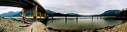
Harrison Mills is located on a floodplain at the western foot of Mount Woodside at the outlet of Harrison Bay, a large lake-like backwater of the Harrison River just before that river's confluence with the Fraser.

See also

Related Research Articles

<span class="mw-page-title-main">Fraser River</span> River in British Columbia, Canada

The Fraser River is the longest river within British Columbia, Canada, rising at Fraser Pass near Blackrock Mountain in the Rocky Mountains and flowing for 1,375 kilometres (854 mi), into the Strait of Georgia just south of the City of Vancouver. The river's annual discharge at its mouth is 112 cubic kilometres (27 cu mi) or 3,550 cubic metres per second (125,000 cu ft/s), and each year it discharges about 20 million tons of sediment into the ocean.

<span class="mw-page-title-main">Fraser Valley</span> Geographical region in British Columbia

The Fraser Valley is a geographical region in southwestern British Columbia, Canada and northwestern Washington State. It starts just west of Hope in a narrow valley encompassing the Fraser River and ends at the Pacific Ocean stretching from the North Shore Mountains, opposite the city of Vancouver BC, to just south of Bellingham, Washington.

<span class="mw-page-title-main">Yale, British Columbia</span> Town in British Columbia, Canada

Yale is an unincorporated town in the Canadian province of British Columbia, which grew in importance during the Fraser Canyon Gold Rush.

<span class="mw-page-title-main">Stó꞉lō</span> Indigenous group of British Columbia

The Stó꞉lō, alternately written as Sto꞉lo, Stó:lô, or Stó:lõ, historically as Staulo or Stahlo, and historically known and commonly referred to in ethnographic literature as the Fraser River Indians or Lower Fraser Salish, are a group of First Nations peoples inhabiting the Fraser Valley and lower Fraser Canyon of British Columbia, Canada, part of the loose grouping of Coast Salish nations. Stó꞉lō is the Halqemeylem word for "river", so the Stó꞉lō are the river people. The first documented reference to these people as "the Stó꞉lō" occurs in Catholic Oblate missionary records from the 1880s. Prior to this, references were primarily to individual tribal groups such as Matsqui, Ts’elxweyeqw, or Sumas.

The Chehalis River is located in the southwest corner of British Columbia, Canada near the city of Chilliwack. It flows south-eastward out of the Douglas Ranges of the Coast Mountains, draining into the Harrison River.

<span class="mw-page-title-main">Harrison Hot Springs</span> Village in British Columbia, Canada

Harrison Hot Springs is a village located at the southern end of Harrison Lake in the Fraser Valley of British Columbia. It is a member of the Fraser Valley Regional District; its immediate neighbour is the District of Kent, which includes the town of Agassiz. It is a resort community known for its hot springs and has a population of just over 1500 people. It is named after Benjamin Harrison, a former deputy governor for the Hudson's Bay Company.

<span class="mw-page-title-main">Harrison Lake</span> Lake in British Columbia, Canada

Harrison Lake is the largest lake in the southern Coast Mountains of Canada, being about 250 square kilometres (95 mi²) in area. It is about 60 km (37 mi) in length and at its widest almost 9 km (5.6 mi) across. Its southern end, at the resort community of Harrison Hot Springs, is c. 95 km east of downtown Vancouver. East of the lake are the Lillooet Ranges while to the west are the Douglas Ranges. The lake is the last of a series of large north-south glacial valleys tributary to the Fraser along its north bank east of Vancouver, British Columbia. The others to the west are the Chehalis, Stave, Alouette, Pitt, and Coquitlam Rivers.

<span class="mw-page-title-main">Harrison River</span> River in British Columbia, Canada

The Harrison River is a short but large tributary of the Fraser River, entering it near the community of Chehalis, British Columbia, Canada. The Harrison drains Harrison Lake and is the de facto continuation of the Lillooet River, which feeds the lake.

<span class="mw-page-title-main">Douglas Ranges</span> Subrange of mountains in British Columbia, Canada

The Douglas Ranges are a subrange of the Pacific Ranges of the Coast Mountains of the Canadian province of British Columbia, about 70 km (43 mi) east of downtown Vancouver, north of the Fraser River and between the valleys of Stave and Harrison Lakes. They are approximately 4,900 km2 (1,900 sq mi) in area. Their highest peak is Mount Robertson 2,252 m (7,388 ft), at the northwest limit of the range.

<span class="mw-page-title-main">Kilby Provincial Park</span> Provincial park in British Columbia, Canada

Kilby Provincial Park is a provincial park in British Columbia, Canada. Kilby Park is located in Harrison Mills, on the Harrison River overlooking Harrison Bay in the Upper Fraser Valley of southwestern British Columbia. It comprises 3 hectares with 30 campsites and a boat launch. The park offers a sandy summer beach and fall/winter viewing of bald eagles and migrating trumpeter swans from Alaska.

<span class="mw-page-title-main">Kent, British Columbia</span> District municipality in British Columbia, Canada

The District of Kent is a district municipality located 116 kilometres (72 mi) east of Vancouver, British Columbia. Part of the Fraser Valley Regional District, Kent consists of several communities, the largest and most well-known being Agassiz—the only town in the municipality—Harrison Mills, Kilby, Mount Woodside, Kent Prairie, Sea Bird Island and Ruby Creek. Included within the municipality's boundaries are several separately-governed Indian reserves, including the Seabird Island First Nation's reserves on and around the island of the same name.

The Giscome Portage was a portage between the Fraser River and Summit Lake, which connected with the river route to the Peace Country via Finlay Forks. BC Parks administers the Giscome Portage Trail. The Huble Homestead Historic Site, at the south end, is on the Fraser River, 40 kilometres (25 mi) north of Prince George and 6 kilometres (3.7 mi) off Highway 97.

The Sts'ailes are an indigenous people from the Lower Mainland region of British Columbia, Canada.

<span class="mw-page-title-main">Steamboats of Grays Harbor and Chehalis and Hoquiam Rivers</span>

Steamboats operated on Grays Harbor, a large coastal bay in the State of Washington, and on the Chehalis and Hoquiam rivers which flow into Grays Harbor near Aberdeen, a town on the eastern shore of the bay.

McGillivray, formerly McGillivray Falls, is an unincorporated recreational community on the west shore of Anderson Lake, just east of midway between the towns of Pemberton and Lillooet, British Columbia, Canada, in that province's southwest Interior.

<span class="mw-page-title-main">Andersonia, California</span> Unincorporated community in California, United States

Andersonia is an unincorporated community in Mendocino County, California. It is located near U.S. Route 101 on the South Fork of the Eel River 1 mile (1.6 km) north-northwest of Piercy, at an elevation of 541 feet.

The Sq'éwlets First Nation (Scowlitz) is the band government of Skaulits subgroup of the Stó:lō people located on Harrison Bay in the Upper Fraser Valley region between Chehalis (E) and Lake Errock, British Columbia, Canada (W). They are a member government of the Stó:lō Tribal Council.

Harrison Hill (622m) is a small mountain located at the confluence of the Harrison and Fraser Rivers in the Lower Mainland region of British Columbia, Canada. Harrison Knob (~225m) is a prominent shoulder to the east of the main peak of Harrison Hill. Harrison Hill and Harrison Knob are on the north side of the Fraser opposite Chilliwack, Harrison Knob overlooks the confluence directly, Harrison Hill itself separates the Fraser downstream from that confluence and overlooks on its north Harrison Bay, a large, shallow lake-like sidewater of the Harrison River, while at its western foot is the community of Lake Errock. At its eastern foot, just below Harrison Knob, had been the formerly large sawmill town of Harrison Mills, which spanned both sides of the Harrison and was served by the mainline of the Canadian Pacific Railway, which runs along the north side of the mountain's base. The Indian Reserves of the Scowlitz First Nation are at the western end of Harrison Bay and at its outlet at its eastern end, while the reserve of the Chehalis First Nation is along its north shore, and Kilby is on its east shore.

Harrison Bay is a lake-like expansion of the Harrison River, located west of its main course adjacent to the communities of Chehalis and Harrison Mills in the Canadian province of British Columbia. Extremely shallow, the bay outlets to the Fraser at Harrison Mills, where in pre-gold rush times there had been a "riffle", which was dredged to enable easier steamer traffic to Harrison Lake and Port Douglas. The bay has been used as a log sort but is primarily recreational in use today, with the Scowlitz Indian Band running a beach and campground at its western end, on Squawkum Creek Indian Reserve No. 3, which is at the southwest corner of Harrison Bay. Between it and the Fraser lies Harrison Hill, known in Upriver Halkomelem as Qithyll, which is an ancient burial ground currently under investigation by the First Nation in a joint effort with Simon Fraser University's archaeology department.. Adjacent to Kilby Provincial Park and the site of Harrison Mills are Williams Indian Reserve No. 2 and Scowlitz Indian Reserve No. 1

References

Commons-logo.svg Media related to Harrison Mills at Wikimedia Commons