
The Liard River of the North American boreal forest flows through Yukon, British Columbia and the Northwest Territories, Canada. Rising in the Saint Cyr Range of the Pelly Mountains in southeastern Yukon, it flows 1,115 km (693 mi) southeast through British Columbia, marking the northern end of the Rocky Mountains and then curving northeast back into Yukon and Northwest Territories, draining into the Mackenzie River at Fort Simpson, Northwest Territories. The river drains approximately 277,100 km2 (107,000 sq mi) of boreal forest and muskeg.
Liard River Hot Springs Provincial Park is a provincial park in British Columbia, Canada. It is home to the second largest natural hot springs in Canada, after Deer River Hot Springs 15 km to the north east. It is a natural river of hot water rather than a spring fed man made pool. The park is part of the larger Muskwa-Kechika Management Area. The community of Liard River, British Columbia is located nearby.
Bishop River Provincial Park is a provincial park in the Pacific Ranges of the Coast Mountains on the Mainland of British Columbia, Canada, located southwest of and adjoining Ts'yl-os Provincial Park."Bishop River Park". BC Geographical Names. It lies along the upper course of the Bishop River, the main tributary of the Southgate River, from the Bishop's source at the western side of the Lillooet Icecap to midway along its course above its confluence with the Southgate. The park is 19,947 ha. in size. There are no roads or trails in the park although a forest service road from Waddington Harbour at the head of Bute Inlet leads up the Southgate to within a few miles of the park boundary.
Cariboo River Provincial Park is a provincial park in British Columbia, Canada, located between Barkerville and Likely in the upper Cariboo River basin.
Coquihalla River Provincial Park is a provincial park in British Columbia, Canada, located 25 km (16 mi) north of the town of Hope on BC Highway 5 adjacent to the Coquihalla River.

Englishman River Falls Provincial Park is a provincial park in British Columbia, Canada. It is located west of Parksville and borders the small community of Errington on Vancouver Island.
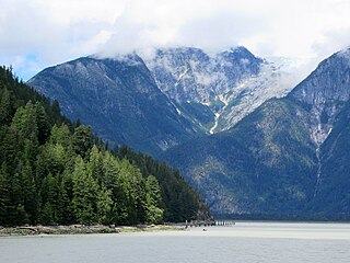
Homathko Estuary Provincial Park is a provincial park in British Columbia, Canada, located at the head of Bute Inlet surrounding the mouth of the Homathko River in the Pacific Ranges of the Coast Mountains.
Nicolum River Provincial Park, formerly Nicolum Provincial Park, is a provincial park in British Columbia, Canada, located at the confluence of the Nicolum and Coquihalla Rivers near the town of Hope. The park is a Class A, category 6 Provincial Park.
Upper Seymour River Provincial Park is a provincial park in British Columbia, Canada. Located in an isolated area in the interior of the province, 40 kilometres north of the community of Seymour Arm. It protects at the headwaters of the Seymour River, which is the major drainage system into the Seymour Arm of Shuswap Lake.
Pine River Breaks Provincial Park is a provincial park in British Columbia, Canada in the Peace River Lowland between the communities of East Pine and Chetwynd.
Prophet River Wayside Provincial Park is a provincial park in British Columbia, Canada. It is located along the Prophet River, by the Alaska Highway, between the localities of Trutch and Prophet River. Originally created as a Provincial Recreation Area in 1977 with an area of 707 acres (2.86 km2), it was designated a provincial park in 1999 with an area of 111 hectares.

Rearguard Falls Provincial Park is a provincial park in British Columbia, Canada, protecting Rearguard Falls on the Fraser River. It is located just above its emergence into the Rocky Mountain Trench near the community of Tete Jaune Cache. The park is easily accessed via BC Highway 16. Rearguard Falls is one of only two waterfalls on the 1,375 km (854 mi)-long Fraser River; the other is a few kilometres upstream at Overlander Falls. Rearguard Falls offers a view of the return of Chinook salmon for spawning.

Tsútswecw Provincial Park is a provincial park in British Columbia, Canada, located northeast of Kamloops and northwest of Salmon Arm. It stretches along the banks of the Adams River, between the south end of Adams Lake and the western portion of Shuswap Lake.
Scatter River Old Growth Provincial Park is a provincial park in British Columbia, Canada, located on the Liard River downstream from Liard River Hot Springs Provincial Park and Liard River Corridor Provincial Park and Protected Area. The park includes the Grand Canyon of the Liard, a 30 km stretch of canyon and whitewater between the Toad and Trout River converges with the Liard. The park includes high upland plateau and muskeg as well as stands of old growth spruce forests. Established in 1999, the park is c.1140 ha. in area.

Sooke Potholes Provincial Park is a 7.28 hectare provincial park in British Columbia, Canada. It is adjacent to the Sooke River and Sooke Potholes Regional Park, near Victoria, British Columbia. Intended primarily to provide access to the Sooke River and the associated potholes, it also offers wildlife viewing and other day-use activities.
Spatsizi Plateau Wilderness Provincial Park is located in the northern portion of British Columbia, Canada, approximately 698, 659 hectares and encompasses the Spatsizi River and Gladys Lake Ecological Reserve. The park is a designated protected area that is intended for the conservation and research on caribou, grizzly bears, fish, and other wildlife species populations. Before the provincial park's establishment in 1975, the area was a historical hunting ground for local Indigenous communities like the Tahltan First Nations. It is the second largest provincial park in British Columbia.

The Stikine River Provincial Park is a provincial park in British Columbia. The park covers a total area of approximately 217,000 hectares. The main feature of the Stikine River Provincial Park is a portion of the Stikine River known as "The Grand Canyon". This portion of the river is approximately eighty kilometers long and runs through a canyon that has been created from the river cutting through the rock that now forms the walls of the "canyon".
Tudyah Lake Provincial Park is a provincial park in British Columbia, Canada. The park is approximately 56 km south of Mackenzie, BC on Highway 97.

