Collinson Point Provincial Park

Last updated
Collinson Point Provincial Park
Shoreline with Arbutus, Collinson Point.jpg
Canada Vancouver Island relief map.jpg
Red pog.svg
Canada British Columbia relief location map.jpg
Red pog.svg
Location Galiano Island, British Columbia, Canada
Coordinates 48°51′42″N123°21′42″W / 48.86167°N 123.36167°W / 48.86167; -123.36167
Area23.68 hectares (58.5 acres)
Designation Provincial Park
Created2004 (2004)
Governing body BC Parks
Website Collinson Point Provincial Park
Collinson Point Provincial Park

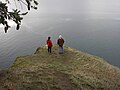
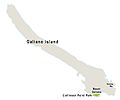
Collinson Point Provincial Park is a provincial park on Galiano Island, British Columbia, Canada. It is located between Mount Galiano and the western approaches to Active Pass. The area is 23.68 hectares (58.5 acres), with approximately 500 metres of waterfront.

Contents

The park shares a long common border with Mount Galiano Community Park, of which it is an extension. Most of the remaining boundary is constituted by the shoreline.

History

The park was established in 2004, by acquisition from a private owner. Prior to 1988, the property had belonged to the forest company MacMillan Bloedel as part of its Galiano holdings, which itself had previously belonged to the Vancouver Coal Mining and Land Company (who acquired the land by colonial grant). MacMillan Bloedel built the Phillimore Point Trail which passes through the Park.

Geology

The main feature is soft sandstone of the Upper Cretaceous Nanaimo Group, frequently exposed, otherwise with a thin overburden of podzolic soil. The sandstone is distinguished by its flowing, rounded forms; these appear to be volcanic bubbles but are actually the result of erosion by weathering. There are also areas of shale. The topography is steep, with occasional small plateaux; the park is basically the sheer southern slope of Mount Galiano.

Ecology

Flora

The vegetation is typical of south-facing slopes in the Coastal Douglas-fir zone, intergrading with Garry Oak and Arbutus. Western Red Cedar (Thuja plicata) is abundant in the areas shaded by cliffs, and grassland is present in coastal areas. The grasslands and open woodlands have an abundance of wildflowers typical of this zone, notably fairy slipper (Calypso bulbosa) and Collinsia parviflora .

Fauna

The turbulent waters of Active Pass are a major source of food for marine life. Seals can be found here, as well as bald eagles and cormorants. Because the park is part of an integral forest area, upland wildlife is also abundant, notably black-tailed deer and sooty grouse.

Tourism

The easiest public access is by a trail that starts at the Mt. Galiano parking lot near the end of Active Pass Drive. The Galiano Trails Society has an agreement with the private property owner the trail crosses to allow public access to the park. The trail is signposted. There are no campsites or other facilities. Another approach is by kayak, and this is quite popular.

Related Research Articles

<span class="mw-page-title-main">Pacific Rim National Park Reserve</span> National park reserve in British Columbia, Canada

Pacific Rim National Park Reserve is a 511 km2 (197 sq mi) national park located in British Columbia, Canada, which comprises three separate regions: Long Beach, the Broken Group Islands, and the West Coast Trail. It is located in the Pacific Coast Mountains, which are characterized by rugged coasts and temperate rainforests.

<span class="mw-page-title-main">Gulf Islands National Park Reserve</span> National park reserve in British Columbia, Canada

Gulf Islands National Park Reserve is a national park located on and around the Gulf Islands in British Columbia, Canada. In the National Parks System Plan, this park provides representation of the Strait of Georgia Lowlands natural region, the only place in Canada with a Mediterranean climate of dry, sunny summers and mild, wet winters, the result of a rain shadow effect from surrounding mountains between the region and the ocean. It has similar dominant vegetation as the Pacific Northwest, such as coastal Douglas-fir, western red cedar, shore pine, Pacific dogwood, bigleaf maple, and red alder, but also contains the northern extent of some of the more drought tolerant trees such as Garry oak and Arbutus. The park was created in 2003 as the fortieth national park. It covers 36 square kilometres (14 sq mi) of area on 16 islands and more than 30 islets, reefs and surrounding waters, making it the sixth smallest national park in Canada.

<span class="mw-page-title-main">North Cascades</span> Mountain range in Canada and the United States

The North Cascades are a section of the Cascade Range of western North America. They span the border between the Canadian province of British Columbia and the U.S. state of Washington and are officially named in the U.S. and Canada as the Cascade Mountains. The portion in Canada is known to Americans as the Canadian Cascades, a designation that also includes the mountains above the east bank of the Fraser Canyon as far north as the town of Lytton, at the confluence of the Thompson and Fraser Rivers.

<span class="mw-page-title-main">Galiano Island</span> Island in British Columbia, Canada

Galiano Island is one of the Southern Gulf Islands located between Vancouver Island and the Lower Mainland of British Columbia, Canada. Located on the west side of the Strait of Georgia, the island is bordered by Mayne Island to the southeast, Salt Spring Island to the west and Valdes Island to the northwest. Galiano is part of the Capital Regional District Electoral Area G, and has a permanent population of 1,396 inhabitants as of 2021.

<span class="mw-page-title-main">Mount Tamalpais</span> Mountain in California, United States

Mount Tamalpais, known locally as Mount Tam, is a peak in Marin County, California, United States, often considered symbolic of Marin County. Much of Mount Tamalpais is protected within public lands such as Mount Tamalpais State Park, the Marin Municipal Water District watershed, and National Park Service land, such as Muir Woods.

<span class="mw-page-title-main">MacMillan Bloedel</span> Forest company in British Columbia

MacMillan Bloedel Limited was a Canadian forestry company headquartered in Vancouver, British Columbia. The company was formed in 1951 as MacMillan and Bloedel through the merger of Bloedel, Stewart and Welch with the H. R. MacMillan Export Company. MacMillan and Bloedel then merged in 1959 with the Powell River Company to form MacMillan, Bloedel and Powell River, before adopting its final name in 1966. It was acquired by Weyerhaeuser in 1999.

<span class="mw-page-title-main">Carmanah Walbran Provincial Park</span> Provincial park on Vancouver Island in British Columbia, Canada

Carmanah Walbran Provincial Park, originally Carmanah Pacific Provincial Park, is a remote wilderness park located inside traditional Ditidaht First Nation ancestral territory. The park covers a land area of 16,450 ha (63.5 sq mi) immediately adjacent to Pacific Rim National Park Reserve's West Coast Trail on the south-western, coastal terrain of Vancouver Island. The provincial park comprises the entire drainage of Carmanah Creek, and a good portion of the lower Walbran River drainage, both of which independently empty into the Pacific Ocean. The park is named after the Anglicized diitiid?aatx word kwaabaaduw7aa7tx, or Carmanah, meaning "as far up as a canoe can go" and John Thomas Walbran, a colonial explorer and ship's captain. Access to the park is by gravel logging road from Port Alberni, Lake Cowichan, or Port Renfrew.

ȽÁU,WELṈEW̱/John Dean Provincial Park, formerly John Dean Provincial Park, is a small, densely vegetated provincial park on the Saanich Peninsula of southern Vancouver Island, British Columbia, Canada. The park is located on and around ȽÁU,WELṈEW̱, a small mountain in the traditional territory of Wsanec First Nations, itself situated 20 km north of Victoria, the provincial capital city.

<span class="mw-page-title-main">MacMillan Provincial Park</span> Park in British Columbia, Canada

MacMillan Provincial Park is a 301-hectare (740-acre) provincial park in British Columbia, Canada. Located 25 km (16 mi) west of Qualicum Beach and 16 km (9.9 mi) east of Port Alberni, the park straddles Highway 4 and the Island Rail Corridor in central Vancouver Island. It is nestled on the western shore of Cameron Lake, and protects the delta of the Cameron River. The park is home to a famous, 157-hectare (390-acre) stand of ancient Douglas fir, known as Cathedral Grove, which draws visitors from all over the world. The park provides the only highway-accessible protected old-growth Douglas-fir forest in British Columbia. In 2007 Cathedral Grove made the short list on CBC's competition Seven Wonders of Canada.

<span class="mw-page-title-main">Miracle Beach Provincial Park</span> Provincial park in British Columbia, Canada

Miracle Beach Provincial Park is a provincial park on the eastern shore of Vancouver Island in British Columbia, Canada. Located between Comox and Campbell River, the park includes a foreshore area in the Strait of Georgia, much of the Black Creek estuary, and a forested area. According to its Master Plan, it fulfills primarily a recreational role with a focus on beach play, picnicking, nature appreciation, and camping, and a secondary conservation role with a focus on the natural shoreline and estuary. In support of its recreational focus the park is developed with a day-use parking area with accessible trails leading to the shoreline and a camping area with 200 drive-in sites. The park is also hosts a nature centre building and a sheltered group picnic shelter. Vegetation in the park is typical for the region's second-growth forests with Douglas-fir most prominent. Common associates include Western hemlock, Sitka spruce, red alder and bigleaf maple. Salal and sword fern are the most abundant shrub. Black Creek, which flows through the park, is a spawning area for coho salmon.

White River Provincial Park is a provincial park in British Columbia, Canada. It is located 27 km south of Sayward on Vancouver Island.

<span class="mw-page-title-main">Sonoma Mountain</span> Highland in the North Bay region of California

Sonoma Mountain is a prominent landform within the Sonoma Mountains of southern Sonoma County, California. At an elevation of 2,463 ft (751 m), Sonoma Mountain offers expansive views of the Pacific Ocean to the west and the Sonoma Valley to the east. In fact, the viticultural area extends in isolated patches up the eastern slopes of Sonoma Mountain to almost 1,700 feet (520 m) in elevation.

<span class="mw-page-title-main">Valdes Island</span> Island in British Columbia, Canada

Valdes Island is one of the Gulf Islands located in the Strait of Georgia, British Columbia, Canada. It is across Porlier Pass from Galiano Island, which lies to the southeast. It has an area of 23 square kilometres, and is 1.6 kilometres wide by 16 kilometres in length. The island is popular with kayakers, boaters and has historically been the site of several human settlements.

<span class="mw-page-title-main">Coast Range (EPA ecoregion)</span> Coastal ecoregion in the Western United States

The Coast Range ecoregion is a Level III ecoregion designated by the Environmental Protection Agency (EPA) in the U.S. states of Washington, Oregon, and California. It stretches along the Pacific Coast from the tip of the Olympic Peninsula in the north to the San Francisco Bay in the south, including Grays Harbor, Willapa Bay, and the Long Beach Peninsula in Washington, the entire length of the Oregon Coast, and the Northern California Coast. Named for the Coast Range mountains, it encompasses the lower elevations of the Olympic Mountains, the Oregon Coast Range, the Californian North Coast Ranges, and surrounding lowlands.

<span class="mw-page-title-main">Central Pacific coastal forests</span> Temperate coniferous forests ecoregion in Canada and the United States

The Central Pacific coastal forests is a temperate coniferous forest ecoregion located in the Canadian province of British Columbia and the U.S. states of Oregon and Washington, as defined by the World Wildlife Fund (WWF) categorization system.

<span class="mw-page-title-main">South Chilcotin Mountains Provincial Park</span> Provincial park in British Columbia, Canada

South Chilcotin Mountains Provincial Park is a provincial park in British Columbia, Canada, located on Highway 40 northwest of Lillooet, British Columbia. The park, which is 56,796 ha. in size, was established on April 18, 2001, and It was created out of a portion of the Spruce Lake Protected Area. The park is located on three Indigenous Nations: The Tsilhqot’in, St’at’imc, and Secwepemc.

<span class="mw-page-title-main">McDiarmid Falls</span> Waterfall in British Columbia, Canada

McDiarmid Falls is a waterfall on Grouse Creek in Wells Gray Provincial Park, east-central British Columbia, Canada. It is located 100 m (328 ft) downstream from Moul Falls and 150 m (492 ft) upstream from Grouse Creek's confluence with the Clearwater River.

<span class="mw-page-title-main">Vyzhnytsia National Nature Park</span> National park in Ukraine

Vyzhnytsia National Nature Park is a protected area in south-western Ukraine which administration is located in the town Berehomet. The park has 87 employees with 6 of them working in the scientific section and 29 in the security service. The park was created for the conservation, restoration and sustainable use of natural landscapes of Bukovinian Carpathian with its unique historical and cultural complexes.

<span class="mw-page-title-main">Mount Seymour Provincial Park</span> Canadian provincial park

Mount Seymour Provincial Park is a park in Vancouver, British Columbia's North Shore Mountains. With an area of 35 square kilometres, it is located approximately 15 kilometres north of Downtown Vancouver. The park, named after Frederick Seymour, was established in 1936. Mount Seymour Provincial Park provides visitors with a variety of recreational activities and animals with natural habitat.

<span class="mw-page-title-main">Bluerock Wildland Provincial Park</span> Protected area in southwestern Alberta, Canada

Bluerock Wildland Provincial Park is a wildland provincial park located in Kananaskis Improvement District, Alberta, Canada. It was established on 24 July 2001 and has an area of 12,719.59 hectares. The park was named for the Bluerock Creek that flows through and forms part of the western boundary of the park and Bluerock Mountain which is the creek's source. The park is included in the South Saskatchewan Region land use framework and administered by the South Saskatchewan Regional Plan. Sheep River Provincial Park and Bluerock Wildland Provincial Park are managed under the same Management Plan.

References

  1. "Collinson Point Park". Protected Planet. Retrieved 2020-09-16.

See also