
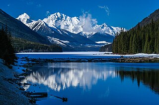
Mount Robson Provincial Park is a provincial park in the Canadian Rockies with an area of 2,249 km2. The park is located entirely within British Columbia, bordering Jasper National Park in Alberta. The B.C. legislature created the park in 1913, the same year as the first ascent of Mount Robson by a party led by Conrad Kain. It is the second oldest park in the provincial system. The park is named for Mount Robson, which has the highest point in the Canadian Rockies and is located entirely within the park.

Adams Lake Provincial Park is a provincial park in British Columbia, Canada. It encompasses three distinct parks: Adams Lake Provincial Park, Adams Lake Marine Provincial Park, and Adams Lake Marine Provincial Park.
Atlin/Áa Tlein Téix'i Provincial Park is a provincial park in British Columbia, Canada. Situated in the remote northwestern corner of the province, the park protects large tracts of boreal forest, alpine tundra and glaciated terrain. The southern third of Atlin Lake, the largest natural body of freshwater in the province, is within the park boundary. The park is very undeveloped; no roads traverse it and no facilities, supplies, developed campsites or maintained hiking trails are available inside the park. The area has become a focal point in controversies involving proposed hydroelectric projects affecting Atlin Lake and environmental groups who view these proposals as potentially damaging to the lake's environment and its surroundings.
Babine Lake Marine Park is on Babine Lake, which borders the Skeena and Omineca regions of central British Columbia. This provincial park comprises six separate sites around the lake. Vehicle access to the lake, via BC Highway 16 and Nilkitkwa forestry service road, is by road about 105 kilometres (65 mi) northeast of Smithers; via BC Highway 16 and Central Babine Lake Highway, is about 132 kilometres (82 mi) east of Smithers; or via Babine Lake Road, is about 20 kilometres (12 mi) northeast of Burns Lake.

Tā Chʼilā Provincial Park, formerly Boya Lake Provincial Park, is a provincial park located in the Stikine Region of British Columbia, Canada. The park located 120 km north-by-northwest of the community of Dease Lake near BC Highway 37. Boya Lake is named for Charlie Boya, a First Nations man from the area.

Birkenhead Lake Provincial Park is a provincial park in British Columbia, Canada, located in the Lillooet Country region. The park lies north of the communities of Squamish, Whistler and Pemberton, and immediately northwest of Birkenhead Peak and Gates Lake at the community of Birken.
Duffey Lake Provincial Park is a provincial park in British Columbia, Canada, located at the lake of the same name, which lies along BC Highway 99 just east of the summit of Cayoosh Pass. The lake's inflow and outflow are Cayoosh Creek. The park's highest point is Mount Rohr at the westernmost boundary.

Davis Lake Provincial Park is a 185 acres (0.75 km2) park in British Columbia, Canada, established as a protected provincial park in October 1963. It is located east of the southern end of Stave Lake, northeast of Mission, British Columbia, approximately 18 km north on Sylvester Rd from BC Highway 7. There are campgrounds and beaches at the south end of the lake, access is walk-in only via a 1 km unmaintained gravel road.
Elk Lakes Provincial Park is a provincial park in southeastern British Columbia, Canada, located west of the continental divide. It is located adjacent to Height of the Rockies Provincial Park and is about 104 kilometers north of Sparwood. The park features sub-alpine landscapes, remnant glaciers, rugged peaks and productive lakes. Much of the park is above treeline and features several prominent mountains including Mount Fox, Mount Aosta, Mount McCuaig, and Mount Elkan. The Petain, Castelnau, Nivelle, and Elk Glaciers lie on the northeastern edge of the park. The following lakes are also present inside park boundaries: Upper and Lower Elk Lake, Frozen Lake, Fox Lake, Cadorna Lake, and Abruzzi Lake. Below the treeline, the park features mature growth forests of alpine fir, Engelmann spruce, and lodgepole pine. These trees are also intermingled with juniper, twinberry, false azalea, white rhododendron, and buffalo berry. The wildlife of the area includes Beaver, Snowshoe Hare, Red Squirrel, white-tailed deer, moose, and many varieties of birds.
Emar Lakes Provincial Park is a provincial park in British Columbia, Canada. The park is located in the upper Emar Creek watershed, northwest of the community of Little Fort. The Hudson's Bay Company Brigade Trail was identified in the park near Jim Lake and Richard Lake.

Horne Lake Caves Provincial Park is a provincial park on Vancouver Island in British Columbia, Canada. Its principal function is the protection, management, and recreational use of several caves collectively known as the Horne Lake Caves.
Kootenay Lake Provincial Park is a provincial park in British Columbia, Canada. It encompasses five widely dispersed parks around Kootenay Lake: Kootenay Lake Provincial Park, Kootenay Lake Provincial Park, Kootenay Lake Provincial Park, Kootenay Lake Provincial Park, and Kootenay Lake Provincial Park.
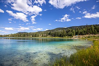
Kentucky Alleyne Provincial Park is a provincial park in British Columbia. The park is located 38 kilometres south of the city of Merritt, and east of the community of Aspen Grove. The park is named for two of its largest lakes, Kentucky Lake and Alleyne Lake. All lakes in the park have a distinctive turquoise colouration.
Kikomun Creek Provincial Park is a provincial park in British Columbia, Canada.

Mara Provincial Park is a day-use provincial park in British Columbia, Canada, located on Mara Lake south of Sicamous. The park is open with services from May 1 to September 27. The gate is locked open during the off season.

Muncho Lake Provincial Park is a provincial park in British Columbia, Canada, located on the Alaska Highway as it transits the northernmost Canadian Rockies west of Fort Nelson. The park is part of the larger Muskwa-Kechika Management Area. It is named after Muncho Lake, which is in the park and is both the name of the lake and of the community located there.
Woss Lake Provincial Park is a provincial park in British Columbia, Canada, located 75 kilometres southeast of Port McNeill, near the community of Woss, which is also known as Woss Lake.

Tantalus Provincial Park is a provincial park located in the Tantalus Range overlooking Squamish Valley in British Columbia, Canada. It was established on December 19, 1998 to protect a large area of pristine alpine wilderness.
Tsintsunko Lakes Provincial Park is a 333-hectare provincial park in British Columbia, Canada, located south of the Deadman River between Kamloops (SE) and Bonaparte Lake (NW). It is located on the Bonaparte Plateau. It was established April 30, 1996.
Tudyah Lake Provincial Park is a provincial park in British Columbia, Canada. The park is approximately 56 km south of Mackenzie, BC on Highway 97.

