
Adams Lake Provincial Park is a provincial park in British Columbia, Canada. It encompasses three distinct parks: Adams Lake Provincial Park, Adams Lake Marine Provincial Park, and Adams Lake Marine Provincial Park.

Bligh Island Marine Provincial Park is a provincial park in British Columbia, Canada.
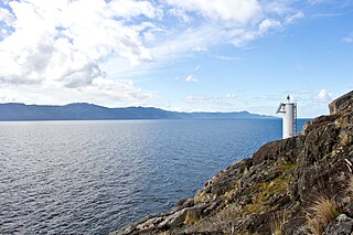
Catala Island Marine Provincial Park is a provincial park in British Columbia, Canaded on the west coast of Vancouver Island at the mouth of Esperanza Inlet, between Kyuquot Sound (N) and Nootka Sound (S). The park is 955 ha. in size and was established in July 1995.

Quatsino Provincial Park is a provincial park in British Columbia, Canada, located on Quatsino Sound on northern Vancouver Island. The park was established July 12, 1995 and is 654 hectares in size. The park is 50 kilometres (31 mi) west of Port Hardy, British Columbia and is accessible by rough logging roads or by boat. Quatsino is on a popular kayaking route.
Drewry Point Provincial Park is a provincial park in British Columbia, Canada, on the west side of Kootenay Lake, southeast of the city of Nelson.
Dixie Cove Marine Provincial Park, originally Dixie Cove Provincial Park, is a provincial park in British Columbia, Canada, located on the east side of Hohoae Island, which is just west of Fair Harbour in Kyuquot Sound on the West Coast of Vancouver Island.
Francis Point Provincial Park is a provincial park in British Columbia, Canada, located on the southwest end of the Francis Peninsula, south of the community of Pender Harbour on the west side of the Sechelt Peninsula in the Sunshine Coast region. Established in 2004, the park is 83 ha. in size, 74 ha. of it upland, the other 9 ha. foreshore.
Garden Bay Marine Provincial Park is a provincial park in British Columbia, Canada at the northwest end of the Sechelt Peninsula on the lower Sunshine Coast, near the community of Madeira Park. Established in 1969, it is approximately 163 ha.

God's Pocket Marine Provincial Park is a provincial park in southwest British Columbia, Canada, established on July 12, 1995. It is well known as a cold water scuba diving and kayaking destination. The park is 2,036 hectares in size, and includes two main islands, Hurst and Bell, as well as many smaller isles.

Harmony Islands Marine Provincial Park is a provincial park in British Columbia, Canada, located on the east side of Hotham Sound, which is a side-inlet of the lower reaches of Jervis Inlet, on that inlet's north side roughly opposite the mouth of Sechelt Inlet.
Lawn Point Provincial Park is a provincial park in British Columbia, Canada.

Pirates Cove Marine Provincial Park is a provincial park on De Courcy Island in British Columbia, Canada.

Plumper Cove Marine Provincial Park is a provincial park in British Columbia, Canada. The park is located on the northwest shore of Keats Island in Howe Sound, northwest of Vancouver, British Columbia.
Sabine Channel Provincial Park, also known as Sabine Channel Marine Provincial Park, is a provincial park in British Columbia, Canada, in the waters surrounding Jervis Island in Sabine Channel, which separates Texada Island, to the north, from Lasqueti Island, which lies to the south. Established in 2001, the park is approximately 2,254 hectares in size.

Simson Provincial Park is a provincial park in British Columbia, Canada.
St. Mary's Alpine Provincial Park is a provincial park in British Columbia, Canada. According to the Canadian Ministry of the Environment:
St. Mary’s Alpine Park is a wilderness paradise for the experienced backcountry traveller. Numerous lakes and tarns are tucked against rugged granite cliffs and surrounded by tundra and lingering snowfields. Seven creeks drain the lakes, resulting in numerous waterfalls and cataracts, some as much as 150 metres in height. Experienced hikers, willing to expend considerable effort in bushwhacking and route finding should visit this protected area where few, if any, people will be encountered.

Tetrahedron Provincial Park is a provincial park located within the territory of the shíshálh Nation on the southern Sunshine Coast, in British Columbia, Canada. The park was created in 1995 thanks to the efforts of a collective of NGOs who came together to protect the headwaters of the Chapman Creek and Gray Creek Community Watersheds from commercial logging activities.
Kyuquot Sound is a complex of coastal inlets, bays and islands on northwestern Vancouver Island in the Canadian province of British Columbia.
Buffalo Point First Nation is an Ojibwa or Saulteaux First Nations located in the southeastern corner of Manitoba, along the shores of Lake of the Woods. It is bordered largely by the unorganized portion of Division No. 1, Manitoba, and also has smaller borders with the Rural Municipality of Piney, as well as the northeast corner of Roseau County, Minnesota.

Lac La Ronge Provincial Park is located in the boreal forest of the north central part of the Canadian province of Saskatchewan within the Canadian Shield. Situated in the Churchill River system, this provincial park has close to 100 lakes and more than 30 canoe routes, many of which follow old fur trade routes. Summer activities include camping, hiking, boating, fishing, and swimming. In the winter, there's cross-country skiing, snowmobiling, and ice fishing. Saskatchewan's highest waterfall is in the park. Nistowiak Falls are located north of Lac La Ronge along the Rapid River.


