
Kokanee Glacier Provincial Park is one of the oldest provincial parks in British Columbia, established in 1922. The park has an area of 320.35 km2 (123.69 sq mi) and is located in the Selkirk Mountains in the West Kootenays region of BC. The park has three glaciers that feed over 30 alpine lakes which are the headwaters of many creeks.
Artlish Caves Provincial Park is a provincial park on Vancouver Island in British Columbia, Canada.

Bear Creek Provincial Park is a provincial park in British Columbia, Canada. It is situated on the west side of the Okanagan Lake and is northwest of the city of Kelowna. It was established on April 19, 1981, and was expanded to its current size of 178 hectares on May 12, 1988.
Beaver Creek Provincial Park is a Class C provincial park in the Regional District of Kootenay Boundary in British Columbia, Canada.

Browne Lake Provincial Park is a provincial park in British Columbia, Canada, located 22 km east-southeast of Kelowna in the Okanagan Highland, near Big White Ski Resort and between the heads of Hydraulic and Grouse Creeks.
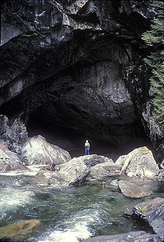
Cody Caves Provincial Park is a provincial park in British Columbia, Canada. It was formed in July 1966 to protect the Cody Caves and was the first subterranean park in British Columbia. The park is 13 km (8.1 mi) by road, northwest from the hot springs community of Ainsworth Hot Springs on Kootenay Lake.
Duffey Lake Provincial Park is a provincial park in British Columbia, Canada, located at the lake of the same name, which lies along BC Highway 99 just east of the summit of Cayoosh Pass. The lake's inflow and outflow are Cayoosh Creek. The park's highest point is Mount Rohr at the westernmost boundary.

Davis Lake Provincial Park is a 185 acres (0.75 km2) park in British Columbia, Canada, established as a protected provincial park in October 1963. It is located east of the southern end of Stave Lake, northeast of Mission, British Columbia, approximately 18 km north on Sylvester Rd from BC Highway 7. There are campgrounds and beaches at the south end of the lake, access is walk-in only via a 1 km unmaintained gravel road.
F.H. Barber Provincial Park is a provincial park in British Columbia, Canada. Comprising 8.5 ha of Fraser River floodplain in its natural state, it is one of only two secured public access points to the Fraser between Chilliwack and Hope. It is located at the confluence of Wahleach Creek and the Fraser one mile west of Laidlaw, British Columbia and is bounded on the south by the tracks of the Canadian National Railway.

Kakwa Provincial Park and Protected Area is a 170,890 ha provincial park in northeastern British Columbia, Canada. The park preserves the southernmost portion of the Hart Ranges and the northernmost portion of the Continental Ranges. The park also preserves significant marine fossil deposits located in the region.
Mehatl Creek Provincial Park is a provincial park in British Columbia, Canada, located in the central Lillooet Ranges to the west of Boston Bar.
Monkman Provincial Park is a provincial park in British Columbia, southwest of Tumbler Ridge and northeast of Hansard. Like Monkman Pass, Monkman Lake, Monkman Creek and Monkman Falls, it was named after Alexander Monkman.
Nitinat River Provincial Park is a provincial park in the Canadian province of British Columbia on Vancouver Island.
White Ridge Provincial Park is a provincial park in British Columbia, Canada, and is located 4 km east of Gold River on Vancouver Island.
Pine Le Moray Provincial Park is a provincial park in British Columbia, Canada. The park, 70 km southwest of Chetwynd covers 43,289 hectares. It is located within the Hart Ranges ecosection near the Rocky Mountains. It is within the Engelmann Spruce-Subalpine Fir biogeoclimatic zone. Water courses include Link and Mountain Creeks, the Pine River, and Heart Lake. It provides habitat for trout, Arctic grayling, mountain whitefish, high elevation caribou, moose, wolverine, and grizzly bear. It is recognized by the province as an area traditionally used by First Nations people. Its topography has examples of Karst topography and alpine areas.

Rosewall Creek Provincial Park is a provincial park in British Columbia, Canada, located northwest of the community of Bowser. The park is situated along picturesque Rosewall Creek, south of Fanny Bay on central Vancouver Island. The park features a mixture of coniferous trees interspersed with striking broad leaf maple trees. One of the best times to visit this park is in the fall when the color of the maple leaves makes an attractive backdrop for photographers.
Small River Caves Provincial Park is a provincial park in British Columbia, Canada.
Tranquil Creek Provincial Park is a provincial park in British Columbia, Canada, located at the head of the Kennedy River, east of the head of Bedwell Sound on Vancouver Island.
Close To The Edge Provincial Park and Protected Area is a provincial park and a protected area in British Columbia, Canada.

The Wells Gray Park Cave discovery of 2018 was of a karst cave in Wells Gray Provincial Park, in the Cariboo Mountains in British Columbia, Canada. The cave has informally been named Sarlacc's Pit pending an official name.


