Arrow Lakes Provincial Park is a provincial park in British Columbia, Canada.
Burns Lake Park is a provincial park in British Columbia, Canada, located near the town of Burns Lake. The park was established per Order in Council 63 on January 25, 2001, and constitutes approximately 65 hectares.

Blanket Creek Provincial Park is a provincial park in British Columbia, Canada. The park is 318 hectares in size. It hosts one of the nearest campgrounds for visitors going to the Mount Revelstoke National Park.
Call Lake Provincial Park is a provincial park in British Columbia, Canada, 5 kilometres (3.1 mi) southeast of Smithers, British Columbia, in the Bulkley Valley region. The park was established in 1999, comprising approximately 60 hectares.

Canim Beach Provincial Park is a provincial park in British Columbia, Canada, located at the southwest end of Canim Lake in the Interlakes District of the South Cariboo region, adjacent to the Secwepemc Indian reserve community of Canim Lake, British Columbia just northeast of 100 Mile House. The park was established by Order-in-Council in 1956 and expanded by later legislation in 2000 and 2004 to total a current approximate of 8.2 hectares, 3.6 hectares of upland and 4.6 hectares of foreshore.

Copeland Islands Marine Provincial Park is a provincial park in British Columbia, Canada, located in Desolation Sound to the northwest of Lund on the northern Sunshine Coast off the west coast of the Malaspina Peninsula.
Columbia Lake Provincial Park is a provincial park in British Columbia, Canada, located on the northeast shore of Columbia Lake south of the town of Invermere. The park was established in 1988, comprising approximately 260 hectares. Its boundary was expanded in 2004, the total now comprising approximately 290 hectares, 275 hectares of which is upland, 15 hectares of which is foreshore.

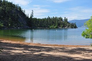
Champion Lakes Provincial Park is a provincial park in the West Kootenay region of British Columbia, Canada, northeast of the city of Trail in the province's West Kootenay region.
Claud Elliott Provincial Park is a provincial park in British Columbia, Canada located on northern Vancouver Island approximately 50 kilometres (31 mi) southeast of Port McNeill, between the Tsitsika River and Bonanza Lake, near the community of Woss.
Echo Lake Provincial Park is a provincial park in British Columbia, Canada, located south-east of Lumby in the Okanagan Highlands, to the south of BC Highway 6.
Ellison Provincial Park is a provincial park in British Columbia, Canada, located on the east side of Okanagan Lake to the south of the city of Vernon. The park contains approximately 219 hectares (2.19 km2) of land, 200 ha. of it upland, 19 ha. of it foreshore.
Kekuli Bay Provincial Park, formerly Kalamalka West Provincial Park, is a provincial park in British Columbia, Canada, located on the west shore of Kalamalka Lake on BC Highway 97 south of Vernon. The lake is popular for waterskiing and boating, and the park includes a boat launch, as well as a campground with a view of the lake. The park was established in 1990. Its size is about 57 hectares.
Kingfisher Creek Provincial Park is a provincial park in British Columbia, Canada located 15 km southeast of Sicamous and west of Mabel Lake in the Monashee Mountains. The park is 440 hectares and was created to enhance the viability of the Kingfisher Creek Ecological Preserve.

Monashee Provincial Park is a provincial park located just outside of Cherryville, British Columbia, Canada. It is located in the central Monashee Mountains between the Arrow Lakes and the upper Shuswap River drainage, just east of Sugar Lake. It is a remote grizzly habitat that is a walk-in only. Mount Fosthall is the highest peak in the area and can be hiked in a day. In addition to hiking and alpinism other activities include fishing.
Monte Lake Provincial Park is a provincial park in British Columbia, Canada, located on the east side of Monte Lake and to the south of the community of Monte Lake, British Columbia which is at the north end of the lake. About five hectares in size, it protects an area of Ponderosa pine and grasslands.

Niskonlith Lake Provincial Park is a provincial park in British Columbia, Canada, located southwest of the town of Chase. The park makes up an area of 275 hectares.
Skookumchuck Rapids Provincial Park is a provincial park in British Columbia, Canada, located on the Shuswap River just below the outlet of Mabel Lake. This park was established as a result of the Okanagan-Shuswap Land and Resource Management Plan.
Tyhee Lake Provincial Park is a provincial park in British Columbia, Canada, located near the town of Smithers in the Bulkley Valley.
Columbia Lake Ecological Reserve is a nature reserve on Columbia Lake in the East Kootenay region of British Columbia, Canada, located on the east side of Columbia Lake just north of the village of Canal Flats.
The Claud Elliott Creek Ecological Reserve is located southwest of the junction of Claud Elliott Creek and the Tsitsika River on northern Vancouver Island, southwest of the community of Sayward. The reserve, which was created to protect representative old-growth montane forests, was established in 1989, comprising approximately 231 hectares. It was expanded slightly in 2004 to a current total area of approximately 233 hectares.

