
Pacific Rim National Park Reserve is a 511 km2 (197 sq mi) national park located in British Columbia, Canada, which comprises three separate regions: Long Beach, the Broken Group Islands, and the West Coast Trail. It is located in the Pacific Coast Mountains, which are characterized by rugged coasts and temperate rainforests.

Gulf Islands National Park Reserve is a national park located on and around the Gulf Islands in British Columbia, Canada. In the National Parks System Plan, this park provides representation of the Strait of Georgia Lowlands natural region, the only place in Canada with a Mediterranean climate of dry, sunny summers and mild, wet winters, the result of a rain shadow effect from surrounding mountains between the region and the ocean. It has similar dominant vegetation as the Pacific Northwest, such as coastal Douglas-fir, western red cedar, shore pine, Pacific dogwood, bigleaf maple, and red alder, but also contains the northern extent of some of the more drought tolerant trees such as Garry oak and Arbutus. The park was created in 2003 as the fortieth national park. It covers 36 square kilometres (14 sq mi) of area on 16 islands and more than 30 islets, reefs and surrounding waters, making it the sixth smallest national park in Canada.

Bowron Lake Provincial Park is a wilderness provincial park located in east-central British Columbia, Canada, near the border with Alberta. It is 117 km (73 mi) east of the city of Quesnel. Other nearby towns include Wells and the historic destination of Barkerville. Once a popular hunting and fishing destination, today the park is protected and known for its abundant wildlife, rugged glaciated mountains, and freshwater lakes.
Crimson Lake Provincial Park is a provincial park located in Alberta, Canada, 14 kilometres (8.7 mi) west of Rocky Mountain House, off the David Thompson Highway along secondary highway 756.
Atlin/Áa Tlein Téix'i Provincial Park is a provincial park in British Columbia, Canada. Situated in the remote northwestern corner of the province, the park protects large tracts of boreal forest, alpine tundra and glaciated terrain. The southern third of Atlin Lake, the largest natural body of freshwater in the province, is within the park boundary. The park is very undeveloped; no roads traverse it and no facilities, supplies, developed campsites or maintained hiking trails are available inside the park. The area has become a focal point in controversies involving proposed hydroelectric projects affecting Atlin Lake and environmental groups who view these proposals as potentially damaging to the lake's environment and its surroundings.
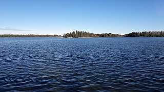
Babine Lake Marine Park is on Babine Lake, which borders the Skeena and Omineca regions of central British Columbia. This provincial park comprises six separate sites around the lake. Vehicle access to the lake, via BC Highway 16 and Nilkitkwa forestry service road, is by road about 105 kilometres (65 mi) northeast of Smithers; via BC Highway 16 and Central Babine Lake Highway, is about 132 kilometres (82 mi) east of Smithers; or via Babine Lake Road, is about 20 kilometres (12 mi) northeast of Burns Lake.

Golden Ears Provincial Park is a 555.9 square kilometres (214.6 sq mi) provincial park in British Columbia, Canada. It is named after the prominent twin peaks, which are commonly referred to as Golden Ears. The park was originally part of Garibaldi Provincial Park but was split off as a separate park in 1967. The area was logged extensively in the 1920s by the Lougheed and Abernathy Logging Company. Many recreational attractions are found within the park. Golden Ears Provincial Park is a protected area that contains many endangered species of flora and fauna.

Juniper Beach Provincial Park is a provincial park in the Thompson Country region of south central British Columbia, Canada. The facility is on the north side of the Thompson River, west of the town of Savona, and downstream from the Kamloops Lake outflow. On BC Highway 1, the locality is by road about 20 kilometres (12 mi) east of Cache Creek and 65 kilometres (40 mi) west of Kamloops.

Juan de Fuca Provincial Park is a provincial park located on the west coast of Vancouver Island in British Columbia, Canada. The park was established on April 4, 1996 by combining three former parks — China Beach, Loss Creek, and Botanical Beach — into one provincial park. It is the location of the majority of the Juan de Fuca Marine Trail, which is a southern compliment to the West Coast Trail within Pacific Rim National Park Reserve.

Say Nuth Khaw Yum Provincial Park, also known as Indian Arm Provincial Park, is a provincial park located in the Lower Mainland of British Columbia, Canada. The park was established on July 13, 1995 by BC Parks to protect the forested mountain terrain of Indian Arm.
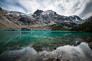
Joffre Lakes Provincial Park is a class A provincial park located 35 kilometres (22 mi) east of Pemberton in British Columbia, Canada. It was established in 1996, when Joffre Lakes Recreation Area was upgraded to park status.

Lockhart Beach Provincial Park is a provincial park Located 40 km north of Creston, British Columbia, Canada, on BC Highway 3A. "This park and the adjacent Lockhart Creek Provincial Park extend 3 hectares, from the sunny shores of Kootenay Lake to the headwaters of Lockhart Creek. "This small park provides the only easy access to public camping along the south arm of Kootenay Lake. An 18-site campground and day-use area are located near a sand and fine gravel beach."

Mitlenatch Island Nature Provincial Park is a provincial park in British Columbia, Canada encompassing Mitlenatch Island, a small islet in the northern Strait of Georgia within the Strathcona Regional District.
Norbury Lake Provincial Park is a 97-hectare (240-acre) provincial park in British Columbia, Canada.

Rolley Lake Provincial Park is a provincial park in British Columbia, Canada. It is located on Rolley Lake in the Stave Falls area of Mission, British Columbia. The area was inhabited by the Sto:lo people, homesteaded in 1888 by James and Fanny Rolley, and later used for logging operations. The park now provides campsites, use of the lake, and hiking, with an area of 115 hectares.

Kennedy Lake is the largest lake on Vancouver Island, British Columbia, Canada. Located north of Ucluelet on the island's central west coast, the lake is formed chiefly by the confluence of the Clayoquot and Kennedy Rivers. Outflow is via a short stretch of the Kennedy River into Tofino Inlet. The lake includes an extensive northern arm called Clayoquot Arm.

Strathcona Provincial Park is the oldest provincial park in British Columbia, Canada, and the largest on Vancouver Island. Founded in 1911, the park was named for Donald Alexander Smith, 1st Baron Strathcona and Mount Royal, a wealthy philanthropist and railway pioneer. It lies within the Strathcona Regional District. The Clayoquot Sound Biosphere Reserve, established in 2000, includes three watersheds in the western area of the park.
Tunkwa Provincial Park is a provincial park on the northern Thompson Plateau in south central British Columbia, Canada. The locality is by road about 16 kilometres (10 mi) north of Logan Lake and 27 kilometres (17 mi) south of Savona.
Caliper Lake Provincial Park is a small provincial park in northwestern Ontario, near the township of Nestor Falls. The park occupies 147 hectares alongside Caliper Lake. The facility is open for day use and overnight camping from mid-May to mid-September. The park features 83 campsites, many with electrical hookups, and some which may be rented for the entire season. The park offers many amenities, including a sandy beach, hiking trails, playground equipment, fish cleaning facilities, boat launches, bathrooms, and showers. Canoes, kayaks, and bicycles are available for rental.
Porcupine Hills Provincial Park is the newest provincial park in the Canadian Province of Saskatchewan. It was created in 2018 through the amalgamation of five pre-existing provincial recreation sites south-east of the town of Hudson Bay. The park is in the Porcupine Provincial Forest in the Porcupine Hills, which is a geographical feature in eastern Saskatchewan and western Manitoba. The hills are part of a range of hills called the Manitoba Escarpment.


