
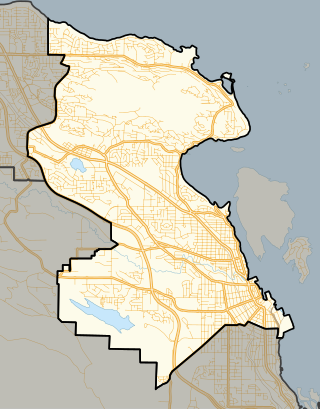
Nanaimo is a city of about 100,000 on the east coast of Vancouver Island, in British Columbia, Canada. "The Harbour City" was previously known as the "Hub City", which was attributed to its original layout design with streets radiating from the shoreline like the spokes of a wagon wheel, and to its relatively central location on Vancouver Island. Nanaimo is the headquarters of the Regional District of Nanaimo.

Saysutshun Provincial Park, formally known as Newcastle Island Marine Provincial Park, is a provincial park located on a small island off the coast of Nanaimo, British Columbia, Canada.

Gabriola Island is one of the Gulf Islands in the Strait of Georgia in British Columbia (BC), Canada. It is about 5 kilometres (3.1 mi) east of Nanaimo on Vancouver Island, to which it is linked by a 20-minute ferry service. It has a land area of about 57.6 square kilometres (22.2 sq mi) and a resident population of 4,500.

Duke Point is a geographical location in the extreme southeastern part of the city of Nanaimo in British Columbia. It is located on a thin peninsula to the east of the Nanaimo River estuary, just across the Northumberland Channel from Gabriola Island.
Nanaimo is a former provincial electoral district for the Legislative Assembly of British Columbia, Canada, in use until 2024.
Departure Bay is a bay in central Nanaimo, British Columbia, on the east coast of Vancouver Island. The surrounding neighbourhood is also referred to as "Departure Bay" —once a settlement of its own, it was amalgamated into the City of Nanaimo in the 1970s.

Buccaneer Bay Provincial Park is a provincial park in British Columbia, Canada, located 17 km west of Sechelt on North Thormanby Island, offshore from the community of Halfmoon Bay.
Hemer Provincial Park is a provincial park in British Columbia, Canada. It is located south of Nanaimo.

Pirates Cove Marine Provincial Park is a provincial park on De Courcy Island in British Columbia, Canada.

Plumper Cove Marine Provincial Park is a provincial park in British Columbia, Canada. The park is located on the northwest shore of Keats Island in Howe Sound, northwest of Vancouver, British Columbia.

Simson Provincial Park is a provincial park in British Columbia, Canada.

Cedar is a small community in the Canadian province of British Columbia. It is located near the east coast of Vancouver Island — about 8 kilometres (5.0 mi) south-east of Nanaimo — along the banks of the Nanaimo River. Its geographical coordinates are 49°07′N123°51′W.
The Artificial Reef Society of British Columbia (ARSBC) is a registered non-profit society based in Vancouver, British Columbia (BC), and has been a registered tax-deductible charity in Canada since 1992.
De Courcy Island is one of the Gulf Islands of the coast of southwestern British Columbia, Canada, located between the Pylades and Stuart Channels approximately 16 km (9.9 mi) southeast of Nanaimo and approximately 38 km (24 mi) west of Vancouver.

Mudge Island is one of the Southern Gulf Islands in the Strait of Georgia, in British Columbia (BC), Canada. It lies between Gabriola Island and Vancouver Island, and is considered part of the De Courcy group of islands. It is about 0.8 km (0.50 mi) wide and 4 km (2.5 mi) long. Dodd Narrows separates Mudge Island from Vancouver Island and False Narrows separates it from Gabriola Island. The northern tip of the island is the southern limit of the Port of Nanaimo and the southern most point of Northumberland Channel. Stuart Channel is south of Mudge Island.

Nanaimo-North Cowichan is a former provincial electoral district in British Columbia, Canada, in use from 2009 to 2024.

Horseshoe Bay is a major ferry terminal owned and operated by BC Ferries in British Columbia, Canada. Located in the community of Horseshoe Bay, a neighbourhood of West Vancouver, the terminal provides a vehicle ferry link from the Lower Mainland to Vancouver Island, the Sunshine Coast, and to Bowen Island, a small island in the southern part of Howe Sound.

Nanaimo River is a river on Vancouver Island, British Columbia, Canada, located near the city of Nanaimo on the island's east coast. Its headwaters are in the Vancouver Island Ranges of central Vancouver Island and its mouth, the Nanaimo River estuary, is at the south end of Nanaimo Harbour in the Strait of Georgia. The estuary is part of the Pacific Estuary Conservation Program.

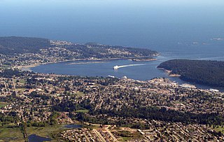
Nanaimo Harbour, also known as the Port of Nanaimo, is a natural harbour on the east coast of Vancouver Island in the Canadian province of British Columbia. The city of Nanaimo runs along the west side of the harbour. Three islands, Newcastle, Protection, and Gabriola, along with Duke Point, form the eastern edge. The Port of Nanaimo includes the Inner Harbour, Nanaimo River estuary, Departure Bay, the waters on the east side of Newcastle and Protection Islands, and Northumberland Channel. The port is under the management of the Nanaimo Port Authority.
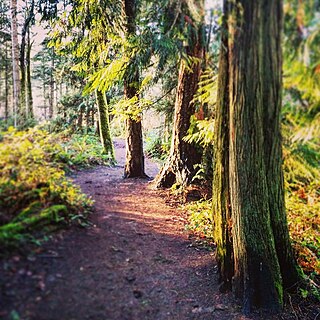
The Cable Bay Trail is a 2 km hiking trail located on Vancouver Island, British Columbia, Canada. The trail has been ranked among the top ten forest walks in the Vancouver Island Region.


