
Okanagan Mountain Provincial Park is a provincial park within the Okanagan-Similkameen Regional District of British Columbia, Canada, focused on the mountain of the same name and located on the east side of Okanagan Lake, opposite Peachland and immediately south of the City of Kelowna. The park is one of the largest in the area, covering 110.38 square kilometres (42.62 sq mi). Most of the park is only accessible by foot, horseback, bicycle, or boat as motor vehicle access is restricted to BC Parks staff and technicians servicing the three telecommunications towers in the park.
Anderson Bay Provincial Park is a provincial park in British Columbia, Canada, located on the southeast end of Texada Island near the community of Gillies Bay. Created in 2000, it is approximately 35 hectares in area.
Big Creek Provincial Park is a provincial park in British Columbia, Canada.

Cathedral Provincial Park and Protected Area, usually known as Cathedral Provincial Park and also as Cathedral Park, is a provincial park in British Columbia, Canada. It is located east of E.C. Manning Provincial Park, south of BC Highway 3, and southeast of the town of Princeton, and southwest of Keremeos. Its southern boundary is the border with the United States. Much of the park is the basin of the Ashnola River. Cathedral Park is home to teal sub-alpine lakes, vast ridges and jarred peaks, old-growth forests, and rock formations of siltstone, granodiorite, and basalt. Hikers can scramble along various peaks such as the 8000-foot Grimface Mountain and Lakeview Mountain. Tourists flock to Smokey the Bear and Stone City because of their unique formations with incredible views formed by millennia of erosion, volcanic and tectonic activity, and glacial recession.

Canim Beach Provincial Park is a provincial park in British Columbia, Canada, located at the southwest end of Canim Lake in the Interlakes District of the South Cariboo region, adjacent to the Secwepemc Indian reserve community of Canim Lake, British Columbia just northeast of 100 Mile House. The park was established by Order-in-Council in 1956 and expanded by later legislation in 2000 and 2004 to total a current approximate of 8.2 hectares, 3.6 hectares of upland and 4.6 hectares of foreshore.
Columbia Lake Provincial Park is a provincial park in British Columbia, Canada, located on the northeast shore of Columbia Lake south of the town of Invermere. The park was established in 1988, comprising approximately 260 hectares. Its boundary was expanded in 2004, the total now comprising approximately 290 hectares, 275 hectares of which is upland, 15 hectares of which is foreshore.
Ferry Island Provincial Park is a Class C provincial park in British Columbia that is located on the south side of the Fraser River northeast of Rosedale. This park is northwest of Bridal Falls, British Columbia and adjacent to the Agassiz-Rosedale Bridge. The Ferry Island Park was established in 1963, and it has an area of about 29 hectares.
Kootenay Lake Provincial Park is a provincial park in British Columbia, Canada. It encompasses five widely dispersed parks around Kootenay Lake: Kootenay Lake Provincial Park, Kootenay Lake Provincial Park, Kootenay Lake Provincial Park, Kootenay Lake Provincial Park, and Kootenay Lake Provincial Park.

Lowe Inlet Marine Provincial Park is a provincial park in British Columbia, Canada located on the Inside Passage of the North Coast, 118 km south of Prince Rupert and 75 km north of Butedale. Established on 14 June 1994, the park now contains approximately 765 hectares.

MacMillan Provincial Park is a 301-hectare (740-acre) provincial park in British Columbia, Canada. Located 25 km (16 mi) west of Qualicum Beach and 16 km (9.9 mi) east of Port Alberni, the park straddles Highway 4 and the Island Rail Corridor in central Vancouver Island. It is nestled on the western shore of Cameron Lake, and protects the delta of the Cameron River. The park is home to a famous, 157-hectare (390-acre) stand of ancient Douglas fir, known as Cathedral Grove, which draws visitors from all over the world. The park provides the only highway-accessible protected old-growth Douglas-fir forest in British Columbia. In 2007 Cathedral Grove made the short list on CBC's competition Seven Wonders of Canada.

Marble Canyon Provincial Park is a provincial park in British Columbia, Canada, established in 1956 to protect Marble Canyon, a limestone formation at the south end of the Marble Range. In 2001 the park was expanded to 355 hectares to include all of Pavilion Lake due to the presence of microbialites, a type of stromatolite important to research into astrobiology and other fields, and in 2010, it was further expanded to 2,544 hectares.
Monte Lake Provincial Park is a provincial park in British Columbia, Canada, located on the east side of Monte Lake and to the south of the community of Monte Lake, British Columbia which is at the north end of the lake. About five hectares in size, it protects an area of Ponderosa pine and grasslands.

Penrose Island Marine Provincial Park is a provincial park in the Central Coast region of British Columbia, Canada, located on the north side of the entrance to Rivers Inlet, 86 km north of Port Hardy at the south end of Fitz Hugh Sound. Comprising 1,079 hectares of marine area and 934 hectares of land area, the park is accessible by boat only and entrance to its anchorages are on its eastern side, the western being exposed to the open ocean. Exploration by dinghy and kayak are popular with visitors, as are nature viewing, scuba diving and exploring the islands many beaches and adjoining islets. The nearest supply centre for fuel and food is at the community of Rivers Inlet.
Prophet River Wayside Provincial Park is a provincial park in British Columbia, Canada. It is located along the Prophet River, by the Alaska Highway, between the localities of Trutch and Prophet River. Originally created as a Provincial Recreation Area in 1977 with an area of 707 acres (2.86 km2), it was designated a provincial park in 1999 with an area of 111 hectares.
Sabine Channel Provincial Park, also known as Sabine Channel Marine Provincial Park, is a provincial park in British Columbia, Canada, in the waters surrounding Jervis Island in Sabine Channel, which separates Texada Island, to the north, from Lasqueti Island, which lies to the south. Established in 2001, the park is approximately 2,254 hectares in size.

Silver Lake Provincial Park is a provincial park in British Columbia, Canada, located in the Skagit River Valley just south of Hope and comprising 77 hectares.

South Texada Island Provincial Park is a provincial park in British Columbia, Canada. It is located on the SouthWest side of Texada Island. Created in 1997, the park is approximately 900 hectares in area.
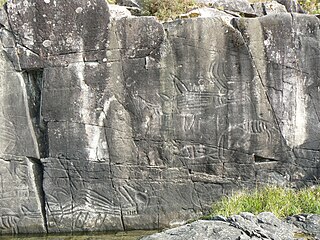
Sproat Lake Provincial Park is a provincial park near Port Alberni in British Columbia, Canada's Vancouver Island. Its name derives from a lake named after 19th century entrepreneur and colonial official Gilbert Malcolm Sproat.

BC Parks is an agency of the British Columbia Ministry of Environment and Climate Change Strategy that manages all of the, as of 2020, 1,035 provincial parks and other conservation and historical properties of various title designations within the province's Parks oversaw of the British Columbia Parks and Protected Areas System. The Lieutenant Governor-in-Council created the agency on March 1, 1911, through the Strathcona Park Act. The agency is charged with a dual role of preserving the ecological and historical integrity of the places entrusted to its management, while also making them available and accessible for public use and enjoyment.

Nahta Cone is a small cinder cone in Cassiar Land District of northwestern British Columbia, Canada. It has an elevation of 1,670 metres and lies near the northern edge of the Arctic Lake Plateau, a glacially scored plateau of the Tahltan Highland which in turn extends along the western side of the Stikine Plateau. The cone is about 70 kilometres south-southeast of the community of Telegraph Creek and lies in the southwestern corner of Mount Edziza Provincial Park, one of the largest provincial parks in British Columbia.

