
Lytton is a village of about 250 residents in southern British Columbia, Canada, on the east side of the Fraser River and primarily the south side of the Thompson River, where it flows southwesterly into the Fraser. The community includes the Village of Lytton and the surrounding community of the Lytton First Nation, whose name for the place is Camchin, also spelled Kumsheen.

Stein Valley Nlaka'pamux Heritage Park is a provincial park in British Columbia, Canada. It was established on November 22, 1995, by BC Parks and the Lytton First Nation to protect the ecological and cultural significance of the Stein River valley.

The Lillooet Ranges are the southeasternmost subdivision of the Pacific Ranges of the Coast Mountains of British Columbia. They are located between the drainage of the Lillooet River and Harrison Lake on the west and the canyon of the Fraser River on the east, and by the lowland coastal valley of that river on the south.

The Pacific Ranges are the southernmost subdivision of the Coast Mountains portion of the Pacific Cordillera. Located entirely within British Columbia, Canada, they run northwest from the lower stretches of the Fraser River to Bella Coola and Burke Channel, north of which are the Kitimat Ranges. The Coast Mountains lie between the Interior Plateau and the Coast of British Columbia.

The North Shore Mountains are a mountain range overlooking Vancouver in British Columbia, Canada. Their southernmost peaks are visible from most areas in Vancouver and form a distinctive backdrop for the city.

The Cantilever Range is a mountain range in southwestern British Columbia, Canada, a subrange of the Lillooet Ranges, which is itself a subgrouping of the Pacific Ranges of the Coast Mountains. About 1100 km2 in area and about 50 km east to west and 35 km north to south, the Cantilever Range is located southwest of Lytton between the valleys of the Stein River (N) and Kwoiek Creek (S).

The Purcell Wilderness Conservancy is a provincial park in British Columbia, Canada. It was established in 1974, and encompasses six large drainages in the Purcell Mountains in the southeast of the province. It contains high peaks, alpine meadows and ridges, deep creek and river valleys, and hot springs at Dewar Creek.

Mount Price is a small stratovolcano in the Garibaldi Ranges of the Pacific Ranges in southwestern British Columbia, Canada. It has an elevation of 2,049 metres and rises above the surrounding landscape on the western side of Garibaldi Lake in New Westminster Land District. The mountain contains a number of subfeatures, including Clinker Peak on its western flank, which was the source of two thick lava flows between 15,000 and 8,000 years ago that ponded against glacial ice. These lava flows are structurally unstable, having produced large landslides as recently as the 1850s. A large provincial park surrounds Mount Price and other volcanoes in its vicinity. It lies within an ecological region that surrounds much of the Pacific Ranges.

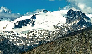
Skihist Mountain, also sometimes referred to as Skihist Peak, is the highest mountain in the Cantilever Range and in southwestern British Columbia, Canada. It is located on the southern boundary of Stein Valley Nlaka'pamux Heritage Park, about 20 km (12 mi) west of Lytton. It is the highest summit in the Lillooet Ranges, which lie between the Lillooet and Fraser Rivers, south of the Gates Valley and Seton and Anderson Lakes.

The Stein River is a tributary of the Fraser River in the Canadian province of British Columbia.

Botanie Mountain, also spelled Bootahnie Mountain, is a mountain in the Clear Range of the Southern Interior of British Columbia, Canada. It is located immediately north of the village of Lytton, which is situated at the confluence of the Thompson and Fraser Rivers.
The Cascade Mountains leeward forests are a temperate coniferous forest ecoregion of North America, as defined by the World Wildlife Fund (WWF) categorization system.
Petlushkwohap Mountain is a mountain in the Cantilever Range, located west of the town of Lytton, British Columbia, Canada, in that province's Fraser Canyon region. The Cantilever Range is a small subrange of the Lillooet Ranges, the southeasternmost subrange of the Pacific Ranges of the Coast Mountains. Petlushkwohap is the second-highest summit in the Lillooet Ranges, after nearby Skihist Mountain and is one of the mountains within the Stein Valley Nlaka'pamux Heritage Park.
Texas Creek is a medium-sized right tributary of the Fraser River in the Fraser Canyon region of that river's course, located approximately 16 miles down the river from the town of Lillooet. Texas Creek is also the name of the rural neighbourhood in the area of the creek, and also that of the Texas Creek Ranch which is one of the larger holdings.

Siwhe Mountain is a 2,843-metre (9,327-foot) summit located in British Columbia, Canada.
Kwoiek Peak is a 2,736-metre (8,976-foot) mountain summit located in British Columbia, Canada.

Antimony Mountain is a 2,668-metre (8,753-foot) mountain summit located in British Columbia, Canada.

Claimpost Peak is a 2,671-metre (8,763-foot) mountain summit located in British Columbia, Canada.
