
Chatuchak is one of the 50 districts (khet) of Bangkok, Thailand. The district is bounded by seven other districts : Lak Si, Bang Khen, Lat Phrao, Huai Khwang, Din Daeng, Phaya Thai, and Bang Sue.

The Kitimat Ranges are one of the three main subdivisions of the Coast Mountains in British Columbia, Canada, the others being the Pacific Ranges to the south and the Boundary Ranges to the north.

Desolation Sound is a deep water sound at the northern end of the Salish Sea and of the Sunshine Coast in British Columbia, Canada.
Burgoyne Bay Provincial Park is a provincial park in British Columbia, Canada located on southwestern Saltspring Island near Fulford Harbour. The parks faces northwest to Sansum Narrows, which is the channel between Saltspring Island and Vancouver Island. Mount Maxwell Provincial Park lies adjacent to the north.
Cormorant Channel Marine Provincial Park is a provincial park in British Columbia, Canada, located in the Pearse Islands, a small archipelago to the east of Cormorant Island and the Village of Alert Bay at the western end of Johnstone Strait.
Dawley Passage Provincial Park is a provincial park in British Columbia, Canada, located at the south end of Fortune Channel, which lies between Meares Island and the mainland of Vancouver Island just south. The park is to the north of the resort town of Tofino and is accessible by boat only. It was created on July 13, 1995 as part of the Clayoquot Land-Use Decision and contains 154 ha, .

Foch-Gilttoyees Provincial Park is a provincial park in British Columbia, Canada. The park and protected area encompasses 61,089 hectares of coastal terrain from sea level up to alpine. The park contains part of the historical First Nations travel path between the Skeena River and the Douglas Channel. The remainder of the route is located in Gitnadoiks River Provincial Park. Together, the two parks provide a continuous protected corridor between the river and the channel.

Helliwell Provincial Park is a provincial park in British Columbia, Canada located on a headland at the northeast end of Hornby Island.
Jackson Narrows Marine Provincial Park is a provincial park in British Columbia, Canada, located on the west side of Mathieson Channel to the north of the community of Bella Bella.
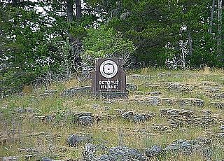
Octopus Islands Marine Provincial Park is a provincial park in British Columbia, Canada. It is located between Quadra Island and Maurelle Island in Okisollo Channel.

Klewnuggit Inlet Marine Provincial Park is a provincial park in British Columbia, Canada, located on the east side of Grenville Channel, 100 kilometres (62 mi) southeast of Prince Rupert, in the Range 4 Coast Land District.
Union Passage Marine Provincial Park is a provincial park within the asserted traditional territory of the Tsimshian First Nations. The marine protected area is located at the southwest end of Grenville Channel straddling Pitt and Farrant Islands, in British Columbia, Canada.
Walsh Cove Provincial Park is a provincial park in located on the northeast corner of West Redonda Island in British Columbia, Canada. The park is approximately 85 ha. in size and overlooks Waddington Channel.
Rendezvous Island South Provincial Park is a provincial park in British Columbia, Canada, located in the Rendezvous Islands in Calm Channel, to the east of the north end of Read Island in the Discovery Islands at the northern end of the Strait of Georgia region. The park contains a total of 164 ha. 113 ha. of it upland, 53 ha. of it foreshore.
Roscoe Bay Provincial Park is a provincial park in British Columbia, Canada, comprising the southeast portion of West Redonda Island, facing Desolation Sound and Waddington Channel.
Sabine Channel Provincial Park, also known as Sabine Channel Marine Provincial Park, is a provincial park in British Columbia, Canada, in the waters surrounding Jervis Island in Sabine Channel, which separates Texada Island, to the north, from Lasqueti Island, which lies to the south. Established in 2001, the park is approximately 2,254 hectares in size.

Sir Alexander Mackenzie Provincial Park is a provincial park in British Columbia, Canada. Located at the mouth of Elcho Harbour on Dean Channel, it enshrines the farthest point west reached by Alexander Mackenzie in 1793 and the rock he marked to commemorate his journey. The park is also the location of a historical First Nations village, with petroglyphs that can be found along the beach.

Pinery Provincial Park is a provincial park located on Lake Huron near Grand Bend, Ontario. It occupies an area of 25.32 square kilometres. It is a natural environment-class Provincial Park created to help preserve oak savannah and the beach dune ecology. It has 1,275 sites of which 404 have electrical hookups. These include the yurt camping area and the group camping sites.
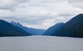
Grenville Channel is a strait on the North Coast of British Columbia, Canada, between Pitt Island and the mainland to the south of Prince Rupert. It is part of the Inside Passage shipping route, about 45 nautical miles long and is 0.2 nautical miles wide at its narrowest point.
Shop LC, formerly known as Liquidation Channel and The Jewelry Channel, is an American cable television network based in Austin, Texas, which mainly specializes in selling jewelry. The network is a subsidiary of the Indian-based Vaibhav Global Limited.

