
Mount Robson Provincial Park is a provincial park in the Canadian Rockies with an area of 2,249 km2. The park is located entirely within British Columbia, bordering Jasper National Park in Alberta. The B.C. legislature created the park in 1913, the same year as the first ascent of Mount Robson by a party led by Conrad Kain. It is the second oldest park in the provincial system. The park is named for Mount Robson, which has the highest point in the Canadian Rockies and is located entirely within the park.

Kokanee Glacier Provincial Park is one of the oldest provincial parks in British Columbia, established in 1922. The park has an area of 320.35 km2 (123.69 sq mi) and is located in the Selkirk Mountains in the West Kootenays region of BC. The park has three glaciers that feed over 30 alpine lakes which are the headwaters of many creeks.
Cummins Lakes Provincial Park and Protected Area is a provincial park and protected area located in the eastern interior of British Columbia, Canada. It was established on August 4, 2000 to protect mountainous wilderness along the Cummins River.

Sx̱ótsaqel/Chilliwack Lake Provincial Park is a provincial park in British Columbia, Canada. Covering 92.58 km2, the park is located 150 km east of Vancouver in the Chilliwack River Valley.
Choquette Hot Springs Provincial Park is a provincial park located in the Stikine Country region of British Columbia, Canada. It was established on January 25, 2001, to protect Stikine River Hot Springs, the largest hot springs on the Canadian side of the lower Stikine River.
Dune Za Keyih Provincial Park and Protected Area, also known as the Frog-Gataga Provincial Park, is a provincial park in British Columbia, Canada. It is part of the larger Muskwa-Kechika Management Area and is located in the area of the Gataga River, between Denetiah Provincial Park, which lies west across the Kechika River, and Kwadacha Wilderness Provincial Park to its east. Established in 2001 as Frog-Gataga, the park is 346,833 hectares in area; its newer name is a Kaska Dena translation of Frog-Gataga.
Denetiah Provincial Park and Protected Area is a provincial park and protected area located in the northern interior of British Columbia, Canada. It was established on June 29, 1999 to protect a large area of pristine wilderness at the headwaters of the Denetiah and Dahl Rivers.
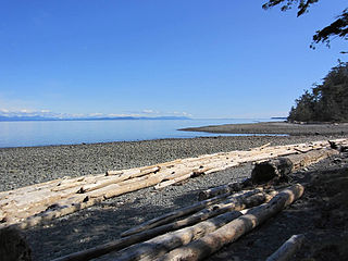
Gordon Bay Provincial Park is a provincial park in British Columbia, Canada.

Hamber Provincial Park is a provincial park in British Columbia, Canada, located 130 kilometres (80.7 mi) north of Golden. Straddling the Great Divide on the provincial boundary with Alberta, the park is surrounded on three sides by Jasper National Park and protects the headwaters of the Wood River at Fortress Lake.

Juan de Fuca Provincial Park is a provincial park located on the west coast of Vancouver Island in British Columbia, Canada. The park was established on April 4, 1996 by combining three former parks — China Beach, Loss Creek, and Botanical Beach — into one provincial park. It is the location of the majority of the Juan de Fuca Marine Trail, which is a southern compliment to the West Coast Trail within Pacific Rim National Park Reserve.
Kikomun Creek Provincial Park is a provincial park in British Columbia, Canada.
Kitty Coleman Provincial Park, also known as Kitty Coleman Beach Provincial Park, is a Class C provincial park located in British Columbia, Canada. It is located on Vancouver Island, in the Comox Valley, south of the mouth of the Oyster River just northeast of Courtenay.

MacMillan Provincial Park is a 301-hectare (740-acre) provincial park in British Columbia, Canada. Located 25 km (16 mi) west of Qualicum Beach and 16 km (9.9 mi) east of Port Alberni, the park straddles Highway 4 and the Island Rail Corridor in central Vancouver Island. It is nestled on the western shore of Cameron Lake, and protects the delta of the Cameron River. The park is home to a famous, 157-hectare (390-acre) stand of ancient Douglas fir, known as Cathedral Grove, which draws visitors from all over the world. The park provides the only highway-accessible protected old-growth Douglas-fir forest in British Columbia. In 2007 Cathedral Grove made the short list on CBC's competition Seven Wonders of Canada.

Muncho Lake Provincial Park is a provincial park in British Columbia, Canada, located on the Alaska Highway as it transits the northernmost Canadian Rockies west of Fort Nelson. The park is part of the larger Muskwa-Kechika Management Area. It is named after Muncho Lake, which is in the park and is both the name of the lake and of the community located there.
Schoen Lake Provincial Park is a provincial park in northeastern Vancouver Island, British Columbia, Canada, located east of the community of Woss Lake and southwest of Sayward. The park lies inside the Nimpkish Valley watershed. On October 28, 1977, the "Class A" park was officially created to protect, exhibit and interpret an example of the natural features and processes of the Insular Mountains Natural Region. The park covers a total area of 8,775 hectares. Within those hectares of park land is a number of lakes, creeks and mountain ranges.

Tantalus Provincial Park is a provincial park located in the Tantalus Range overlooking Squamish Valley in British Columbia, Canada. It was established on December 19, 1998 to protect a large area of pristine alpine wilderness.

Pembina Valley Provincial Park is a provincial park in southern Manitoba, Canada. It is located 47 kilometres south-west of Morden, Manitoba, Canada on Highway 3, Highway 31, and Highway 201, and covers approximately 1.8 square kilometres. The park is considered to be a Class III protected area under the IUCN protected area management categories.
Close To The Edge Provincial Park and Protected Area is a provincial park and a protected area in British Columbia, Canada.
Omineca Provincial Park and Protected Area is a provincial park and protected area located in the north-central interior of British Columbia, Canada. It was established on 11 April 2001 by BC Parks to protect provincially significant riparian and wetland habitats along the Omineca River.

White Lake Grasslands Protected Area is a conservation site located in the Regional District of Okanagan-Similkameen of British Columbia, Canada. It was established on April 18, 2001 by an order-in-council under the Environment and Land Use Act to protect the semi-arid grassland and pine forest ecosystem west of Vaseux Lake.

