Related Research Articles

Sidney is a town located at the northern end of the Saanich Peninsula, on Vancouver Island in the Canadian province of British Columbia. It's 1 of the 13 Greater Victoria municipalities. It has a population of approximately 11,583. Sidney is located just east of Victoria International Airport, and about 6 km (4 mi) south of BC Ferries' Swartz Bay Terminal. The town is also the only Canadian port-of-call in the Washington State Ferries system, with ferries running from Sidney to the San Juan Islands and Anacortes. Sidney is located along Highway 17, which bisects the town from north to south. It is generally considered part of the Victoria metropolitan area.

Lasqueti Island is an island off the east coast of Vancouver Island in the Strait of Georgia, qathet Regional District, British Columbia, Canada and has a population of 498. A passenger-only ferry connects the island to the community of French Creek, near Parksville. The ferry makes two to three runs per day, six days per week, weather permitting. The ferry service is run by Western Pacific Marine for BC Ferries.

Port Hardy is a district municipality in British Columbia, Canada located on the north-east end of Vancouver Island. Port Hardy has a population of 4,132 as of the last census (2016).

Vargas Island Provincial Park is a provincial park in British Columbia, Canada, comprising the west side of the island of the same name, which is located west of Meares Island and northwest of the resort community of Tofino in the Clayoquot Sound region of the West Coast of Vancouver Island, British Columbia, Canada. The park was created as part of the Clayoquot Land-Use Decision on July 13, 1995 and contains 5,805 hectares, 1,543 hectares of it being upland and 4,262 hectares being foreshore. Also located on Vargas Island, on its north side, is Epper Passage Provincial Park.
Lower Tsitika River Provincial Park is a provincial park in British Columbia, Canada.
Memory Island Provincial Park is a provincial park located on Vancouver Island in British Columbia, Canada. It was established by BC Parks on 23 August 1945 to protect a small island located at the southern end of Shawnigan Lake.

The Golden Hinde is a mountain located in the Vancouver Island Ranges on Vancouver Island, British Columbia, Canada. At 2,195 metres (7,201 ft), it is the highest peak on the island. The peak is popular with experienced backcountry-climbers, having been first ascended in 1913. The mountain is made of basalt which is part of the Karmutsen Formation.
BC Parks is an agency of the British Columbia Ministry of Environment and Climate Change Strategy that manages all of the, as of 2020, 1,035 provincial parks and other conservation and historical properties of various title designations within the province's Parks oversaw of the British Columbia Parks and Protected Areas System. The Lieutenant Governor-in-Council created the agency on March 1, 1911, through the Strathcona Park Act. The agency is charged with a dual role of preserving the ecological and historical integrity of the places entrusted to its management, while also making them available and accessible for public use and enjoyment.

Buttle Lake is a lake on Vancouver Island in Strathcona Regional District, British Columbia, Canada. It is about 23 kilometres (14 mi) long and 1.5 kilometres (0.9 mi) wide, has an area of 28 square kilometres (11 sq mi), is up to 120 metres (394 ft) deep, and lies at an elevation of 221 metres (725 ft). The lake is located between Campbell River and Gold River in Strathcona Provincial Park. The lake is the headwaters of the Campbell River.
Saturna Island is a mountainous island, about 31 square kilometres (12 sq mi) in size, in the Southern Gulf Islands chain of British Columbia, Canada. It is situated approximately midway between the Lower Mainland of B.C. and Vancouver Island, and is the most easterly of the Gulf Islands. It is surrounded on three sides by the Canada–United States border. To the north is Point Roberts, Washington, and to the east and south are the San Juan Islands. There is a First Nations reserve on the island for the Tsayout and Tseycum Nations. The island has a permanent population of around 350, however, this number increases during the summer season.
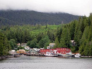
Telegraph Cove is a community of about 20 inhabitants, on Vancouver Island in British Columbia, Canada, located approximately 210 kilometres (130 mi) northwest of Campbell River. It is a former fishing and cannery village that has become a launch point for eco-tourism. It shares the inlet with Beaver Cove which is 3 km (2 mi) up the inlet.

Johnstone Strait is a 110 km (68 mi) channel along the north east coast of Vancouver Island in British Columbia, Canada. Opposite the Vancouver Island coast, running north to south, are Hanson Island, West Cracroft Island, the mainland British Columbia Coast, Hardwicke Island, West Thurlow Island and East Thurlow Island. At that point, the strait meets Discovery Passage which connects to Georgia Strait.

The North Coast Trail is a 43.1 km (26.8 mi) wilderness hiking trail in Cape Scott Provincial Park on northern Vancouver Island, British Columbia, Canada.

The Trial Islands are a group of islands located off the south-eastern tip of Vancouver Island off Victoria, part of the municipality of Oak Bay. The islands form the Trial Islands Ecological Reserve and entry outside designated zones is prohibited.
Mount Benson is a mountain located on Vancouver Island, British Columbia located 9 km (5.6 mi) west of Nanaimo. At one time, there was road access to the peak as there was a fire lookout at the summit. Today, the road is closed to vehicles but the mountain has become popular with local hikers as it has great views of the Strait of Georgia, the mainland Coast Mountains of British Columbia, the Nanaimo River valley, and the Vancouver Island Ranges, including Mount Arrowsmith.

Michael Andrew Bigg was an English-born Canadian marine biologist who is recognized as the founder of modern research on killer whales. With his colleagues, he developed new techniques for studying killer whales and conducted the first population census of the animals. Bigg's work in wildlife photo-identification enabled the longitudinal study of individual killer whales, their travel patterns, and their social relationships in the wild, and revolutionized the study of cetaceans.

Alexandra Bryant Hubbard Morton is best known for her 30-year study of wild killer whales in the Broughton Archipelago in British Columbia. Since the 1990s, her work has shifted toward the study of the impact of salmon farming on Canadian wild salmon.

Mount Tzouhalem is a mountain on Vancouver Island, British Columbia, Canada, 4 kilometres east-northeast of Duncan in the municipality of North Cowichan. It is situated between Quamichan Lake, Maple Bay and Cowichan Bay.
Scott Islands Marine National Wildlife Area is a National Wildlife Area off the northwestern tip of Vancouver Island in the Canadian province of British Columbia. Covering an area of 11,570.65 km2 (4,467.45 sq mi), it is the second largest protected area in British Columbia after Offshore Pacific Seamounts and Vents Closure and is the largest national wildlife area in Canada.
References
- ↑ The Canadian Press (October 19, 2007). "Environmentalists investigate Robson Bight wreckage". CBCNEWS.CA. Retrieved 2008-06-04.
- ↑ Ministry of Environment, BC Parks. "Robson Bight (Michael Bigg) Ecological Reserve" . Retrieved 2008-06-05.
- ↑ Walbran, Captain John T. (1971). British Columbia Place Names, Their Origin and History (Facsimile reprint of 1909 ed.). Vancouver/Toronto: Douglas & McIntyre. ISBN 0-88894-143-9. Archived from the original on 2016-03-03.
- ↑ Akrigg, G.P.V.; Akrigg, Helen B. (1986), British Columbia Place Names (3rd, 1997 ed.), Vancouver: UBC Press, ISBN 0-7748-0636-2
- ↑ "GOVERNMENTS PLAN TO SALVAGE ROBSON BIGHT WRECKAGE" (Press release). British Columbia Ministry of Environment. April 18, 2008. Retrieved 2008-06-04.
- ↑ CBC (May 20, 2009). "Sunken fuel truck recovered from Robson Bight". CBC.CA. Retrieved 2009-05-21.