
Adams Lake Provincial Park is a provincial park in British Columbia, Canada. It encompasses three distinct parks: Adams Lake Provincial Park, Adams Lake Marine Provincial Park, and Adams Lake Marine Provincial Park.
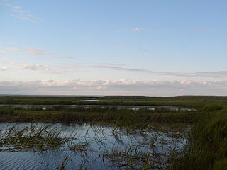
Banana Island Provincial Park is a provincial park in British Columbia, Canada. It is a small 10.4 hectare island in the South Thompson River, located approximately 35 kilometres east of Kamloops. There are no camping or recreational facilities, as it is an environmentally sensitive area. The island was designated as a provincial park on 30 April 1996 following recommendations from the Kamloops Land and Resource Management Plan to protect spring salmon spawning grounds and nesting grounds for several varieties of birds. It is used for nesting by Canada geese, Osprey and bald eagles, and other waterfowl and raptors. It is also a winter habitat for Tundra and Trumpeter swans. The island is vegetated with ponderosa pine and grassy undercover, and was historically used by the Neskonlith First Nation in accessing river resources.
Brackendale Eagles Provincial Park is a provincial park in British Columbia, Canada, located on the Squamish River adjacent to Brackendale, a suburban neighbourhood of Squamish. It is notable for its bald eagle population during the winter months and is inaccessible to visitors.

Cathedral Provincial Park and Protected Area, usually known as Cathedral Provincial Park and also as Cathedral Park, is a provincial park in British Columbia, Canada. It is located east of E.C. Manning Provincial Park, south of BC Highway 3, and southeast of the town of Princeton, and southwest of Keremeos. Its southern boundary is the border with the United States. Much of the park is the basin of the Ashnola River. Cathedral Park is home to teal sub-alpine lakes, vast ridges and jarred peaks, old-growth forests, and rock formations of siltstone, granodiorite, and basalt. Hikers can scramble along various peaks such as the 8000-foot Grimface Mountain and Lakeview Mountain. Tourists flock to Smokey the Bear and Stone City because of their unique formations with incredible views formed by millennia of erosion, volcanic and tectonic activity, and glacial recession.
Cottonwood River Provincial Park is a provincial park in British Columbia, Canada, located northeast of the confluence of the Fraser and Cottonwood Rivers in that province's North Cariboo region.

Davis Lake Provincial Park is a 185 acres (0.75 km2) park in British Columbia, Canada, established as a protected provincial park in October 1963. It is located east of the southern end of Stave Lake, northeast of Mission, British Columbia, approximately 18 km north on Sylvester Rd from BC Highway 7. There are campgrounds and beaches at the south end of the lake, access is walk-in only via a 1 km unmaintained gravel road.

E.C. Manning Provincial Park is a provincial park in British Columbia, Canada. It is usually referred to as Manning Park, although that nomenclature is also used to refer to the resort and ski area at the park's core. The park covers 83,671 hectares (323 mi2) and was the second most visited provincial park in 2017-18 after Cypress Provincial Park. The park lies along British Columbia Highway 3, and occupies a large amount of land between Hope and Princeton along the Canada-United States border.
Ed Bird – Estella Lakes Provincial Park is a provincial park in British Columbia, Canada.
Long Point Provincial Park is a provincial park on the northwest shore of Lake Erie near Port Rowan, Ontario, Canada. The park is part of a sandy spit of land called Long Point that juts out into the lake. It covers part of the area of Long Point Biosphere Reserve, which was designated a UNESCO Biosphere Reserve because of its biological significance.

Juniper Beach Provincial Park is a provincial park in the Thompson Country region of south central British Columbia, Canada. The facility is on the north side of the Thompson River, west of the town of Savona, and downstream from the Kamloops Lake outflow. On BC Highway 1, the locality is by road about 20 kilometres (12 mi) east of Cache Creek and 65 kilometres (40 mi) west of Kamloops.
Inkaneep Provincial Park is a provincial park near Oliver, British Columbia, Canada, located just south of the town of Okanagan Falls. The park contributes to the protection of critical riparian values on the Okanagan River. The park is popular with naturalists, particularly bird-watchers. First Nations have identified the river and riparian area of the park as very important contributor to the long-term viability of the Okanagan River salmon run.
King George VI Provincial Park is a provincial park in British Columbia, Canada. It was established by Order in Council on May 3, 1937, named in commemoration of the coronation of George VI. 162 acres (0.66 km2) in area, the park was originally established to provide a rest area and campground for travellers on BC Hwy 22 entering Canada from the United States, the site's facilities were repeatedly vandalized until they were finally removed by BC Parks and the site left to revert to its natural state. There are no facilities in this park, nor any trails. The park's stands of old-growth Populus trichocarpa shelter it from neighbouring mixed-use areas and serve as habitat for cavity nesting birds, such as barred owls, pileated woodpeckers and red-naped sapsuckers.
Lockhart Creek Provincial Park is a provincial park in British Columbia, Canada, located adjacent to Lockhart Beach Provincial Park, 40 km north of Creston, British Columbia on the east shore of Kootenay Lake.

Mara Provincial Park is a day-use provincial park in British Columbia, Canada, located on Mara Lake south of Sicamous. The park is open with services from May 1 to September 27. The gate is locked open during the off season.

Mitlenatch Island Nature Provincial Park is a provincial park in British Columbia, Canada encompassing Mitlenatch Island, a small islet in the northern Strait of Georgia within the Strathcona Regional District.
Morrissey Provincial Park is a provincial park near the southeastern corner of British Columbia, Canada. The park is primitive, with no designated picnic or day-use areas, and no available parking. The park protects a remnant Black Cottonwood ecosystem.

Myra-Bellevue Provincial Park is a provincial park in British Columbia, Canada, located in the Okanagan Highland east of Kelowna. It was established to protect the full elevational range of the North Okanagan Basin and North Okanagan Highlands ecosections.
Okanagan Lake Provincial Park is a provincial park in British Columbia, Canada. Established in 1955, the park covers a total area of 98 hectares.
Wire Cache Provincial Park is a provincial park in British Columbia, Canada, located 90 km northeast of Clearwater.

Kettle River Recreation Area is a 179 hectare provincial recreation area located inside a sharp S-bend of the Kettle River approximately 6 kilometres north of the community of Rock Creek, British Columbia. It is one of only two recreation areas in British Columbia, the other being Coquihalla Summit Recreation Area.

