
New Denver is a village in the Central Kootenay region of British Columbia, Canada at the mouth of Carpenter Creek, on the east shore of Slocan Lake, in the West Kootenay region of southeastern British Columbia. The village is 47 kilometres (29 mi) west of Kaslo on Highway 31A, and 47 kilometres (29 mi) southeast of Nakusp and 32 kilometres (20 mi) northeast of Slocan on Highway 6.

The Columbia Mountains are a group of mountain ranges along the Upper Columbia River in British Columbia, Montana, Idaho and Washington. The mountain range covers 135,952 km². The range is bounded by the Rocky Mountain Trench on the east, and the Kootenai River on the south; their western boundary is the edge of the Interior Plateau. Seventy-five percent of the range is located in Canada and the remaining twenty-five percent in the United States; American geographic classifications place the Columbia Mountains as part of the Rocky Mountains complex, but this designation does not apply in Canada. Mount Sir Sandford is the highest mountain in the range, reaching 3,519 metres (11,545 ft).

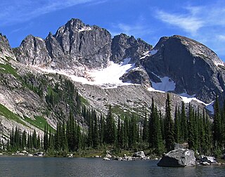
Kokanee Glacier Provincial Park is one of the oldest provincial parks in British Columbia, established in 1922. The park has an area of 320.35 km2 (123.69 sq mi) and is located in the Selkirk Mountains in the West Kootenays region of BC. The park has three glaciers that feed over 30 alpine lakes which are the headwaters of many creeks.
Goat Range Provincial Park is a provincial park in British Columbia, Canada.
Colleen McCrory was a Canadian environmental activist.
The Slocan Valley is a valley in the West Kootenay region of southeastern British Columbia.

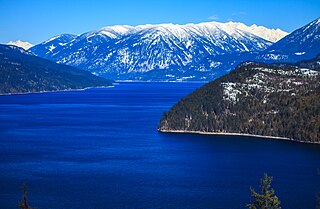
Slocan Lake is a lake in the Slocan Valley of the West Kootenay region of the Southeastern Interior of British Columbia, Canada. With an area of 69.29 km2 (26.75 sq mi) it has a maximum depth of 298 m (978 ft). It is fed by Bonanza Creek and drained by the Slocan River.

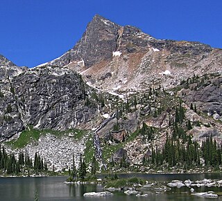
Gladsheim Peak is a prominent 2,830-metre (9,280-foot) mountain summit located in the Valhalla Ranges of the Selkirk Mountains in British Columbia, Canada. Gladsheim is the highest point in the Valhalla Ranges. It is situated in the southern part of Valhalla Provincial Park, 2.7 km (1.7 mi) northeast of Gimli Peak, and 12 km (7.5 mi) west of Slocan and Slocan Lake. The name "Valhalla Mountains" first appeared in George Mercer Dawson's Geological Survey of Canada map published in 1890. Dawson applied names derived from Scandinavian mythology to several of the mountain ranges and peaks in Southern Kootenay. Gladsheim is the magnificent meeting hall containing thirteen council seats where, according to Norse mythology, Odin presided over all the realms. In keeping with the Valhalla theme, this peak's name was submitted in 1900 by R. W. Brock to the Geological Survey of Canada for consideration, and it was officially adopted March 31, 1924, by the Geographical Names Board of Canada.

Gregorio Peak is a 2,605-metre (8,547-foot) mountain summit located in the Valhalla Ranges of the Selkirk Mountains in British Columbia, Canada. It is situated on the southwestern border of Valhalla Provincial Park, 8.7 km (5.4 mi) west of Gladsheim Peak, and 19 km (12 mi) west of Slocan and Slocan Lake. The mountain's name commemorates Michael Gregory, a resident of the Slocan area known to his friends as Gregorio, who drowned in a canoeing accident on Slocan Lake in 1971 returning from a climb of nearby Devils Couch. This peak's name was submitted by Anthony Eweson of New Denver for consideration, and it was officially adopted March 4, 1974, by the Geographical Names Board of Canada.

Devils Couch is a 2,749-metre (9,019-foot) mountain summit located in the Valhalla Ranges of the Selkirk Mountains in southeast British Columbia, Canada. It is situated in Valhalla Provincial Park, 5 km (3.1 mi) north of Gladsheim Peak, 12 km (7.5 mi) west of Slocan Lake, and 15 km (9.3 mi) northwest of Slocan. The mountain's descriptive name refers to its shape. It was first called "The Toboggan Slide" by early miners who arrived in the area in the 1890s. It was later called "King Tuts Couch" in the 1920s, coinciding with the archaeological discovery in Egypt. This peak's current name was officially adopted July 22, 1964, by the Geographical Names Board of Canada. The peak is located in Devils Range, which is a compact subrange of the Valhallas. The names of the neighboring peaks have a devil-related theme: Black Prince Mountain, Lucifer Peak, Mount Mephistopheles, Devils Dome, Mount Diablo, Satan Peak, and Devils Spire.

Mount Denver is a 2,746-metre (9,009-foot) mountain summit located in the Valhalla Ranges of the Selkirk Mountains in southeast British Columbia, Canada. It is situated in northern Valhalla Provincial Park, 9 km (5.6 mi) west of Slocan Lake, and 11 km (6.8 mi) west-southwest of New Denver. The mountain takes its name from New Denver, which in turn is named after Denver, Colorado. This mountain's name was officially adopted March 31, 1924, by the Geographical Names Board of Canada.

Asgard Peak is a 2,825-metre (9,268-foot) mountain summit located in the Valhalla Ranges of the Selkirk Mountains in British Columbia, Canada. Asgard Peak is the second-highest point in the Valhalla Ranges, with the highest being Gladsheim Peak, 2.1 km (1.3 mi) to the east. It is situated in the southern part of Valhalla Provincial Park, 6 km (3.7 mi) south of Devils Couch, and 13 km (8.1 mi) west of Slocan and Slocan Lake. The name "Valhalla Mountains" first appeared in George Mercer Dawson's Geological Survey of Canada map published in 1890. Dawson applied names derived from Scandinavian mythology to several of the mountain ranges and peaks in Southern Kootenay. In keeping with the Valhalla theme, this peak's name was submitted February 1970 by Robert Dean of the Kootenay Mountaineering Club for consideration, and it was officially adopted March 3, 1971, by the Geographical Names Board of Canada. Asgard, according to Norse mythology, is the section of Valhalla where the twelve gods dwell. Based on the Köppen climate classification, Asgard Peak has a subarctic climate with cold, snowy winters, and mild summers. This climate supports a small glacier on the peak's north slope. Temperatures can drop below −20 °C with wind chill factors below −30 °C. Precipitation runoff from the mountain drains into tributaries of the Slocan River.

Midgard Peak is a 2,807-metre (9,209-foot) mountain summit located in the Valhalla Ranges of the Selkirk Mountains in British Columbia, Canada. Midgard Peak is the third-highest point in the Valhalla Ranges, with the highest being Gladsheim Peak, 2.9 km (1.8 mi) to the east-northeast. The nearest higher neighbor is Asgard Peak, 0.9 km (0.56 mi) to the northeast. It is situated on the southern border of Valhalla Provincial Park, 1.1 km (0.68 mi) northwest of Gimli Peak, and 14 km (8.7 mi) west of Slocan and Slocan Lake.

Mount Prestley is a 2,732-metre (8,963-foot) triple-summit mountain located in the Valhalla Ranges of the Selkirk Mountains in British Columbia, Canada. Mount Prestley is the eighth-highest point in the Valhalla Ranges, with the highest being Gladsheim Peak, 4.6 km (2.9 mi) to the east-northeast. Its nearest higher peak is Midgard Peak, 1.8 km (1.1 mi) to the east. It is situated on the southern border of Valhalla Provincial Park, and 16 km (9.9 mi) west of Slocan and Slocan Lake. The mountain's name was officially adopted January 24, 1962, by the Geographical Names Board of Canada. It honors Canadian Army Private Michael Thomas Patrick Prestley, from Nelson, BC. He was serving with The Black Watch of Canada when he was killed in World War II action July 22, 1944, at age 21.
Drinnan Peak is a 2,584-metre (8,478-foot) mountain summit located in the Valhalla Ranges of the Selkirk Mountains in southeast British Columbia, Canada. It is situated on the southwestern border of Valhalla Provincial Park, 2.8 km (1.7 mi) southeast of Gregorio Peak, and 18 km (11 mi) west of Slocan and Slocan Lake. The mountain is named for Bill Drinnan who trapped in the vicinity in the 1920s and 1930s. Drinnon Peak was adopted in 1976 in association with Drinnon Lake. To conform with the correct spelling of the family name, the spelling was changed to Drinnan Peak, and officially adopted February 3, 1986, by the Geographical Names Board of Canada.
Lucifer Peak is a 2,726-metre (8,944-foot) mountain summit located in the Valhalla Ranges of the Selkirk Mountains in southeast British Columbia, Canada. It is situated in western Valhalla Provincial Park, 8.8 km (5.5 mi) west-northwest of Gladsheim Peak, 18 km (11 mi) west of Slocan Lake, and 20 km (12 mi) west-northwest of Slocan. This peak's name was officially adopted July 26, 1977, by the Geographical Names Board of Canada. The peak is located in Devils Range, which is a subrange of the Valhallas. The names of the peaks of this small compact range have a devil-related theme: Black Prince Mountain, Mount Mephistopheles, Devils Dome, Mount Diablo, Satan Peak, Devils Spire, and Devils Couch. Based on the Köppen climate classification, Lucifer Peak has a subarctic climate with cold, snowy winters, and mild summers. Temperatures can drop below −20 °C with wind chill factors below −30 °C. Precipitation runoff from the mountain drains into Gwillim Creek and Evans Creek, both tributaries of the Slocan River. The first ascent of the peak was made August 24, 1970, by Bob Dean and Howie Ridge via the east ridge.

Devils Dome is a 2,769-metre (9,085-foot) mountain summit located in the Valhalla Ranges of the Selkirk Mountains in southeast British Columbia, Canada. It is situated in western Valhalla Provincial Park, 1.5 km (0.93 mi) east of Lucifer Peak, 5 km (3.1 mi) west of Devils Couch, and 18 km (11 mi) west of Slocan and Slocan Lake. The peak is located in Devils Range, which is a subrange of the Valhallas. Devils Dome has a subpeak, unofficially called Dark Prince, 100 m (328 ft) to the west. The names of the peaks of this small compact range have a devil-related theme: Black Prince Mountain, Lucifer Peak, Mount Mephistopheles, Mount Diablo, Satan Peak, Devils Spire, and Devils Couch. This peak's name was submitted by Pat Ridge of the Kootenay Mountaineering Club and officially adopted July 27, 1977, by the Geographical Names Board of Canada. The first ascent of the peak was made in 1973 by Howie Ridge, Peter Wood, and G. Stein via the southeast ridge.

Black Prince Mountain is a 2,742-metre (8,996-foot) mountain summit located in the Valhalla Ranges of the Selkirk Mountains in southeast British Columbia, Canada. It is situated in western Valhalla Provincial Park, 1 km (0.62 mi) west-northwest of Lucifer Peak, 19 km (12 mi) west of Slocan Lake, and 21 km (13 mi) west-northwest of Slocan. This peak's name refers to the Prince of Darkness and has not been officially adopted. The peak is located in Devils Range, which is a subrange of the Valhallas. The names of the peaks of this small compact range have a devil-related theme: Lucifer Peak, Mount Mephistopheles, Devils Dome, Mount Diablo, Satan Peak, Devils Spire, and Devils Couch.

Gimli Peak is a 2,806-metre (9,206 ft) mountain summit located in the Valhalla Ranges of the Selkirk Mountains in British Columbia, Canada. Gimli Peak is the fourth-highest point in the Valhalla Ranges, with the highest being Gladsheim Peak, 2.7 km (1.7 mi) to the north. Its nearest higher peak is Midgard Peak, 1.8 km (1.1 mi) to the northwest. It is situated in southern Valhalla Provincial Park, immediately southwest of Mulvey Lakes, and 12 km (7.5 mi) west of Slocan and Slocan Lake. The name "Valhalla Mountains" first appeared in George Mercer Dawson's Geological Survey of Canada map published in 1890. Dawson applied names derived from Scandinavian mythology to several of the mountain ranges and peaks in Southern Kootenay. In keeping with the Valhalla theme, this peak was originally labelled "Mount Gimli" on a 1900 Geological Survey of Canada publication, and it was officially adopted April 29, 1998, by the Geographical Names Board of Canada as Gimli Peak. According to Norse mythology, Gimli is the place where the righteous survivors of Ragnarök are foretold to live. Based on the Köppen climate classification, Gimli Peak has a subarctic climate with cold, snowy winters, and mild summers. Winter temperatures can drop below −20 °C with wind chill factors below −30 °C. Precipitation runoff from the mountain drains into tributaries of the Slocan River.

Gimli is a 2,744-metre (9,003 ft) mountain summit located in the Valhalla Ranges of the Selkirk Mountains in British Columbia, Canada. Gimli is the sixth-highest point in the Valhalla Ranges, with the highest being Gladsheim Peak, 2 km (1.2 mi) to the north-northwest. It is situated in southern Valhalla Provincial Park, 2.5 km (1.6 mi) east of Gimli Peak, and 10 km (6.2 mi) west of Slocan and Slocan Lake. Gimli is more notable for its steep rise above local terrain than for its absolute elevation as topographic relief is significant with the summit rising 1,500 meters (4,920 ft) above Mulvey Creek in 1.5 km (0.93 mi).


