The Kootenays or Kootenay is a region of southeastern British Columbia. It takes its name from the Kootenay River, which in turn was named for the Kutenai First Nations people.
Highway 6 is a two-lane highway passing between the Kootenay and Okanagan regions in the province of British Columbia, Canada. It is divided into two parts—the Nelson-Nelway Highway between the Canada–United States border and Nelson, and the Vernon-Slocan Highway between South Slocan and Vernon. Highway 6 is a north–south highway between Nelway and the Needles Ferry and an east–west highway between the Needles Ferry and Vernon; it has a total length of 407 km (253 mi). It first opened in 1941, and its very winding path through the western Kootenays has not changed since.

The Kootenay River or Kootenai River is a major river of the Northwest Plateau in southeastern British Columbia, Canada, and northern Montana and Idaho in the United States. It is one of the uppermost major tributaries of the Columbia River, the largest North American river that empties into the Pacific Ocean. The Kootenay River runs 781 kilometres (485 mi) from its headwaters in the Kootenay Ranges of the Canadian Rockies, flowing from British Columbia's East Kootenay region into northwestern Montana, then west into the northernmost Idaho Panhandle and returning to British Columbia in the West Kootenay region, where it joins the Columbia at Castlegar.
The Columbia and Kootenay Railway (C&KR) was a historic railway operated by the Canadian Pacific Railway (CPR) in the West Kootenay region of British Columbia. This 25-mile (40 km) route, beside the unnavigable Kootenay River, linked Nelson on the west arm of Kootenay Lake with Robson at the confluence of the Kootenay River and the Columbia River near Castlegar.

The Kaslo and Slocan Railway (K&S) is a historic railway that operated in the West Kootenay region of southeastern British Columbia in western Canada. The K&S connected Kaslo and Sandon. Initially a narrow-gauge railway, the line was later rebuilt to standard gauge.
The Nakusp and Slocan Railway (N&S) is a historic Canadian railway that operated in the West Kootenay region of southeastern British Columbia. The N&S initially connected Nakusp and Three Forks but soon extended to Sandon.

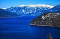
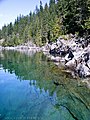
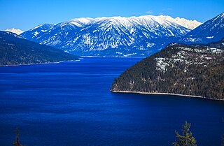
The Arrow Lakes in British Columbia, Canada, divided into Upper Arrow Lake and Lower Arrow Lake, are widenings of the Columbia River. The lakes are situated between the Selkirk Mountains to the east and the Monashee Mountains to the west. Beachland is fairly rare, and is interspersed with rocky headlands and steep cliffs. Mountain sides are heavily forested, and rise sharply to elevations around 2,600 metres.

New Denver is a village in the Central Kootenay region of British Columbia, Canada at the mouth of Carpenter Creek, on the east shore of Slocan Lake, in the West Kootenay region of southeastern British Columbia. The village is 47 kilometres (29 mi) west of Kaslo on Highway 31A, and 47 kilometres (29 mi) southeast of Nakusp and 32 kilometres (20 mi) northeast of Slocan on Highway 6.

Sandon is in the foothills of the Selkirk Mountains in the West Kootenay region of southeastern British Columbia. The near ghost town lies off BC Highway 31A, and is at the confluence of Sandon Creek into Carpenter Creek. By road, the place is about 14 kilometres (9 mi) east of New Denver and 43 kilometres (27 mi) west of Kaslo.
Silverton is a village about 5 kilometres (3 mi) south of New Denver in the West Kootenay region of southeastern British Columbia. The former steamboat landing is at the mouth of Silverton Creek on the eastern shore of Slocan Lake. The locality, on BC Highway 6 at the junction of BC Highway 31A, is about 95 kilometres (59 mi) by road north of Castlegar and 155 kilometres (96 mi) by road and ferry south of Revelstoke.

The Village of Slocan is in the West Kootenay region of southeastern British Columbia. The former steamboat landing and ferry terminal is at the mouth of Springer Creek, at the foot of Slocan Lake. The locality, on BC Highway 6 is about 69 kilometres (43 mi) by road north of Castlegar and 183 kilometres (114 mi) by road and ferry south of Revelstoke.
West Kootenay Transit System is the public transit system in Trail, Castlegar, Nelson, British Columbia and surrounding area. The transit services are operated from Trail, Castlegar, Nelson and serve Rossland, Warfield, Genelle, Montrose, Fruitvale, Salmo, Kaslo, Creston, Nakusp. Funding is provided under a partnership between the Regional District of Kootenay Boundary, Regional District of Central Kootenay and BC Transit. handyDART provides door-to-door transportation for people whose disability prevents them from using conventional bus service.
The Slocan Valley is a valley in the West Kootenay region of southeastern British Columbia.
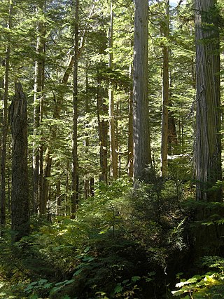
The Incomappleux River is in the West Kootenay region of southeastern British Columbia, Canada. Entering the Beaton Arm of Upper Arrow Lake, the river is a major tributary of the Columbia River. The upper reaches of the Incomappleux valley are home to some of the only inland temperate rainforest in the world.
Rosebery is an unincorporated community about 6 kilometres (4 mi) north of New Denver in the West Kootenay region of southeastern British Columbia. The former steamboat landing and ferry terminal is at the mouth of Wilson Creek on the eastern shore of Slocan Lake. The locality, on BC Highway 6, is about 106 kilometres (66 mi) by road north of Castlegar and 144 kilometres (89 mi) by road and ferry south of Revelstoke.
Three Forks is a ghost town at the junction of Carpenter, Seaton, and Kane creeks in the West Kootenay region of southeastern British Columbia. This former mining community, on BC Highway 31A, is by road about 8 kilometres (5 mi) east of New Denver and 38 kilometres (24 mi) west of Kaslo.
Gold Trails and Ghost Towns is a Canadian historical documentary show, created and produced by television station CHBC-TV in Kelowna, British Columbia for Canadian syndication and hosted by Mike Roberts with historian/storyteller Bill Barlee. The show was filmed in a studio which resembled an old trapper's cabin. Mike and Bill discussed prospectors and the history of British Columbia around 1900.
Lemon Creek is an unincorporated community on the east side of the Slocan River in the West Kootenay region of southeastern British Columbia. The locality is on BC Highway 6 about 8 kilometres (5 mi) south of Slocan, and 62 kilometres (39 mi) north of Castlegar.

SS Kootenay was a Canadian Pacific Railway (CPR) wooden-hulled sternwheeler that serviced the Arrow Lakes in British Columbia, Canada from 1897 to 1919. She was a large freight and passenger steamship and the first in a series of CPR riverboats built for the Arrow Lakes.