Carpenter Creek in western Virginia, now known as Potts Creek, was shown on a map of the area drawn by Joshua Fry and Peter Jefferson in 1751 and printed in 1755, and so called in the text of Thomas Jefferson's "Notes on the State of Virginia" that he prepared in the 1780s.[2] Carpenter's Creek is also shown as such on John Ballendine's map of the James River published c1772 and Thomas Hutchins' map of the western regions of Virginia published in 1778.[3]
The creek later acquired the name Potts Creek from a settler who lived further up the valley at the headwaters of the creek on Potts Mountain.[4] The Carpenter name persisted in occasional use through at least 1784, when in a report to George Washington it was confused with Dunlap's Creek,[5] and a grant was identified as located on Carpenter's "River" on July 1, 1793, but the name Potts Creek was in common use by the late 1790s.[6] Carpenter's Creek received its name from Joseph Carpenter, who on June 1, 1750, received a patent from the British Crown for 782 acres (3.16km2) of land on the south side of the Big Bend of Jackson's River (Jackson River (Virginia)) where the creek flows into the river.[7]
↑ Joshua Fry and Peter Jefferson: A map of the most inhabited part of Virginia containing the whole province of Maryland with part of Pensilvania, New Jersey and North Carolina. Drawn by Joshua Fry & Peter Jefferson in 1751, published by Thos. Jefferys, London, 1755
↑ Thomas Jefferson: Notes on the State of Virginia, first published in 1853 by J. W. Randolph, Richmond, Va., reprinted in revised form in 1861 by H. W. Derby, New York, N.Y., as part of Vol. VIII of The Writings of Thomas Jefferson, H. A. Washington, ed.
↑ The Library of Congress: West Virginia, The Centennial of Statehood, 1863-1963, An Exhibition of the Library of Congress, Superintendent of Documents, Washington, D.C., 1964, pp. 45-46, 68-69
↑ Raus McDill Hanson: Virginia Place Names, Derivations, Historical Uses, McClure Press, Verona, Va., 1969, p. 30.
↑ Archer Butler Hulbert: Washington and the West, The Century Co., New York, N.Y., 1905, p. 76.
↑ Larry G. Schuck: Hampshire and Hardy Counties (W) Va. Abstracts, Closson Press, Apollo, Pa., 1996; Oren F. Morton: A Centennial History of Allegheny County, Virginia, J. K. Ruebush Co., Dayton, Va., 1923, p. 88; and Terry L. Carpenter: "Carpenter's Creek, Old Augusta County, Virginia," in The Carpenter Chronicles, Bette Butcher Topp, ed., Vol. 7 (April 1991), pp. 11-12.
↑ Magazine of Virginia Genealogy, Vol. 30, No. 3 (August 1992), p. 204.
↑ U.S. Geological Survey. National Hydrography Dataset high-resolution flowline data. The National Map, accessed October 24, 2011
Fort Duquesne was a fort established by the French in 1754, at the confluence of the Allegheny and Monongahela rivers. It was later taken over by the British, and later the Americans, and developed as Pittsburgh in the U.S. state of Pennsylvania. Fort Duquesne was destroyed by the French before its British conquest during the Seven Years' War, known as the French and Indian War on the North American front. The British replaced it, building Fort Pitt between 1759 and 1761. The site of both forts is now occupied by Point State Park, where the outlines of the two forts have been laid in brick.
Peter Jefferson was a planter, cartographer and politician in colonial Virginia best known for being the father of the third president of the United States, Thomas Jefferson. The "Fry-Jefferson Map", created by Peter in collaboration with Joshua Fry in 1757, accurately charted the Allegheny Mountains for the first time and showed the route of "The Great Road from the Yadkin River through Virginia to Philadelphia distant 455 Miles"—what would later come to be known as the Great Wagon Road.
The Tygart Valley River — also known as the Tygart River — is a principal tributary of the Monongahela River, approximately 135 miles (217 km) long, in east-central West Virginia in the United States. Via the Monongahela and Ohio rivers, it is part of the watershed of the Mississippi River, draining an area of 1,329 square miles (3,440 km2) in the Allegheny Mountains and the unglaciated portion of the Allegheny Plateau.
William Churton was an early North Carolina surveyor.
James Maury (1717–1769) was a prominent Virginia educator and Anglican cleric during the American Colonial period and the progenitor of the prominent Maury political family. The Reverend James Maury was a figure in the notable lawsuit that became known as "The Parson's Cause" in 1763, in which the young attorney Patrick Henry argued that the colony had the right to establish its own method of payment to clergy.
Thomas Jefferys, "Geographer to King George III", was an English cartographer who was the leading map supplier of his day. He engraved and printed maps for government and other official bodies and produced a wide range of commercial maps and atlases, especially of North America.
State Route 18 is a primary state highway in the U.S. state of Virginia. Known for most of its length as Potts Creek Road, the state highway runs 25.86 miles (41.62 km) from SR 311 in Paint Bank north to U.S. Route 60 and US 220 in Covington.
Colonel Joshua Fry (1699–1754) was an English-born American adventurer who became a professor, then real estate investor and local official in the colony of Virginia. Although he served several terms in the House of Burgesses, he may be best known as a surveyor and cartographer who collaborated with Peter Jefferson, the father of future U.S. president Thomas Jefferson. After Fry’s death on a military expedition, George Washington became commanding officer of the Virginia Regiment, a key unit in what became the French and Indian War.
Great Alamance Creek, also called Big Alamance Creek, is a 37-mile long creek that is a tributary of the Haw River. The creek's headwaters are in Guilford County, but it flows primarily through Alamance County, North Carolina. It is a major source of water for the cities of Burlington and Greensboro through the Lake Mackintosh Reservoir. It was called "Alamance" after an old local Native American word used to describe the blue-colored mud in the bottom of the creek.
Mountain Lake Wilderness is a U.S. Wilderness Area in the George Washington and Jefferson National Forests. The wilderness area is located next to privately owned Mountain Lake, and consists of 8,314 acres (3,365 ha) in Virginia and 2,721 acres (1,101 ha) in West Virginia.
Paint Bank is an unincorporated community in northern Craig County, Virginia, United States. It is located at the intersection of State Route 18 and State Route 311 northwest of the town of New Castle, the county seat. The village is located between Potts Mountain and Peters Mountain. It is one of the westernmost communities of the Roanoke metropolitan area.
Streets Run is a 5.2-mile-long (8.4 km) tributary of the Monongahela River in Allegheny County, Pennsylvania. This urban stream drains portions of the communities of Pittsburgh, Baldwin, Brentwood, West Mifflin and Whitehall, an area of about ten square miles.
Potts Creek is a 46-mile-long (74 km) tributary of the Jackson River in western Virginia. Via the Jackson River, it is part of the James River watershed, flowing to Chesapeake Bay. The creek rises in Monroe County, West Virginia, south of Waiteville, and flows northeast through Craig County and Alleghany County in Virginia, joining the Jackson River at Covington.
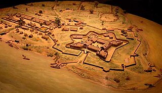
Fort Carpenter, Alleghany County, Virginia, was built about 1755-1756 by Joseph Carpenter, who migrated from the Province of New York to "the big bend" of the Jackson River on the Virginia frontier about 1745-1746. It was actually a fortified house, or blockhouse. Located on a low bluff near the mouth of Carpenter Creek, it was later known as Cedar Hill. Logs and stones from the original structure were used in the later dwelling now on the site. A young George Washington visited the string of frontier forts during the French and Indian War in 1756, inspecting Fort Young on the north side of the Jackson River, and Fort Carpenter, described as a fortified house, on the south side. In 1856, Joseph Hannah Carpenter graduated from the Virginia Military Institute as a civil engineer, and later went on to serve as an artillery cadet under the command of Stonewall Jackson.
Dunlap Creek is a 25.9-mile-long (41.7 km) tributary of the Jackson River in the U.S. state of Virginia. It is part of the James River watershed.
McCulloch's Path was an early colonial route through Western Maryland, referenced by George Washington in his diary in September 1784.
Catherine "Kate" Carpenter, born probably ca. 1730s, died 1784, was a frontier wife and mother for whom Kate's Mountain in Greenbrier County, West Virginia is named.
John Peter Salling, born Johan Peter Saling and sometimes referred to as John Peter Salley, Sayling, Sallings, and Sallee, was a German explorer known for being among the first Europeans to visit parts of Virginia, West Virginia and Kentucky. He was imprisoned by the French in New Orleans on charges of spying and escaped together with another prisoner, taking eight months to finally reach his home in Virginia. His detailed journal describing his journeys of exploration was lost twice, and each time Salling was able to reconstruct it from memory. Salling's journal was used as a source in the creation of early maps of Virginia and eastern North America.
The Mountain Lake Wilderness Cluster is a region recognized by The Wilderness Society for its unique waterfalls, vistas, trout stream and wildlife habitat. The heart of the region is the Mountain Lake Wilderness, the largest wilderness in the George Washington and Jefferson National Forests. These public lands are enhanced by the presence of private lands which are preserved to maintain their natural integrity. The region includes the Mountain Lake Biological Station that studies distinctive wildlife and ecology of the area.
The North Carolina–Tennessee–Virginia Corners is a tripoint at which North Carolina, Tennessee and Virginia meet. The landmark is located in the Iron Mountains, and is roughly 16 miles north of Snake Mountain, and 8 miles southwest of Mount Rogers.
This page is based on this Wikipedia article Text is available under the CC BY-SA 4.0 license; additional terms may apply. Images, videos and audio are available under their respective licenses.