
Alice Lake Provincial Park is a provincial park in British Columbia, Canada.

Champion Lakes Provincial Park is a provincial park in the West Kootenay region of British Columbia, Canada, northeast of the city of Trail in the province's West Kootenay region.

Sx̱ótsaqel/Chilliwack Lake Provincial Park is a provincial park in British Columbia, Canada. Covering 92.58 km2, the park is located 150 km east of Vancouver in the Chilliwack River Valley.

Davis Lake Provincial Park is a 185 acres (0.75 km2) park in British Columbia, Canada, established as a protected provincial park in October 1963. It is located east of the southern end of Stave Lake, northeast of Mission, British Columbia, approximately 18 km north on Sylvester Rd from BC Highway 7. There are campgrounds and beaches at the south end of the lake, access is walk-in only via a 1 km unmaintained gravel road.
Gladstone Provincial Park is a provincial park in British Columbia, Canada, surrounding and north of the north end of Christina Lake in that province's Boundary Country.
James Chabot Provincial Park is a provincial park in British Columbia, Canada. Formerly Athalmer Beach Provincial Park, it is located in Invermere at the northeast end of Windermere Lake in the Columbia Valley region of the East Kootenay. Windermere Lake Provincial Park is located at the lake's southwestern end.
Jewel Lake Provincial Park is a provincial park bordering the northwestern end of Jewel Lake in the Boundary region of south central British Columbia. The park, via BC Highway 3 and Jewel Lake Rd, is about 14 kilometres (8.7 mi) northeast of Greenwood and 48 kilometres (30 mi) northwest of Grand Forks
Kootenay Lake Provincial Park is a provincial park in British Columbia, Canada. It encompasses five widely dispersed parks around Kootenay Lake: Kootenay Lake Provincial Park, Kootenay Lake Provincial Park, Kootenay Lake Provincial Park, Kootenay Lake Provincial Park, and Kootenay Lake Provincial Park.
Kianuko Provincial Park is a provincial park in British Columbia, Canada.
Kikomun Creek Provincial Park is a provincial park in British Columbia, Canada.
Lockhart Creek Provincial Park is a provincial park in British Columbia, Canada, located adjacent to Lockhart Beach Provincial Park, 40 km north of Creston, British Columbia on the east shore of Kootenay Lake.
Nancy Greene Provincial Park is a provincial park in British Columbia, Canada, located approximately 27 km (17 mi) northwest of the city of Rossland and 31 km (19 mi) west of the city of Castlegar in that province's West Kootenay region, at the junction of Highway 3 and Highway 3B. It is named for Nancy Greene, Canadian Olympic medallist in downhill skiing, who is a native of Rossland.
Norbury Lake Provincial Park is a 97-hectare (240-acre) provincial park in British Columbia, Canada.

Pilot Bay Provincial Park is a provincial park in British Columbia, Canada.
Syringa Park is a provincial park on the east shore of Lower Arrow Lake in the West Kootenay region of southeastern British Columbia. At the foot of the Norns Range, Tulip Creek passes through the centre, and Syringa Creek is closer to the southeastern boundary. The park is about 19 kilometres (12 mi) west of Castlegar via Broadwater Rd.

Stagleap Provincial Park is a provincial park in British Columbia, Canada. The park is approximately 1133 hectares. It is 34 kilometers west of Creston.

Christina Lake is a lake located along the Crowsnest Highway in the south-central area of British Columbia known as Boundary Country, which separates the Okanagan region from the Kootenays. It is located 23 kilometers east of Grand Forks, just 1 km north of the United States border. The region experiences very hot, dry summers which results in July and early August water temperatures averaging in the 23 °C range. Divers will experience thermoclines beginning at a depth of approximately 10 feet in the summer. The lake is renowned as the warmest tree-lined lake in British Columbia.
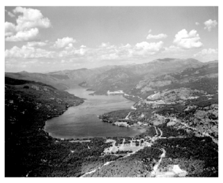
Christina Lake is an unincorporated recreational area in the Boundary Country of the West Kootenay region of British Columbia, Canada. It is located on Crowsnest Highway, 20 kilometres (12 mi) east of Grand Forks and 73 kilometres (45 mi) southwest of Castlegar.

Buffalo Pound Provincial Park is in southern Saskatchewan, Canada, about 30 kilometres (19 mi) north-east of Moose Jaw and 86 kilometres (53 mi) north-west of the city of Regina. Access to the provincial park is from Highways 301 and 202.
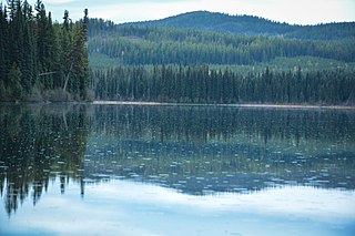
There are many lakes named Long Lake in British Columbia, Canada.


