The basin of the Shuswap River lies northeast of the Okanagan Valley in British Columbia, originating in the central Monashee Mountains. It is the upper part of the drainage better known to British Columbians as belonging to Shuswap Lake and the South Thompson River. The river's drainage basin is over 1,969 square kilometres (760 sq mi) in area.

Adams Lake Provincial Park is a provincial park in British Columbia, Canada. It encompasses three distinct parks: Adams Lake Provincial Park, Adams Lake Marine Provincial Park, and Adams Lake Marine Provincial Park.
Ellison Provincial Park is a provincial park in British Columbia, Canada, located on the east side of Okanagan Lake to the south of the city of Vernon. The park contains approximately 219 hectares (2.19 km2) of land, 200 ha. of it upland, 19 ha. of it foreshore.
Eneas Lakes Provincial Park is a provincial park in British Columbia, Canada, located west of the town of Peachland, to the south of Peachland Creek. The park is approximately 1036 ha. in size and was established in 1968. The Eneas Lakes lie at the head of Finlay Creek.
Grohman Narrows Provincial Park is a provincial park in British Columbia, Canada. It is located 5 km from the City of Nelson.

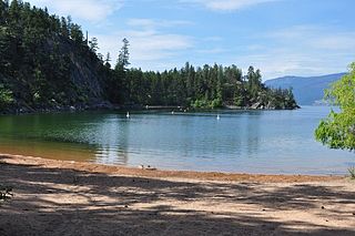
Kalamalka Lake Provincial Park and Protected Area is a provincial park in Coldstream, British Columbia, Canada. Located within the Okanagan region, the park encompasses a land area of about 978 hectares of pristine natural areas in the North Okanagan Regional District. Kalamalka Lake Provincial Park and Protected Area adopted its current name from Kalamalka Lake, for which it is located on its shore. During the process of entering summer, calcium carbonate forms crystals that reflect sunlight and create the vivid blue and green colours. Temperature changes in the fall and the spring sometimes create ribbons of deep blue colour in the lake, seen from the park.
Kekuli Bay Provincial Park, formerly Kalamalka West Provincial Park, is a provincial park in British Columbia, Canada, located on the west shore of Kalamalka Lake on BC Highway 97 south of Vernon. The lake is popular for waterskiing and boating, and the park includes a boat launch, as well as a campground with a view of the lake. The park was established in 1990. Its size is about 57 hectares.

Marble River Provincial Park is a provincial park in British Columbia, Canada. The park is located on northern Vancouver Island. It is 14.19 km2 (5.48 sq mi) in area. The park protects an eagle nesting habitat near Quatsino Narrows in Quatsino Sound, a steelhead fishery, and an extensive waterfowl habitat. A 4.2 km (2.6 mi)-long biking or walking trail is available, as well as opportunities for wildlife viewing.
Monte Lake Provincial Park is a provincial park in British Columbia, Canada, located on the east side of Monte Lake and to the south of the community of Monte Lake, British Columbia which is at the north end of the lake. About five hectares in size, it protects an area of Ponderosa pine and grasslands.

Niskonlith Lake Provincial Park is a provincial park in British Columbia, Canada, located southwest of the town of Chase. The park makes up an area of 275 hectares.

Pillar Provincial Park is a provincial park in British Columbia, Canada. It is located 11 km (6.8 mi) north of Highway 97 at Falkland. The park area is 2.34 hectares and protects a stone pillar on the hillside above Pillar Lake.
Pritchard Provincial Park is a provincial park in British Columbia, Canada, located on the north side of the South Thompson River between the communities of Monte Creek, to the west, and Chase, to the east. The park lies approximately 40 kilometres (25 mi) northeast of the city of Kamloops. The park itself is split into two geographically separated sections.

Shuswap Lake Provincial Park is a provincial park in British Columbia, Canada. It is located in the community of Scotch Creek, on the north shore of the main arm of Shuswap Lake in the Southern Interior of BC. The park is about 45 minutes north of Salmon Arm, and about 1 hour east of Kamloops. The park contains a large campground with approximately 275 camping sites, as well as a large sand and gravel beach and day use/picnic area. It is a very popular park, with many thousands of people, primarily from BC and Alberta, camping there every year.
Shuswap Lake Marine Provincial Park is a provincial park in British Columbia, Canada, comprising 894 ha. The Park has a variety of amenities including boat launch ramps, picnic areas, and 27 campsites around the perimeter of Shuswap Lake. The lake's name and that of the surrounding Shuswap Country is from the Shuswap people (Secwepemc), the most northern of the Salishan speaking people.
Sunnybrae Provincial Park is a provincial park in British Columbia, Canada, located on the northern side of the Salmon Arm of Shuswap Lake, near the city of Salmon Arm. Sunnybrae is a day use park with washrooms, picnic tables, playground and swimming area.
The Tlʼesqox First Nation is a Tsilhqotʼin community located west of the Fraser Canyon in the Chilcotin region of the Canadian province of British Columbia. It is a member of the Carrier-Chilcotin Tribal Council, which includes both Tsilhqotʼin and Carrier (Dakelh) communities.
The Nazko First Nation is a First Nations government of the Dakelh people in the north-central Interior of British Columbia. Its reserves are located around the community of Nazko, British Columbia, which is 120 km west of Quesnel and southwest of Prince George.
Alouette Lake, originally Lillooet Lake and not to be confused with the lake of that name farther north, is a lake and reservoir in Maple Ridge, British Columbia, Canada. It is at the southeastern foot of the mountain group known as the Golden Ears and is about 16 km in length on a northeast–southwest axis. It, and the Alouette River, were renamed in 1914 to avoid confusion with the larger river and lake farther north, with "Alouette", the French word for "lark", being chosen as being melodious and reminiscent of the original name in tone.

Nitinat Lake is a large lake and inlet on the southwestern coast of Vancouver Island, British Columbia, Canada. The lake is about 150 km (93 mi) northwest by road from Victoria, BC's capital on the southern tip of Vancouver Island, and about 60 km (37 mi) southwest by road from the town of Lake Cowichan. The city of Port Alberni is about 80 km (50 mi) by road to the north.

