
Aluche is a barrio of the city of Madrid, situated in the southwest of the city, in the Latina district. It is bounded by the barrios of Campamento, Las Águilas, Lucero, Los Cármenes, and the Carabanchel district. Casa de Campo is also nearby. Aluche takes its name from the Luche creek that formerly flowed through the neighbourhood.

Porteau Cove Provincial Park is a provincial park located along the eastern shore of Howe Sound in British Columbia, Canada.
Charlie Lake Provincial Park is a provincial park in British Columbia, Canada, established on the western shore of Charlie Lake. It is roughly 92 hectares in size.
Greenstone Mountain Provincial Park is a provincial park in British Columbia, Canada, located south of Kamloops Lake on the northern edge of the Thompson Plateau.
Hitchie Creek Provincial Park is a provincial park in the Canadian province of British Columbia, west of the north end of Nitinat Lake on the west coast of Vancouver Island, north-east of Bamfield.

McConnell Lake Provincial Park is a provincial park in British Columbia, Canada, located near Lac Le Jeune between Kamloops and Merritt, near BC Highway 5.

Monck Provincial Park is a provincial park in British Columbia, Canada, located at Nicola Lake near the town of Merritt. The park's campground is one of those which accepts reservations. Activities including fishing, camping and hiking. Natural features other than Nicola Lake include lava beds associated with the Chilcotin Group.
Mount Savona Provincial Park is a provincial park in British Columbia, Canada.

Niskonlith Lake Provincial Park is a provincial park in British Columbia, Canada, located southwest of the town of Chase.
Walhachin Oxbows Provincial Park is a provincial park in British Columbia, Canada.
Walloper Lake Provincial Park is a provincial park in British Columbia, Canada. Walloper lake is a small lake located on the Trans-Canada Highway, 38 km from the city of Kamloops.
Schoolhouse Lake Provincial Park, formerly known as Lang Lake Provincial Park, is a provincial park in British Columbia, Canada.
Steelhead Provincial Park is a provincial park in British Columbia, Canada, located at the west end of Kamloops Lake near the town of Savona.
Takla Lake Marine Provincial Park is a provincial park in British Columbia, Canada. Located northeast of the town of Smithers and roughly parallel to Babine Lake to its west/southwest, it comprises three sites on Takla Lake in the northwestern part of the Omineca Country of the province's North-Central Interior. The three sites are the Sandy Point Site, containing about 160 ha, Takla Lake West containing about 41 ha, and White Bluff, containing about 349 ha.
Tunkwa Provincial Park is a provincial park in British Columbia, Canada, located on the northern Thompson Plateau between the towns of Logan Lake (S) and Savona (N).
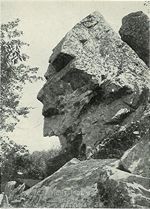
Profile Rock was a 50-foot high granite rock formation located in Freetown, Massachusetts just outside Assonet village and near the Freetown State Forest. Local Wampanoags believe it to be the image of Chief Massasoit. The Wampanoags occupied the region of Rhode Island and Massachusetts bounded by Narragansett Bay to the west and the Atlantic Ocean to the east, and Chief Massasoit was a close friend to the early Pilgrim settlers.
Balderson Station is an unincorporated community in El Dorado County, California. It is located 5 miles (8 km) east-northeast of Georgetown, at an elevation of 3294 feet.

Bluff, also known as Agookauchuk, was a 20th-century mining town in Nome Census Area, Alaska. It was built at the mouth of Daniels Creek on the north shore of Norton Sound on the Seward Peninsula in the summer of 1900, as a result of the Nome Gold Rush. The town was located 55 miles (89 km) southeast of Nome. The settlement was served by a post office for eighteen years, from 1901 to 1919.
Adel is an unincorporated community in eastern Franklin Township, Owen County, in the U.S. state of Indiana. It lies near the bridge on County Road 150 West over Raccoon Creek, which is a community nearly ten miles southwest of the city of Spencer, the county seat. Its elevation is 541 feet (165 m), and it is located at 39°11′31″N86°47′45″W.
