List of provincial parks of British Columbia Central Interior

Last updated

The list of provincial parks of the British Columbia Central Interior contains the provincial parks located within this geographic region of the province of British Columbia. It includes parks from the three regional districts of Bulkley-Nechako, Cariboo, and Fraser-Fort George. These parks are administered by BC Parks under the jurisdiction of the Ministry of Environment and Climate Change Strategy.

Contents

The most visited provincial park of this region is Mount Robson Provincial Park with 205,559 total visitors and 64,673 overnight campers during the 2017/2018 season. [1]

List of parks

Park nameClassificationRegional districtsCoordinatesSizeEstablishedRemarks
haacres
Ancient Forest/Chun T'oh Whudujut Provincial Park Provincial Park
Protected Area
Fraser-Fort George 53°45′44″N121°13′09″W / 53.76222°N 121.21917°W / 53.76222; -121.21917 (Ancient Forest/Chun T'oh Whudujut Provincial Park) 11,87529,3402016Protects a portion of the North American inland temperate rainforest.
Arctic Pacific Lakes Provincial Park Provincial Park Fraser-Fort George 54°22′59″N121°31′01″W / 54.383°N 121.517°W / 54.383; -121.517 (Arctic Pacific Lakes Provincial Park) 13,88734,3202000
Atna River Provincial Park Provincial Park
Protected Area
Bulkley-Nechako 53°59′13″N127°53′53″W / 53.987°N 127.898°W / 53.987; -127.898 (Atna River Provincial Park) 21,09252,1202008
Babine Lake Marine Provincial Park Marine Provincial Park Bulkley-Nechako 54°30′54″N125°42′00″W / 54.515°N 125.70°W / 54.515; -125.70 (Babine Lake Marine Provincial Park) 1052601993
Babine Mountains Provincial Park Provincial Park Bulkley-Nechako 54°55′59″N126°55′59″W / 54.933°N 126.933°W / 54.933; -126.933 (Babine Mountains Provincial Park) 31,14676,9601984
Babine River Corridor Provincial Park Provincial Park Bulkley-Nechako 55°36′00″N127°01′59″W / 55.60°N 127.033°W / 55.60; -127.033 (Babine River Corridor Provincial Park) 15,35937,9501999
Beaumont Provincial Park Provincial Park Bulkley-Nechako 54°03′00″N124°37′01″W / 54.05°N 124.617°W / 54.05; -124.617 (Beaumont Provincial Park) 1784401960
Beaver Valley Provincial Park Provincial Park Cariboo 52°36′37″N121°59′45″W / 52.61028°N 121.99583°W / 52.61028; -121.99583 (Beaver Valley Provincial Park) 7671,9002013
Big Creek Provincial Park Provincial Park
Ecological Reserve
Thompson-Nicola 51°18′N123°10′W / 51.300°N 123.167°W / 51.300; -123.167 (Big Creek Provincial Park) 68,175168,4601990
Bijoux Falls Provincial Park Provincial Park Fraser-Fort George 55°18′00″N122°40′01″W / 55.30°N 122.667°W / 55.30; -122.667 (Bijoux Falls Provincial Park) 40991956
Bobtail Mountain Provincial Park Provincial Park Fraser-Fort George 53°40′01″N123°24′00″W / 53.667°N 123.40°W / 53.667; -123.40 (Bobtail Mountain Provincial Park) 1,3603,4002000
Bowron Lake Provincial Park Provincial Park Cariboo 53°10′01″N121°04′59″W / 53.167°N 121.083°W / 53.167; -121.083 (Bowron Lake Provincial Park) 139,700345,0001961
Bridge Lake Provincial Park Provincial Park Cariboo 51°28′59″N120°42′00″W / 51.483°N 120.70°W / 51.483; -120.70 (Bridge Lake Provincial Park) 4051,0001956
Bull Canyon Provincial Park Provincial Park Cariboo 52°05′31″N123°22′30″W / 52.092°N 123.375°W / 52.092; -123.375 (Bull Canyon Provincial Park) 3438501993
Burns Lake Provincial Park Provincial Park Bulkley-Nechako 54°12′00″N125°43′01″W / 54.20°N 125.717°W / 54.20; -125.717 (Burns Lake Provincial Park) 651602001
Call Lake Provincial Park Provincial Park Bulkley-Nechako 54°45′50″N127°05′28″W / 54.764°N 127.091°W / 54.764; -127.091 (Call Lake Provincial Park) 621501999
Canim Beach Provincial Park Provincial Park Cariboo 51°49′01″N120°52′01″W / 51.817°N 120.867°W / 51.817; -120.867 (Canim Beach Provincial Park) 6151956
Cariboo Mountains Provincial Park Provincial Park Cariboo 52°52′59″N120°31′01″W / 52.883°N 120.517°W / 52.883; -120.517 (Cariboo Mountains Provincial Park) 113,469280,3901995
Cariboo Nature Provincial Park Provincial Park Cariboo 51°52′53″N121°39′52″W / 51.88139°N 121.66444°W / 51.88139; -121.66444 (Cariboo Nature Provincial Park) 892201965
Cariboo River Provincial Park Provincial Park Cariboo 52°52′01″N121°12′40″W / 52.867°N 121.211°W / 52.867; -121.211 (Cariboo River Provincial Park) 3,2117,9301995
Carp Lake Provincial Park Provincial Park Fraser-Fort George 54°47′00″N123°22′01″W / 54.7833°N 123.367°W / 54.7833; -123.367 (Carp Lake Provincial Park) 38,14994,2701973
Cedar Point Provincial Park Class C Provincial Park Cariboo 52°34′41″N121°32′10″W / 52.578°N 121.536°W / 52.578; -121.536 (Cedar Point Provincial Park) 8201962
Close To The Edge Provincial Park and Protected Area Provincial Park
Protected Area
Fraser-Fort George 54°03′49″N121°02′23″W / 54.0635°N 121.0397°W / 54.0635; -121.0397 (Close To The Edge Provincial Park) 7021,7302001Protects Close To The Edge cave.
Cottonwood River Provincial Park Provincial Park Cariboo 53°10′01″N122°30′00″W / 53.167°N 122.50°W / 53.167; -122.50 (Cottonwood River Provincial Park) 661601956
Crooked River Provincial Park Provincial Park Fraser-Fort George 54°28′30″N122°40′59″W / 54.475°N 122.683°W / 54.475; -122.683 (Crooked River Provincial Park) 9632,3801965
Dahl Lake Provincial Park Provincial Park Fraser-Fort George 53°46′30″N123°17′46″W / 53.775°N 123.296°W / 53.775; -123.296 (Dahl Lake Provincial Park) 1,5833,9101981
Dead Man’s Island Provincial Park Provincial Park Bulkley-Nechako 54°12′26″N125°43′57″W / 54.20722°N 125.73250°W / 54.20722; -125.73250 (Dead Man’s Island Provincial Park) 12.51933One of the smallest provincial parks in British Columbia.
Donnely Lake Provincial Park Provincial Park Cariboo 51°45′16″N120°40′24″W / 51.75444°N 120.67333°W / 51.75444; -120.67333 (Donnely Lake Provincial Park) 8142,0102013
Dragon Mountain Provincial Park Provincial Park Cariboo 52°52′58″N122°20′15″W / 52.88278°N 122.33750°W / 52.88278; -122.33750 (Dragon Mountain Provincial Park) 1,7734,3802013
Driftwood Canyon Provincial Park Provincial Park Bulkley-Nechako 54°49′34″N127°01′19″W / 54.826°N 127.022°W / 54.826; -127.022 (Driftwood Canyon Provincial Park) 21521967Protects fossil beds along its namesake creek.
Entiako Provincial Park Provincial Park Bulkley-Nechako 53°15′00″N125°25′59″W / 53.25°N 125.433°W / 53.25; -125.433 (Entiako Provincial Park) 126,023311,4101999
Erg Mountain Provincial Park Provincial Park Fraser-Fort George 53°34′16″N120°54′29″W / 53.571°N 120.908°W / 53.571; -120.908 (Erg Mountain Provincial Park) 1,0112,5002000
Eskers Provincial Park Provincial Park Fraser-Fort George 54°04′01″N123°10′01″W / 54.067°N 123.167°W / 54.067; -123.167 (Eskers Provincial Park) 4,0449,9901987
Ethel F. Wilson Memorial Provincial Park Memorial Provincial Park Bulkley-Nechako 54°25′05″N125°41′13″W / 54.418°N 125.687°W / 54.418; -125.687 (Ethel F. Wilson Memorial Provincial Park) 33821953
Evanoff Provincial Park Provincial Park Fraser-Fort George 54°05′03″N121°20′16″W / 54.0841°N 121.3377°W / 54.0841; -121.3377 (Evanoff Provincial Park) 1,4733,6402000
Finger-Tatuk Provincial Park Provincial Park Bulkley-Nechako 53°29′38″N124°12′58″W / 53.494°N 124.216°W / 53.494; -124.216 (Finger-Tatuk Provincial Park) 17,15142,3801999
Flat Lake Provincial Park Provincial Park Cariboo 51°30′04″N121°31′01″W / 51.501°N 121.517°W / 51.501; -121.517 (Flat Lake Provincial Park) 4,27510,5601995
Fort George Canyon Provincial Park Provincial Park Fraser-Fort George 53°40′59″N122°43′01″W / 53.683°N 122.717°W / 53.683; -122.717 (Fort George Canyon Provincial Park) 1784402000
François Lake Provincial Park Provincial Park
Protected Area
Bulkley-Nechako 53°58′01″N125°10′01″W / 53.967°N 125.167°W / 53.967; -125.167 (François Lake Provincial Park) 7,27217,9701999
Fraser River Provincial Park Provincial Park
Ecological Reserve
Fraser-Fort George 53°28′59″N122°43′16″W / 53.483°N 122.721°W / 53.483; -122.721 (Fraser River Provincial Park) 5,07612,5402000
Heather-Dina Lakes Provincial Park Provincial Park
Ecological Reserve
Fraser-Fort George 55°30′40″N123°17′46″W / 55.511°N 123.296°W / 55.511; -123.296 6,03414,9102001
Horsefly Lake Provincial Park Provincial Park Cariboo 52°23′20″N121°17′17″W / 52.389°N 121.288°W / 52.389; -121.288 1864601974
Itcha Ilgachuz Provincial Park Provincial Park Cariboo 52°42′00″N124°49′59″W / 52.70°N 124.833°W / 52.70; -124.833 109,063269,5001995
Jackman Flats Provincial Park Provincial Park Fraser-Fort George 52°57′00″N119°25′01″W / 52.95°N 119.417°W / 52.95; -119.417 6151,5202000Protects a unique sand dune ecosystem.
Junction Sheep Range Provincial Park Provincial Park Cariboo 51°48′00″N122°25′19″W / 51.80°N 122.422°W / 51.80; -122.422 4,77411,8001995
Kakwa Provincial Park Provincial Park
Protected Area
Fraser-Fort George 54°02′39″N120°21′16″W / 54.0443°N 120.3545°W / 54.0443; -120.3545 170,890422,3001987Part of the Kakwa-Willmore Interprovincial Park.
Kluskoil Lake Provincial Park Provincial Park Cariboo 53°13′01″N123°54′00″W / 53.217°N 123.90°W / 53.217; -123.90 15,54838,4201995
Lac La Hache Provincial Park Provincial Park Cariboo 51°51′32″N121°38′17″W / 51.859°N 121.638°W / 51.859; -121.638 24591956
Little Andrews Bay Marine Provincial Park Marine Provincial Park Bulkley-Nechako 53°48′06″N126°36′40″W / 53.80167°N 126.61111°W / 53.80167; -126.61111 (Little Andrews Bay Marine Provincial Park) 102.12521999
Monkman Provincial Park Provincial Park Fraser-Fort George 54°32′54″N121°09′28″W / 54.5482°N 121.1578°W / 54.5482; -121.1578 62,867155,3501981
Moose Valley Provincial Park Provincial Park Cariboo 51°39′N121°39′W / 51.65°N 121.65°W / 51.65; -121.65 2,5006,2001995
Morice Lake Provincial Park Provincial Park
Ecological Reserve
Bulkley-Nechako 53°58′16″N127°38′45″W / 53.9711°N 127.6458°W / 53.9711; -127.6458 52,788130,4402008
Mount Blanchet Provincial Park Provincial Park Bulkley-Nechako 55°16′59″N125°52′01″W / 55.283°N 125.867°W / 55.283; -125.867 24,77461,2202001
Mount Pope Provincial Park Provincial Park Bulkley-Nechako 54°29′38″N124°20′31″W / 54.494°N 124.342°W / 54.494; -124.342 2,0305,0002001
Mount Robson Provincial Park Provincial Park
Protected Area
Fraser-Fort George 53°02′02″N119°13′55″W / 53.034°N 119.232°W / 53.034; -119.232 225,777557,9101913Protects Mount Robson, the highest peak of the Canadian Rockies. Part of the Canadian Rocky Mountain Parks World Heritage Site.
Mount Terry Fox Provincial Park Provincial Park Fraser-Fort George 52°56′42″N119°15′29″W / 52.945°N 119.258°W / 52.945; -119.258 1,9304,8001982
Mudzenchoot Provincial Park Provincial Park Bulkley-Nechako 54°51′50″N124°22′12″W / 54.864°N 124.37°W / 54.864; -124.37 6441,5902001
Nadina Mountain Provincial Park Provincial Park Bulkley-Nechako 54°05′56″N126°52′56″W / 54.09889°N 126.88222°W / 54.09889; -126.88222 2,7896,8902008
Nation Lakes Provincial Park Provincial Park Bulkley-Nechako 55°27′29″N125°24′00″W / 55.458°N 125.40°W / 55.458; -125.40 19,39847,9302004
Nazko Lake Provincial Park Provincial Park Cariboo 52°25′52″N123°33′18″W / 52.431°N 123.555°W / 52.431; -123.555 12,41930,6901995
Nenikëkh/Nanika-Kidprice Provincial Park Provincial Park Bulkley-Nechako 53°56′18″N127°24′11″W / 53.9383°N 127.403°W / 53.9383; -127.403 17,00642,0202008
Netalzul Meadows Provincial Park Provincial Park Bulkley-Nechako 55°34′N127°00′W / 55.57°N 127.00°W / 55.57; -127.00 2977301999
Nilkitkwa Lake Provincial Park Provincial Park Bulkley-Nechako 55°24′N126°40′W / 55.40°N 126.66°W / 55.40; -126.66 10.3251999
Nuntsi Provincial Park Provincial Park Cariboo 51°44′38″N123°46′59″W / 51.744°N 123.783°W / 51.744; -123.783 20,57050,8001995
Old Man Lake Provincial Park Provincial Park
Protected Area
Bulkley-Nechako 48°18′08″N79°52′38″W / 48.30222°N 79.87722°W / 48.30222; -79.87722 3268102008
Omineca Provincial Park and Protected Area Provincial Park
Protected Area
Bulkley-Nechako 55°51′47″N124°38′02″W / 55.863°N 124.634°W / 55.863; -124.634 135,434334,6602001
Paarens Beach Provincial Park Provincial Park Bulkley-Nechako 54°25′16″N124°22′41″W / 54.421°N 124.378°W / 54.421; -124.378 501201972
Pine Le Moray Provincial Park Provincial Park Fraser-Fort George 55°22′27″N122°33′45″W / 55.3741°N 122.5624°W / 55.3741; -122.5624 43,245106,8602000
Pinnacles Provincial Park Provincial Park Cariboo 52°58′44″N122°33′29″W / 52.979°N 122.558°W / 52.979; -122.558 124.39307.41969Protects a collection of prominent hoodoos.
Ptarmigan Creek Provincial Park and Protected Area Provincial Park
Protected Area
Fraser-Fort George 53°29′35″N120°53′24″W / 53.493°N 120.890°W / 53.493; -120.890 4,63311,4502001Protects the complete watershed of the east branch of Ptarmigan Creek, a tributary to the Fraser River.
Puntchesakut Lake Provincial Park Provincial Park Cariboo 52°58′59″N122°55′59″W / 52.983°N 122.933°W / 52.983; -122.933 38941980
Punti Island Provincial Park Provincial Park Cariboo 52°12′27″N123°54′39″W / 52.20750°N 123.91083°W / 52.20750; -123.91083 12302013
Purden Lake Provincial Park Provincial Park Fraser-Fort George 53°55′44″N121°54′40″W / 53.929°N 121.911°W / 53.929; -121.911 2,5216,2301971
Rainbow Alley Provincial Park Provincial Park Bulkley-Nechako 55°20′06″N126°38′28″W / 55.335°N 126.641°W / 55.335; -126.641 1102701999
Rainbow/Q'iwentem Provincial Park Provincial Park Cariboo 51°38′9″N120°48′22″W / 51.63583°N 120.80611°W / 51.63583; -120.80611 3859502013
Rearguard Falls Provincial Park Provincial Park Fraser-Fort George 52°58′26″N119°21′25″W / 52.974°N 119.357°W / 52.974; -119.357 461101991
Red Bluff Provincial Park Provincial Park Bulkley-Nechako 54°51′14″N126°10′52″W / 54.854°N 126.181°W / 54.854; -126.181 1483701978
Rubyrock Lake Provincial Park Provincial Park Bulkley-Nechako 54°41′10″N125°20′46″W / 54.686°N 125.346°W / 54.686; -125.346 41,221101,8602001
Ruth Lake Provincial Park Provincial Park Cariboo 51°49′59″N121°01′59″W / 51.833°N 121.033°W / 51.833; -121.033 30741959
Schoolhouse Lake Provincial Park Provincial Park Cariboo 51°53′00″N120°59′46″W / 51.8833°N 120.996°W / 51.8833; -120.996 5,10612,6201995
Slim Creek Provincial Park Provincial Park Fraser-Fort George 53°45′58″N121°11′17″W / 53.766°N 121.188°W / 53.766; -121.188 5061,2502000
Small River Caves Provincial Park Provincial Park Fraser-Fort George 53°11′13″N119°30′22″W / 53.187°N 119.506°W / 53.187; -119.506 1,8184,4902000Protects a remote cave system.
Sowchea Bay Provincial Park Provincial Park Fraser-Fort George 54°25′N124°27′W / 54.42°N 124.45°W / 54.42; -124.45 13321989
Stuart Lake Marine Provincial Park Marine Provincial Park Bulkley-Nechako 54°38′56″N125°00′29″W / 54.649°N 125.008°W / 54.649; -125.008 7971,9702001
Stuart River Provincial Park Provincial Park Bulkley-Nechako 54°03′00″N123°37′01″W / 54.05°N 123.617°W / 54.05; -123.617 20,98451,8501999
Sugarbowl - Grizzly Den Provincial Park Provincial Park
Protected Area
Fraser-Fort George 53°51′05″N121°35′57″W / 53.85139°N 121.59917°W / 53.85139; -121.59917 24,76561,2002000Protects the Grand Canyon of the Fraser.
Sutherland River Provincial Park and Protected Area Provincial Park
Protected Area
Bulkley-Nechako 54°28′08″N125°05′22″W / 54.46889°N 125.08944°W / 54.46889; -125.08944 18,39445,4502000
Takla Lake Marine Provincial Park Provincial Park
Ecological Reserve
Bulkley-Nechako 55°07′44″N125°39′22″W / 55.129°N 125.656°W / 55.129; -125.656 1,1702,9001972
Tazdli Wyiez Bin/Burnie-Shea Provincial Park Provincial Park
Protected Area
Bulkley-Nechako 54°20′16″N127°33′22″W / 54.3379°N 127.556°W / 54.3379; -127.556 36,88191,1302008
Ten Mile Lake Provincial Park Provincial Park Cariboo 53°04′26″N122°26′31″W / 53.074°N 122.442°W / 53.074; -122.442 3438501962
Three Sisters Lakes Provincial Park Provincial Park Fraser-Fort George 53°32′31″N122°33′00″W / 53.542°N 122.55°W / 53.542; -122.55 9682,3902000
Titetown Provincial Park Provincial Park Cariboo 53°17′06″N123°45′10″W / 53.28500°N 123.75278°W / 53.28500; -123.75278 1,0702,6002013Protects a collection of large kettle lakes.
Topley Landing Provincial Park Provincial Park Bulkley-Nechako 54°49′N126°10′W / 54.82°N 126.16°W / 54.82; -126.16 12301964
Trembleur Lake Provincial Park Provincial Park Bulkley-Nechako 54°49′48″N125°14′06″W / 54.83°N 125.235°W / 54.83; -125.235 571402001
Tsʼilʔos Provincial Park Provincial Park Cariboo 51°09′00″N123°58′59″W / 51.15°N 123.983°W / 51.15; -123.983 233,240576,3001994
Tudyah Lake Provincial Park Provincial Park Fraser-Fort George 55°03′50″N123°02′10″W / 55.064°N 123.036°W / 55.064; -123.036 561401981
Tweedsmuir North Provincial Park and Protected Area Provincial Park
Protected Area
Bulkley-Nechako 53°20′35″N126°27′58″W / 53.343°N 126.466°W / 53.343; -126.466 446,1071,102,3501938
Tweedsmuir South Provincial Park Provincial Park Bulkley-Nechako 52°31′16″N125°54′50″W / 52.521°N 125.914°W / 52.521; -125.914 989,6162,445,3901938Largest provincial park in British Columbia.
Tyhee Lake Provincial Park Provincial Park Bulkley-Nechako 54°42′29″N127°02′20″W / 54.708°N 127.039°W / 54.708; -127.039 33821956
Uncha Mountain Red Hills Provincial Park Provincial Park Bulkley-Nechako 53°58′26″N125°32′02″W / 53.974°N 125.534°W / 53.974; -125.534 9,42123,2802001
Wells Gray Provincial Park Provincial Park Cariboo 51°57′04″N120°17′46″W / 51.951°N 120.296°W / 51.951; -120.296 541,5161,338,1201939
Wendle Provincial Park Class C Provincial Park Cariboo 53°07′09″N121°30′21″W / 53.11917°N 121.50583°W / 53.11917; -121.50583 2596401941
West Twin Provincial Park and Protected Area Provincial Park
Protected Area
Fraser-Fort George 53°24′22″N120°33′11″W / 53.406°N 120.553°W / 53.406; -120.553 22,31755,1502000
West Lake Provincial Park Provincial Park Fraser-Fort George 53°44′17″N122°51′47″W / 53.738°N 122.863°W / 53.738; -122.863 2566301981
Whiskers Point Provincial Park Provincial Park Fraser-Fort George 54°54′14″N122°56′20″W / 54.904°N 122.939°W / 54.904; -122.939 1162901956
White Pelican Provincial Park Provincial Park Cariboo 52°16′43″N123°01′55″W / 52.2786°N 123.032°W / 52.2786; -123.032 2,762.86,8271971Protects the only white pelican nesting colony in British Columbia.
Wistaria Provincial Park Provincial Park Bulkley-Nechako 53°51′29″N126°19′12″W / 53.858°N 126.32°W / 53.858; -126.32 40991981

Related Research Articles

Mount Robson Mountain in British Columbia, Canada

Mount Robson is the most prominent mountain in North America's Rocky Mountain range; it is also the highest point in the Canadian Rockies. The mountain is located entirely within Mount Robson Provincial Park of British Columbia, and is part of the Rainbow Range. Mount Robson is the second highest peak entirely in British Columbia, behind Mount Waddington in the Coast Range. The south face of Mount Robson is clearly visible from the Yellowhead Highway, and is commonly photographed along this route.

Canadian Rockies Mountain range in Canada

The Canadian Rockies or Canadian Rocky Mountains, comprising both the Alberta Rockies and the B.C. Rockies, is the Canadian segment of the North American Rocky Mountains. It is the easternmost part of the Canadian Cordillera, which is the northern segment of the North American Cordillera, the expansive system of interconnected mountain ranges between the Interior Plains and the Pacific Coast that runs northwest–southeast from central Alaska to the Isthmus of Tehuantepec in Mexico.

Mount Robson Provincial Park Provincial park in British Columbia, Canada

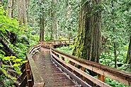
Mount Robson Provincial Park is a provincial park in the Canadian Rockies with an area of 2,249 km². The park is located entirely within British Columbia, bordering Jasper National Park in Alberta. The B.C. legislature created the park in 1913, the same year as the first ascent of Mount Robson by a party led by Conrad Kain. It is the second oldest park in the provincial system. The park is named for Mount Robson, which has the highest point in the Canadian Rockies and is located entirely within the park.

Geography of British Columbia Overview of the geography of British Columbia

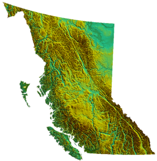
British Columbia is the westernmost province of Canada, bordered by the Pacific Ocean. With an area of 944,735 km2 (364,764 sq mi) it is Canada's third-largest province. The province is almost four times the size of the United Kingdom and larger than every United States state except Alaska and Texas. It is bounded on the northwest by the U.S. state of Alaska, directly north by Yukon and the Northwest Territories, on the east by Alberta, and on the south by the U.S. states of Washington, Idaho, and Montana. Formerly part of the British Empire, the southern border of British Columbia was established by the 1846 Oregon Treaty. The province is dominated by mountain ranges, among them the Canadian Rockies but dominantly the Coast Mountains, Cassiar Mountains, and the Columbia Mountains. Most of the population is concentrated on the Pacific coast, notably in the area of Vancouver, located on the southwestern tip of the mainland, which is known as the Lower Mainland. It is the most mountainous province of Canada.

Pacific Ranges

The Pacific Ranges are the southernmost subdivision of the Coast Mountains portion of the Pacific Cordillera. Located entirely within British Columbia, Canada, they run northwest from the lower stretches of the Fraser River to Bella Coola and Burke Channel, north of which are the Kitimat Ranges. The Coast Mountains lie between the Interior Plateau and the Coast of British Columbia.

Rainbow Range (Rocky Mountains) Subrange of the Park Ranges in Alberta and British Columbia, Canada

The Rainbow Range is a small subrange of the Park Ranges subdivisions of the Northern Continental Ranges of the Rocky Mountains on the border between Alberta and British Columbia in Mount Robson Provincial Park.

Mount Pope Provincial Park is a provincial park in British Columbia, Canada, located 7km northwest of Fort St. James in the Omineca Country region of that province's Central Interior. Mount Pope is about 1420 meters high and composed of limestone. The trail to the summit from Stones Bay Road gains about 700m and may be followed year-round. There are a few dozen developed rock climbs up to seven pitches long on the lower flanks of the mountain.

Mount Terry Fox Provincial Park is a provincial park in British Columbia, Canada. It is located in the Rocky Mountains near Mount Robson and the city of Valemount, British Columbia. The park and Mount Terry Fox, which is within the park, are named in honor of amputee long-distance runner and cancer research activist Terry Fox, a native of Winnipeg, Manitoba who grew up in British Columbia.

Purcell Wilderness Conservancy Provincial Park and Protected Area

The Purcell Wilderness Conservancy is a provincial park in British Columbia, Canada. It was established in 1974, and encompasses six large drainages in the Purcell Mountains in the southeast of the province. It contains high peaks, alpine meadows and ridges, deep creek and river valleys, and hot springs at Dewar Creek.

Tweedsmuir South Provincial Park is a provincial park covering parts of the eastern Kitimat Ranges, northern Pacific Ranges, and the Rainbow Range in British Columbia, Canada. It was established on May 21, 1938 to protect a vast area of pristine wilderness in the western interior of the province.

British Columbia Interior Interior region of British Columbia, Canada

The British Columbia Interior, popularly referred to as the BC Interior or simply the Interior, is a geographic region of the Canadian province of British Columbia. While the exact boundaries are variously defined, the British Columbia Interior is generally defined to include the 14 regional districts that do not have coastline along the Pacific Ocean or Salish Sea, and are not part of the Lower Mainland. Other boundaries may exclude parts of or even entire regional districts, or expand the definition to include the regional districts of Fraser Valley, Squamish–Lillooet, and Kitimat–Stikine.

The Northern Rocky Mountains, usually referred to as the Northern Rockies, are a subdivision of the Canadian Rockies comprising the northern half of the Canadian segment of the Rocky Mountains. While their northward limit is easily defined as the Liard River, which is the northward terminus of the whole Rockies, the southward limit is debatable, although the area of Mount Ovington and Monkman Pass is mentioned in some sources, as south from there are the Continental Ranges, which are the main spine of the Rockies forming the boundary between British Columbia and Alberta. Some use the term to mean only the area north of the Peace Arm of the Williston Reservoir, and in reference to Northern Rocky Mountains Provincial Park, while others consider the term to extend all the way south, beyond the limit of the Hart Ranges at Mount Ovington, to include the McBride area, the Sir Alexander Group and Mount Robson.

Montane Cordillera Ecozone in south-central British Columbia

The Montane Cordillera Ecozone, as defined by the Commission for Environmental Cooperation (CEC), is an ecozone in south-central British Columbia and southwestern Alberta, Canada. A rugged and mountainous ecozone spanning 473,000 square kilometres, it still contains "two of the few significant agricultural areas of the province", the Creston Valley and the Okanagan Valley. Primarily a mountainous region, it consists of rugged ecosystems such as alpine tundra, dry sagebrush and dense conifer forests. The interior plains are encircled by a ring of mountains. The area has a mild climate throughout the year, with typically dry summers and wet winters.

Robson Glacier

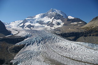
The Robson Glacier is the primary source of the short Robson River, one of the uppermost tributaries of the Fraser River. Located on the British Columbia-Alberta Boundary and the Continental Divide to the east of Berg Lake in Mount Robson Provincial Park, it sits on the northeast flank of Mount Robson in Mount Robson Provincial Park, British Columbia in the Canadian Rockies. Its meltwater feeds unofficially named Robson Lake, whose outlet marks the start of the Robson River.

Prince George-Valemount Provincial electoral district in British Columbia, Canada

Prince George-Valemount is a provincial electoral district in British Columbia, Canada, established by the Electoral Districts Act, 2008 out of most of Prince George-Mount Robson and small parts of Prince George North, Prince George-Omineca and Cariboo North. It was first contested in the 2009 provincial election.

Mount Gunanoot is a mountain in the Spatsizi Plateau of the North-Central Interior of British Columbia, Canada, located just east of the headwaters of the Spatsizi River. It is named for Simon Gunanoot, a Gitxsan packer, entrepreneur and erstwhile fugitive who was hunted for several years before turning himself in for trial and being acquitted. Gunanoot is responsible for "opening up" most of the country in this region.

Birkenhead Peak, commonly known as Mount Birkenhead and sometimes Birkenhead Mountain and also Mount Birken, 2506 m (8222 ft) prominence: 1781 m, is a mountain in the Gates Valley region of the Lillooet Country of the South-Central Interior of British Columbia, Canada. Located approximately midway between the towns of Lillooet (NE) and Pemberton-Mount Currie, the mountain's very high prominence separates it from the adjoining Cadwallader Range by the pass between Blackwater Creek and Birkenhead Lake.

References

  1. "B.C.'s most popular parks might surprise you". CBC. 2019-06-28. Retrieved 2020-08-27.
Map all coordinates using: OpenStreetMap  
Download coordinates as: KML

Commons-logo.svg Media related to Provincial Parks of British Columbia at Wikimedia Commons