Babine Lake Marine Park is on Babine Lake, which borders the Skeena and Omineca regions of central British Columbia. This provincial park comprises six separate sites around the lake. Vehicle access to the lake, via BC Highway 16 and Nilkitkwa forestry service road, is by road about 105 kilometres (65 mi) northeast of Smithers; via BC Highway 16 and Central Babine Lake Highway, is about 132 kilometres (82 mi) east of Smithers; or via Babine Lake Road, is about 20 kilometres (12 mi) northeast of Burns Lake.

Sasquatch Provincial Park is a provincial park in Kent, British Columbia, Canada.
Ethel F. Wilson Memorial Provincial Park is a provincial park in central British Columbia, Canada. The park is situated on the northern tip of Pinkut Lake. Activities in the park include rainbow trout fishing and boating. The park has five campsites that are allocated on a first-come first-served basis. The area of the park is 33 hectares.
Finger-Tatuk Provincial Park is a provincial park in British Columbia, Canada. Established in 1999, it covers 17,151 hectares and includes Finger Lake and Tatuk Lake, as well as several smaller lakes and archaeological sites once used by Dakelh (Carrier) First Nations peoples. The lakes are known for rainbow trout and kokanee salmon, and each of the two larger lakes has a resort.
Gladstone Provincial Park is a provincial park in British Columbia, Canada, surrounding and north of the north end of Christina Lake in that province's Boundary Country.
Goat Range Provincial Park is a provincial park in British Columbia, Canada.
Itcha Ilgachuz Provincial Park is a provincial park in the Chilcotin Country of British Columbia, Canada. The park is 111,977 hectares in size and contains Far Mountain and Mount Downton, its two most prominent peaks.
Jewel Lake Provincial Park is a provincial park bordering the northwestern end of Jewel Lake in the Boundary region of south central British Columbia. The park, via BC Highway 3 and Jewel Lake Rd, is about 14 kilometres (8.7 mi) northeast of Greenwood and 48 kilometres (30 mi) northwest of Grand Forks
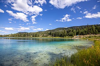
Kentucky Alleyne Provincial Park is a provincial park in British Columbia. The park is located 38 kilometres south of the city of Merritt, and east of the community of Aspen Grove. The park is named for two of its largest lakes, Kentucky Lake and Alleyne Lake. All lakes in the park have a distinctive turquoise colouration.
Kikomun Creek Provincial Park is a provincial park in British Columbia, Canada.

Lockhart Beach Provincial Park is a provincial park Located 40 km north of Creston, British Columbia, Canada, on BC Highway 3A. "This park and the adjacent Lockhart Creek Provincial Park extend 3 hectares, from the sunny shores of Kootenay Lake to the headwaters of Lockhart Creek. "This small park provides the only easy access to public camping along the south arm of Kootenay Lake. An 18-site campground and day-use area are located near a sand and fine gravel beach."
Tłu Tue - Maxhamish Lake Provincial Park and Protected Area is a 27,516-hectare (67,990-acre) provincial park in British Columbia, Canada.
Norbury Lake Provincial Park is a 97-hectare (240-acre) provincial park in British Columbia, Canada.

Summit Lake Provincial Park is a Class C provincial park located southeast of the community of Summit Lake in the Central Kootenay region of British Columbia, Canada.
Tudyah Lake Provincial Park is a provincial park in British Columbia, Canada. The park is approximately 56 km south of Mackenzie, BC on Highway 97.
Tweedsmuir South Provincial Park is a provincial park covering parts of the eastern Kitimat Ranges, northern Pacific Ranges, and the Rainbow Range in British Columbia, Canada. It was established on May 21, 1938 in the western interior of the province, to protect its important natural features. The park hosts a variety of recreation activities for visitors. This park encompasses a range of diverse species in this park including bears, moose, and various fish. There are also a few at risk species in this park.

Lac Le Jeune is a lake and provincial park in British Columbia, Canada, located approximately 37 kilometres south of Kamloops and 47 kilometres north of Merritt.

Canim Lake is a lake in British Columbia, Canada. Its west end is 36 km (22.4 mi) northeast of 100 Mile House. "Canim" means a type of large canoe in the Chinook Jargon. Canim Lake is 26.5 km (16.5 mi) long. It is also part of the territory of the Shuswap First Nation where the ancestors are part of the Lake Division of the Shuswap nation of the Interior Nations of British Columbia. The Reilly Commission states that the 2,029 hectares region around Canim Lake are set aside for the Shuswap First Nation. In the summer of 1995, there was an archaeological evidence of an ancient civilization and evidence of carbon dated as 4,300 old.

Mabel Lake is a lake located in southern Interior British Columbia, Canada, that is fed by and drained by the Shuswap River. It is located southeast of Shuswap Lake, northeast of Okanagan Lake, and west of the Monashee Mountains, and is popular for camping and fishing. The area around the lake is mountainous and sparsely populated.
Deka Lake is a freshwater body of water located in the Cariboo region of British Columbia. It is located in the Interlakes area. The lake holds two islands, one of which is privately owned. The name also applies to the surrounding rural community. The name comes from a misspelling of the name Decker, which was the name of a family from the Canim Lake Indian Band.