
Dawson Creek is a city in northeastern British Columbia, Canada. The municipality of 24.37 square kilometres (9.41 sq mi) had a population of 12,978 in 2016. Dawson Creek derives its name from the creek of the same name that runs through the community. The creek was named after George Mercer Dawson by a member of his land survey team when they passed through the area in August 1879. Once a small farming community, Dawson Creek became a regional centre after the western terminus of the Northern Alberta Railways was extended there in 1932. The community grew rapidly in 1942 as the US Army used the rail terminus as a transshipment point during construction of the Alaska Highway. In the 1950s, the city was connected to the interior of British Columbia via a highway and a railway through the Rocky Mountains. Since the 1960s, growth has slowed, but the area population has increased.

Hope is a district municipality at the confluence of the Fraser and Coquihalla rivers in the province of British Columbia, Canada. Hope is at the eastern end of both the Fraser Valley and the Lower Mainland region, and is at the southern end of the Fraser Canyon. To the east, over the Cascade Mountains, is the Interior region, beginning with the Similkameen Country on the farther side of the Allison Pass in Manning Park. Located 154 kilometres (96 mi) east of Vancouver, Hope is at the southern terminus of the Coquihalla Highway and the western terminus of the Crowsnest Highway, locally known as the Hope-Princeton, where they merge with the Trans-Canada Highway. Hope is at the eastern terminus of Highway 7. As it lies at the eastern end of the Fraser Valley in the windward Cascade foothills, the town gets very high amounts of rain and cloud cover – particularly throughout the autumn and winter.

The Thompson River is the largest tributary of the Fraser River, flowing through the south-central portion of British Columbia, Canada. The Thompson River has two main branches, the South Thompson River and the North Thompson River. The river is home to several varieties of Pacific salmon and trout. The area's geological history was heavily influenced by glaciation, and the several large glacial lakes have filled the river valley over the last 12,000 years. Archaeological evidence shows human habitation in the watershed dating back at least 8,300 years. The Thompson was named by Fraser River explorer, Simon Fraser, in honour of his friend, Columbia Basin explorer David Thompson. Recreational use of the river includes whitewater rafting and angling.

Lytton is a village of about 250 residents in southern British Columbia, Canada, on the east side of the Fraser River and primarily the south side of the Thompson River, where it flows southwesterly into the Fraser. The community includes the Village of Lytton and the surrounding community of the Lytton First Nation, whose name for the place is Camchin, also spelled Kumsheen.
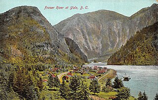
Yale is an unincorporated town in the Canadian province of British Columbia, which grew in importance during the Fraser Canyon Gold Rush.
Spuzzum is an unincorporated community in the lower Fraser Canyon area of southwestern British Columbia, Canada. The place is on the west shore of the Fraser River and north shore of Spuzzum Creek. The locality, on BC Highway 1, is by road about 40 kilometres (25 mi) north of Hope and 69 kilometres (43 mi) south of Lytton.

The Cariboo Road was a project initiated in 1860 by the Governor of the Colony of British Columbia, James Douglas. It was built in response to the Cariboo Gold Rush to facilitate settlement of the area by miners. It involved a feat of engineering stretching from Fort Yale to Barkerville, B.C. through extremely hazardous canyon territory in the Interior of British Columbia.

The Fraser Canyon is a major landform of the Fraser River where it descends rapidly through narrow rock gorges in the Coast Mountains en route from the Interior Plateau of British Columbia to the Fraser Valley. Colloquially, the term "Fraser Canyon" is often used to include the Thompson Canyon from Lytton to Ashcroft, since they form the same highway route which most people are familiar with, although it is actually reckoned to begin above Williams Lake at Soda Creek Canyon near the town of the same name.
Telegraph Creek is a small community located off Highway 37 in northern British Columbia at the confluence of the Stikine River and Telegraph Creek. The only permanent settlement on the Stikine River, it is home to approximately 250 members of Tahltan First Nation and non-native residents. The town offers basic services, including Anglican and Catholic churches, a general store, a post office, a clinic with several nurses on-call around the clock, two Royal Canadian Mounted Police officers, and a K-9 school. Steep river banks and rocky gorges form the terraced nature of the geography.

The Cariboo Gold Rush was a gold rush in the Colony of British Columbia, which later became the Canadian province of British Columbia. The first gold discovery was made at Hills Bar in 1858, followed by more strikes in 1859 on the Horsefly River, and on Keithley Creek and Antler Creek in 1860. The actual rush did not begin until 1861, when these discoveries were widely publicized. By 1865, following the strikes along Williams Creek, the rush was in full swing.
Seton Portage Historic Provincial Park is a historic provincial park located in the community of Seton Portage, British Columbia, Canada. It was established on March 29, 1972 to commemorate the location of the first railway in the province of British Columbia.

Tulameen, originally known as Otter Flat, is a small community in British Columbia, Canada, about 26 kilometres northwest of the town of Princeton on the Crowsnest Highway, and about 185 kilometres northeast from the city of Vancouver, British Columbia. Located at the south end of Otter Lake and just north of the Tulameen River, it is on the lee side of the Canadian Cascades mountain range and enjoys a slightly semi-arid climate, sheltered from the heavy rains west of that range.
Soda Creek is a rural subdivision 38 km north of Williams Lake in British Columbia, Canada. Located on the east bank of the Fraser River, Soda Creek was originally the home of the Xat'sull First Nation. Soda Creek Indian Reserve No. 1 is located on the left (E) bank of the Fraser River, one mile south of the Soda Creek BCR (CN) station, 431.10 ha. 52°19′00″N122°16′00″W

The Rock Creek Gold Rush was a gold rush in the Boundary Country region of the Colony of British Columbia. The rush was touched off in 1859 when two US soldiers were driven across the border to escape pursuing Indians and chanced on gold only three miles into British territory, on the banks of the Kettle River where it is met by Rock Creek, and both streams turn east to where in times since developed the city of Grand Forks. The first claim was filed by an Adam Beam in 1860, and the rush was on, composed mostly of Americans and some Chinese, all of whom had come overland from other workings, either at Colville or Oregon or all the way from California.
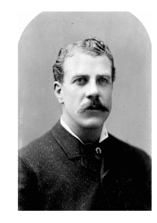
John Irving was a steamship captain in British Columbia, Canada. He began on the Fraser River at the age of 18 and would become one of the most famous and prosperous riverboat captains of the era. His father, William Irving, was known as the "King of the River" and the neighborhood of Irvington in Portland, Oregon, is named in honor of their family.

Bralorne is a historic Canadian gold mining community in the Bridge River District of British Columbia, some 130 km on dirt roads west of the town of Lillooet.
McGillivray, formerly McGillivray Falls, is an unincorporated recreational community on the west shore of Anderson Lake, just east of midway between the towns of Pemberton and Lillooet, British Columbia, Canada, in that province's southwest Interior.

Cottonwood, including the Cottonwood Ranch and Cottonwood House, is an unincorporated settlement in the North Cariboo region of the Central Interior of British Columbia, Canada. Originally a ranch, it is located in the northern Cariboo Plateau, just 8 km northwest of Coldspring House, which is at the confluence of the Swift River and Lightning Creek, which is the beginning of the Cottonwood River. Lightning Creek was one of the more famous of the gold-bearing creeks of the Cariboo Gold Rush.
Emory City was a town on the Fraser River just 5 km south of Yale, British Columbia.
Gold Trails and Ghost Towns is a Canadian historical documentary show, created and produced by television station CHBC-TV in Kelowna, British Columbia for Canadian syndication and hosted by Mike Roberts with historian/storyteller Bill Barlee. The show was filmed in a studio which resembled an old trapper's cabin. Mike and Bill discussed prospectors and the history of British Columbia around 1900.


