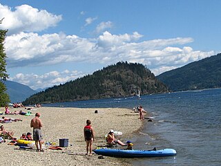
Adams Lake Provincial Park is a provincial park in British Columbia, Canada. It encompasses three distinct parks: Adams Lake Provincial Park, Adams Lake Marine Provincial Park, and Adams Lake Marine Provincial Park.
Conkle Lake Provincial Park is a provincial park in British Columbia, Canada, west of the confluence of the Kettle and West Kettle Rivers. The park size is 587 hectares. Bird species that live in the area are the common loon, merganser, ruffed grouse, pileated woodpecker, black-capped chickadee, and ruby-crowned kinglet. Mammals that live in the area are bears, squirrels, raccoons, rodents, beavers, deer, rabbits, foxes, and moose.

Darke Lake Provincial Park is a provincial park in British Columbia, Canada located west of Okanagan Lake, southwest of the town of Peachland in that province's Okanagan region. The park is approximately 1,470 hectares in size and was established in 1968 as a provincial park Darke Lake, also mapped historically as Fish Lake, is northwest of Summerland and is named after Silas Robert Darke, an early settler in the 1890s. In 1941 Howard Clark bought Fish Lake from Clyde Stewart. He was a hunting and fishing guide that ran the camp, as well as raised four children with his wife Hazel. The children were Betty, Roger, Dale & Audrey. In 1959 he sold it to Jake and Betty Enns.
Johnstone Creek Provincial Park is a provincial park in British Columbia, Canada, located west of the confluence of Rock Creek and the Kettle River and the town of Rock Creek. The park has a roughly 38 hectare area, and is near to the Crowsnest Highway.
Kootenay Lake Provincial Park is a provincial park in British Columbia, Canada. It encompasses five widely dispersed parks around Kootenay Lake: Kootenay Lake Provincial Park, Kootenay Lake Provincial Park, Kootenay Lake Provincial Park, Kootenay Lake Provincial Park, and Kootenay Lake Provincial Park.
Monte Creek Provincial Park is a provincial park in British Columbia, Canada, located in the locality of Monte Creek, British Columbia. Created in 1996, it is only 3 hectares in size, and protects a forested riparian area and also quiggly hole ("kekuli") sites of the Shuswap people, which have been formally studied as an archaeological site. The location was also part of the route of the Hudson's Bay Brigade Trail to the Cariboo via Kamloops from what is now the United States, as was Monte Lake in the upper basin of the eponymous creek.
Monte Lake Provincial Park is a provincial park in British Columbia, Canada, located on the east side of Monte Lake and to the south of the community of Monte Lake, British Columbia which is at the north end of the lake. About five hectares in size, it protects an area of Ponderosa pine and grasslands.
Upper Violet Creek Provincial Park is a provincial park in British Columbia, Canada.
Pennask Lake Provincial Park is a provincial park in British Columbia, Canada, located on the easternmost heights of the Thompson Plateau, 50 km (31 mi) to the northwest of the Okanagan town of Peachland.
Puntchesakut Lake Provincial Park is a provincial park in British Columbia, Canada. It is approximately 16.7m deep and has trout as the main fish source.

Shuswap Lake Provincial Park is a provincial park in British Columbia, Canada.
Syringa Park is a provincial park on the east shore of Lower Arrow Lake in the West Kootenay region of southeastern British Columbia. At the foot of the Norns Range, Tulip Creek passes through the centre, and Syringa Creek is closer to the southeastern boundary. The park is about 19 kilometres (12 mi) west of Castlegar via Broadwater Rd.
Taylor Arm Provincial Park is a provincial park in British Columbia, Canada, located on the north side of Sproat Lake 23 km northwest of Port Alberni on Vancouver Island. Situated along Highway 4, the 71-hectare park has few services but provides group camping sites, undeveloped beaches, and day-use areas. The group camping site has pit toilets and a hand pump water supply, and is connected to the lake shore via a trail that passes under the highway.
There are several lakes named Mud Lake within the Canadian province of Alberta.
The Lower Similkameen Indian Band or Lower Smelqmix, is a First Nations band government in the Canadian province of British Columbia. Their office was in the village of Keremeos in the Similkameen region, until 2015 when they moved into their own $7million multi-purpose facility south of Cawston. They are a member of the Okanagan Nation Alliance.
The Nation Lakes are a series of four lakes in the Nation River system of the Omineca Country of the Central Interior of British Columbia, Canada. The four lakes are, from west to east (downstream), Tsayta, Indata, Tchentlo, and Chuchi Lakes. Nation Lakes Park was established in 2004 as a result of the Fort St. James Land Resource Management Plan and is a popular canoeing destination.
The Cascade Recreation Area was a Provincial Recreation Area in the Hozameen Range of the Cascade Mountains of British Columbia, Canada, located north of and was added to E.C. Manning Provincial Park in 2010. It is roughly 11,858 ha. and was created on March 14, 1987. The recreation area has limited road access and is used by hikers, horse riders, mountain bikers and, in winter, snowmobilers. The nearest towns are Hope and Princeton.
The Sq'éwlets First Nation (Scowlitz) is the band government of Skaulits subgroup of the Stó:lō people located on Harrison Bay in the Upper Fraser Valley region between Chehalis (E) and Lake Errock, British Columbia, Canada (W). They are a member government of the Stó:lō Tribal Council.
Lambly Creek, also known as Bear Creek, is located in the Okanagan region of British Columbia. The creek flows into Okanagan Lake from the west, across from Kelowna. The canyon and mouth of the creek are protected by Bear Creek Provincial Park.
There are many lakes named Long Lake in British Columbia, Canada.


