
Fish Creek Park is an urban provincial park that preserves the valley of Fish Creek in the southern part of Calgary, Alberta, Canada. It is bordered on three sides by the city, and on the west by the territory of the Tsuu T’ina Nation (Sarcee), a First Nation.

Saskatoon Meewasin is a provincial electoral district for the Legislative Assembly of Saskatchewan, Canada. The district includes the neighbourhoods of River Heights, Richmond Heights, City Park, North Park, and Kelsey-Woodlawn.
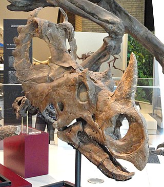
Centrosaurus is a genus of centrosaurine ceratopsian dinosaur from Campanian age of Late Cretaceous Canada. Their remains have been found in the Dinosaur Park Formation, dating from 76.5 to 75.5 million years ago.

A provincial park is a park administered by one of the provinces of a country, as opposed to a national park. They are similar to state parks in other countries. They are typically open to the public for recreation. Their environment may be more or less strictly protected.

Red Lodge Provincial Park is a provincial park located in Alberta, Canada. The park is approximately 14 kilometres (8.7 mi) west of the town of Bowden. It is located on the north side of Alberta Highway 587 with the Little Red Deer River flowing directly through it.
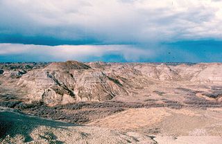
The Dinosaur Park Formation is the uppermost member of the Belly River Group, a major geologic unit in southern Alberta. It was deposited during the Campanian stage of the Late Cretaceous, between about 76.5 and 74.4 million years ago. It was deposited in alluvial and coastal plain environments, and it is bounded by the nonmarine Oldman Formation below it and the marine Bearpaw Formation above it.
The Wellington Rugby League Team are a rugby league team that represents the Wellington Rugby League in New Zealand Rugby League competitions. They currently compete in the National Competition.
Declan Ryan is an Irish former hurler and team manager with Tipperary.
The 1983 All-Ireland Senior Hurling Championship was the 97th staging of the All-Ireland Senior Hurling Championship, the Gaelic Athletic Association's premier inter-county hurling tournament. The draw for the 1980 fixtures took place in September 1979. The championship began on 29 May 1983 and ended on 4 September 1983.
Timothy Ryan was an Irish hurler who played as a midfielder at senior level for the Limerick county team.
The All-Ireland Senior Hurling Championship of 1967 was the 81st staging of Ireland's premier hurling knock-out competition. Kilkenny won the championship, beating Tipperary 3-8 to 2-7 in the final at Croke Park, Dublin.
The All-Ireland Senior Hurling Championship of 1985 was the 99th edition of Ireland's premier hurling knockout competition. The championship ran from May to September of that year, culminating with the All-Ireland final, held at Croke Park, Dublin on 1 September. The match was contested by Offaly and Galway, with Offaly taking the title by 2–11 to 1–12. It was Offaly's second-ever All-Ireland title.
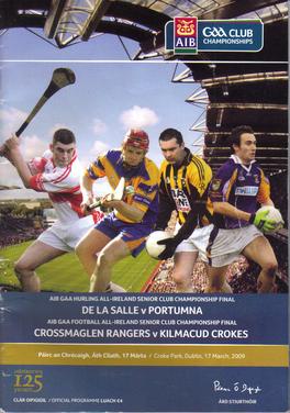
The 2008–09 All-Ireland Senior Club Hurling Championship was the 39th since the establishment of the competition by the Gaelic Athletic Association in 1970–71. The first matches of the season were played on 12 October 2008 and the championship ended on 17 March 2009. Portumna went into the 2008 championship as defending champions, having won their second All-Ireland title the previous year.

The 2012 All-Ireland Senior Hurling Championship was the 125th staging of the All-Ireland hurling championship since its establishment by the Gaelic Athletic Association in 1887. The draw for the 2012 fixtures took place on 6 October 2011. The championship began on 19 May 2012 and ended on 30 September 2012.
Unescoceratops is a genus of leptoceratopsid ceratopsian dinosaurs known from the Late Cretaceous of Alberta, southern Canada. It contains a single species, Unescoceratops koppelhusae.
The Provincial Archive are a Canadian indie band. Their releases have spanned genres from indie folk to alt rock. Their music has been compared to R.E.M. and The Shins as well as early Weezer and Elliott Smith.
The 2016 All-Ireland Senior Football Championship was the 129th edition of the GAA's premier inter-county gaelic football tournament since its establishment in 1887.
Nicole Sarauer is a Canadian politician, who was elected to the Legislative Assembly of Saskatchewan in the 2016 provincial election. She represents the electoral district of Regina Douglas Park as a member of the Saskatchewan New Democratic Party. On June 20, 2017, she was selected to succeed Trent Wotherspoon as Leader of the Opposition and interim leader of the Saskatchewan New Democratic Party.
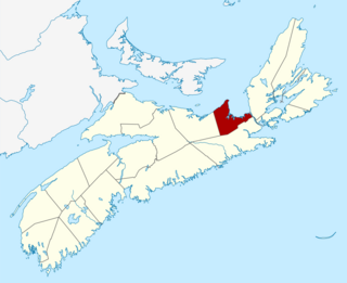
Antigonish County is a historical county and census division of Nova Scotia, Canada. Local government is provided by the Municipality of the County of Antigonish, the Town of Antigonish, and by two reserves: Pomquet and Afton 23, and Summerside 38.
Candle Lake Provincial Park is a provincial park in the central region of the Canadian province of Saskatchewan. Prior to the park's establishment in 1986, it was a provincial recreation site. Located in the Rural Municipality of Paddockwood No. 520, Candle Lake Provincial Park surrounds most of Candle and Torch Lakes in the boreal forest ecozone of Canada. The park has a variety of activities including camping, boating, fishing, swimming, mini golfing, hiking, and golfing. Around the lake there are also boat launches and several marinas. Natural attractions include a purple sand beach, sand dunes, mature forests, crystal clear lake water, and several natural sand beaches.

