
Desolation Sound is a deep water sound at the northern end of the Salish Sea and of the Sunshine Coast in British Columbia, Canada.

Adams Lake Provincial Park is a provincial park in British Columbia, Canada. It encompasses three distinct parks: Adams Lake Provincial Park, Adams Lake Marine Provincial Park, and Adams Lake Marine Provincial Park.
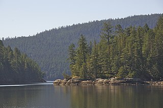
Clayoquot Arm Provincial Park is a provincial park in British Columbia, Canada.
Clayoquot Plateau Provincial Park is a provincial park in British Columbia, Canada. It is located on the west side of the Kennedy River, to the northeast of the town of Tofino.
Desolation Sound Marine Provincial Park is a provincial park in British Columbia, Canada located along Desolation Sound. The park is distinguished by its many picturesque sheltered coves and anchorages, frequented by yachts and pleasure craft. The scenery consists of waterfalls, rugged glaciated peaks, and steep forested slopes that fall into the ocean.

Herald Provincial Park is a provincial park in British Columbia, Canada. It is on the north shore of the Salmon Arm of Shuswap Lake, in the Southern Interior of British Columbia, Canada. The park is some 30 minutes northeast of the city of Salmon Arm. Herald Park contains a popular camping area, as well as a day use/picnic area. Large pebble beaches stretch along the southern boundary of the park. Walking and hiking trails exist throughout the park, including an easy 10-minute hike to the spectacular Margaret Falls.

Say Nuth Khaw Yum Provincial Park, also known as Indian Arm Provincial Park, is a provincial park located in the Lower Mainland of British Columbia, Canada. The park was established on July 13, 1995 by BC Parks to protect the forested mountain terrain of Indian Arm.

Lockhart Beach Provincial Park is a provincial park Located 40 km north of Creston, British Columbia, Canada, on BC Highway 3A. "This park and the adjacent Lockhart Creek Provincial Park extend 3 hectares, from the sunny shores of Kootenay Lake to the headwaters of Lockhart Creek. "This small park provides the only easy access to public camping along the south arm of Kootenay Lake. An 18-site campground and day-use area are located near a sand and fine gravel beach."
Upper Seymour River Provincial Park is a provincial park in British Columbia, Canada. Located in an isolated area in the interior of the province, 40 kilometres north of the community of Seymour Arm. It protects at the headwaters of the Seymour River, which is the major drainage system into the Seymour Arm of Shuswap Lake.

Shuswap Lake Provincial Park is a provincial park in British Columbia, Canada.
Sunnybrae Provincial Park is a provincial park in British Columbia, Canada, located on the northern side of the Salmon Arm of Shuswap Lake, near the city of Salmon Arm. Sunnybrae is a day use park with washrooms, picnic tables, playground and swimming area.
Taylor Arm Provincial Park is a provincial park in British Columbia, Canada, located on the north side of Sproat Lake 23 km northwest of Port Alberni on Vancouver Island. Situated along Highway 4, the 71-hectare park has few services but provides group camping sites, undeveloped beaches, and day-use areas. The group camping site has pit toilets and a hand pump water supply, and is connected to the lake shore via a trail that passes under the highway.
Teakerne Arm Provincial Park is a provincial park in British Columbia, Canada, located on the north shore of Teakerne Arm on West Redonda Island in the Discovery Islands archipelago, to the northeast of the city of Campbell River, Canada.
Indian Arm is a steep-sided glacial fjord adjacent to the city of Vancouver in southwestern British Columbia. Formed during the last Ice Age, it extends due north from Burrard Inlet, between the communities of Belcarra and the District of North Vancouver, then on into mountainous wilderness. Burrard Inlet and the opening of Indian Arm was mapped by Captain George Vancouver and fully explored days later by Dionisio Alcalá Galiano in June 1792.

Lund is a small craft harbour and unincorporated village on Tla'amin land in qathet Regional District, British Columbia, Canada. It is along the northern part of the Salish Sea on the mainland BC coast. The main landmark in the village is the Lund Hotel, established in 1905. By boat from Lund, the Copeland Islands and Desolation Sound, are nearby. Lund is home to many shops and services including a general store, a restaurant overlooking the water, kayak and adventure tourism stores, and Nancy's Bakery, a favourite of locals and tourists.
Eagle Mountain, also known as Eagle Ridge, is the mountainous ridge with many indistinct summits between Buntzen Lake and Coquitlam Lake near Coquitlam, British Columbia. Its proximity to Coquitlam, and the houses being built on its southern slopes, make it a very popular weekend destination for hiking, mountain biking, horseback riding, and ATV riding. There is a network of logging roads leading up the south side of the summit to a plateau area with lakes, hiking trails and mountain biking trails.
Oregana Creek Provincial Park is a provincial park in British Columbia, Canada, located 150 kilometres northwest of Salmon Arm, British Columbia, near Adams River. The park, which is 286 ha. in size, was established in 2010.
Malaspina Inlet is an inlet on the east side of Desolation Sound in the South Coast region of British Columbia, Canada, located between Malaspina and Gifford Peninsulas. Sidewaters include Thors Cove and, via it, Theodosia Inlet, where the locality of Theodosia Arm is located. The upper, southeastern, end of Malaspina Inlet near the City of Powell River is called Okeover Inlet. on the east side of which the steamer landing Larsons Landing is located. Grace Harbour is located on north side of Malaspina Inlet on the southwest side of Gifford Peninsula.
Okeover Inlet, formerly Okeover Arm, is an inlet in the Sunshine Coast region of the southwestern mainland of British Columbia, Canada. It is the upper end of Malaspina Inlet and is northwest of the City of Powell River. Larsons Landing, a steamer landing, is located on its eastern shore.
Okeover is an English surname. It may refer to:


