Related Research Articles

Princess Royal Island is the largest island on the North Coast of British Columbia, Canada. It is located amongst the isolated inlets and islands east of Hecate Strait on the British Columbia Coast. At 2,251 square kilometres (869 sq mi), it is the fourth largest island in British Columbia. It was named in 1788 by Captain Charles Duncan, after his ship Princess Royal.
Bishop River Provincial Park is a provincial park in the Pacific Ranges of the Coast Mountains on the Mainland of British Columbia, Canada, located southwest of and adjoining Ts'yl-os Provincial Park."Bishop River Park". BC Geographical Names. It lies along the upper course of the Bishop River, the main tributary of the Southgate River, from the Bishop's source at the western side of the Lillooet Icecap to midway along its course above its confluence with the Southgate. The park is 19,947 ha. in size. There are no roads or trails in the park although a forest service road from Waddington Harbour at the head of Bute Inlet leads up the Southgate to within a few miles of the park boundary.
Okeover Arm Provincial Park is a provincial park in British Columbia, Canada, located on the west side of Okeover Inlet facing Desolation Sound, on the east side of the Malaspina Peninsula.

The Gwa'Sala-Nakwaxda'xw Nations are a union of two Kwakwaka'wakw peoples in a band government based on northern Vancouver Island in British Columbia, Canada, whose main reserve community is near the town of Port Hardy in the Queen Charlotte Strait region of the Central Coast region of British Columbia, Canada. The band government is a member of the Kwakiutl District Council and, for treaty negotiation purposes, the Winalagalis Treaty Group which includes three other members of the Kwakiutl District Council.
The Tlowitsis Nation, formerly the Klowitsis Tribe, the Turnour Island Band and the Tlowitsis-Mumtagila First Nation, is the Indian Act band government of the Ławit'sis (Tlowitsis) tribe of the Kwakwaka'wakw peoples, located in the Queen Charlotte Strait-Johnstone Strait area in the Discovery Islands between Vancouver Island and the British Columbia mainland in Canada. Ławit'sis territory covers parts of northern Vancouver Island, Johnstone Strait, and adjoining inlets of the mainland. Kalugwis, on Turnour Island, was their principal community in times past, but the band's offices are in the city of Campbell River to the southeast. Hanatsa IR No. 6 on Port Neville is the most populated of the band's Indian reserves.
Kilbella Bay is a bay on the Central Coast of British Columbia, Canada, off the north side of Rivers Inlet to the northeast of McAllister Point. A steamer landing formerly operated by the Northland Navigation Company was located on the east side of the bay.
Theodosia Inlet is an inlet in the Desolation Sound region of the South Coast region of British Columbia, Canada, located east of Lancelot Inlet, a sub-inlet of Malaspina Inlet. The inlet is fed by the Theodosia River. The locality of Theodosia Arm is located near its outlet at the head of Thors Cove.
Theodosia Arm is a locality in the Desolation Sound area of the South Coast region of British Columbia, Canada, located at the head of Thors Cove, an arm of Malaspina Inlet, near the outlet of Theodosia Inlet.
Malaspina Inlet is an inlet on the east side of Desolation Sound in the South Coast region of British Columbia, Canada, located between Malaspina and Gifford Peninsulas. Sidewaters include Thors Cove and, via it, Theodosia Inlet, where the locality of Theodosia Arm is located. The upper, southeastern, end of Malaspina Inlet near the City of Powell River is called Okeover Inlet. on the east side of which the steamer landing Larsons Landing is located. Grace Harbour is located on north side of Malaspina Inlet on the southwest side of Gifford Peninsula.
The Gifford Peninsula is a peninsula on the east side of Desolation Sound in the Sunshine Coast region of the South Coast of British Columbia, Canada, located immediately north of the Malaspina Peninsula and separated from it by Malaspina Inlet. On its east side is Lancelot Inlet and its arm Theodosia Inlet
Lancelot Inlet is an inlet in the Sunshine Coast region of the South Coast of British Columbia, Canada. It is a sidewater of Malaspina Inlet, and immediately east of the Gifford Peninsula. Via Thors Cove on its east side, its own sidewater is Theodosia Inlet, at the head of which is the mouth of the Theodosia River. The locality of Theodosia Arm is located here.
Larsons Landing is a steamer landing on the northwest shore of Okeover Inlet, which is the upper end of Malaspina Inlet in the Sunshine Coast region of British Columbia, Canada.
Grace Harbour is a harbour and traditional village site of the Tla'amin peoples in the South Coast of British Columbia, located near Desolation Sound on the south side of the Gifford Peninsula opposite the Malaspina Peninsula to the southwest. Along with the Gifford Peninsula, it is part of Desolation Sound Marine Provincial Park. Kahkaykay Indian Reserve No. 6 was located on the west side of the harbour but as of 2011 is now fee-simple land as a result of the Sliammon Treaty. at 50°02′58″N124°45′21″W The headland at the southwest corner of the harbour is similarly named from the name of the ancient village at this site, Kakaekae Point, at 50°02′32″N124°45′56″W
The Coode Peninsula is a small peninsula on the inner side of the larger Malaspina Peninsula in the Sunshine Coast area of the South Coast of British Columbia, Canada, projecting into Malaspina Inlet just south of Okeover Inlet.

Port Neville is a bay, port and locality on the north side of Johnstone Strait, south of Call Inlet, in the Central Coast region of British Columbia, Canada.

East Cracroft Island is an island in the Johnstone Strait region of the Central Coast region of British Columbia, Canada. It is the smaller of the two Cracroft Islands, and at low tide is really one island with its larger neighbour, West Cracroft Island. On the south side of the shallows that form an isthmus between them at low tide is Port Harvey, a short, wide inlet or bay. On its east shore is Keecekiltum Indian Reserve No. 2, which is under the governance of the Tlowitsis Nation of the Kwakwaka'wakw peoples. at 50°33′00″N126°16′00″W.
Drury inlet is an inlet in the Queen Charlotte Strait region of the Central Coast of British Columbia, Canada, extending west from Wells Passage to the northwest of North Broughton Island, northwest of the town of Port Hardy. Branching off to the northeast from the north side of the head of the inlet is Actaeon Sound.
Waddington Harbour is a harbour at the head of Bute Inlet in the Central Coast region of British Columbia, Canada. Also issuing into the head of Bute Inlet and Waddington Harbour, just east of the mouth of the Homathko, is the Teaquahan River. Issuing directly into the inlet a few miles south on the harbour's southeast is the Southgate River, one of the major rivers of the central Pacific Ranges, which begins on the west side of the Lillooet Icecap. Its lower valley adjacent to the inlet's shores is called Pigeon Valley.
The Teaquahan River, formerly Teaquahan Creek, is a river in the Pacific Ranges of the Coast Mountains, flowing into the head of Bute Inlet at Waddington Harbour, immediately east of the mouth of the Homathko River.
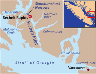
Narrows Inlet formerly Narrows Arm is a fjord branching east from Sechelt Inlet in British Columbia, Canada. Its companion, Salmon Inlet, another side-inlet of Sechelt Inlet, lies roughly 10 km (6.2 mi) south.
References
50°00′14″N124°42′40″W / 50.00389°N 124.71111°W
| | This article about a location on the South Coast of British Columbia, Canada is a stub. You can help Wikipedia by expanding it. |