
Archibald Philip Primrose, 5th Earl of Rosebery, 1st Earl of Midlothian, was a British Liberal Party politician who served as Prime Minister of the United Kingdom from March 1894 to June 1895. Between the death of his father, in 1851, and the death of his grandfather, the 4th Earl of Rosebery, in 1868, he was known by the courtesy title of Lord Dalmeny.

Earl of Rosebery is a title in the Peerage of Scotland created in 1703 for Archibald Primrose, 1st Viscount of Rosebery, with remainder to his issue male and female successively. Its name comes from Roseberry Topping, a hill near Archibald's wife's estates in Yorkshire. The current earl is Harry Primrose, 8th Earl of Rosebery.
Rosebery or Roseberry may refer to:

Dalmeny House is a Gothic revival mansion located in an estate close to Dalmeny on the Firth of Forth, in the north-west of Edinburgh, Scotland. It was designed by William Wilkins, and completed in 1817. Dalmeny House is the home of the Earl and Countess of Rosebery. The house was the first in Scotland to be built in the Tudor Revival style. It provided more comfortable accommodation than the former ancestral residence, Barnbougle Castle, which still stands close by. Dalmeny today remains a private house, although it is open to the public during the summer months. The house is protected as a category A listed building, while the grounds are included in the Inventory of Gardens and Designed Landscapes in Scotland.
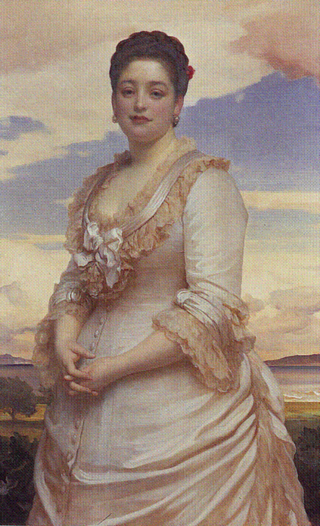
Hannah Primrose, Countess of Rosebery was the daughter of Baron Mayer de Rothschild and his wife Juliana. After inheriting her father's fortune in 1874, she became the richest woman in Britain. In 1878, Hannah de Rothschild married Archibald Primrose, 5th Earl of Rosebery, and was thereafter known as the Countess of Rosebery.
Rosebery is a town on the west coast of Tasmania, Australia. It is at the northern end of the West Coast Range, in the shadow of Mount Black and adjacent to the Pieman River, now Lake Pieman.
Neil Archibald Primrose, 7th Earl of Rosebery, 3rd Earl of Midlothian, DL, styled Lord Primrose between 1931 and 1974, was a Scottish nobleman. He was a member of the House of Lords from 1974 to 1999. He was succeeded by his son Harry Primrose, Lord Dalmeny.

Rosebery is an inner southern suburb of Sydney, in the state of New South Wales, Australia. It is 6 kilometres south of the Sydney central business district and is part of the local government areas of the City of Sydney and the Bayside Council.
The Champagne Stakes is an American Grade I Thoroughbred horse race for two-year-old horses. The race is run at a distance of one mile on the dirt at Belmont Park in October each year. Although the race is open to both colts and fillies, in practice it is New York's premier race for two-year-old colts and fillies enter the Frizette Stakes instead.

Mansa is the capital of the Luapula Province of Zambia, and headquarters of Mansa District. It takes its name from the local Chief Mansa and the small Mansa River which flows west to the Luapula River. During British rule the city was named Fort Rosebery.

Dulwich Park is a 30.85-hectare (76.2-acre) public park in Dulwich in the London Borough of Southwark, south London, England. The park was created by the Metropolitan Board of Works from former farmland and meadows. While the initial design was by Charles Barry (junior), it was later refined by Lt Col JJ Sexby. It was opened in 1890 by Lord Rosebery. From 2004 to 2006, the park was restored to its original Victorian layout, following a grant from the Heritage Lottery Fund. The park is listed Grade II on the Register of Historic Parks and Gardens.

Blue Peter (1936–1957) was a British bred Thoroughbred racehorse whose career was cut short by the outbreak of World War II. He won The Derby and was later a Leading broodmare sire in Great Britain & Ireland.
The Rosebery Charity Cup was a football competition organised for senior clubs from the East of Scotland.
The Slocan Valley is a valley in the West Kootenay region of southeastern British Columbia.
Rosebery School is an all-girls school located in Epsom, Surrey. It consists of a lower school for those aged between 11 and 16, and a sixth form for those aged between 16 and 18. The school has academy status. It is situated close to the A24, and is a 10 to 20-minute walk from Epsom town centre and Epsom railway station.

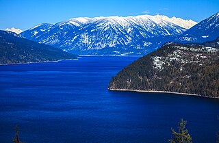
Slocan Lake is a lake in the Slocan Valley of the West Kootenay region of the Southeastern Interior of British Columbia, Canada. With an area of 69.29 km2 (26.75 sq mi) it has a maximum depth of 298 m (978 ft). It is fed by Bonanza Creek and drained by the Slocan River.
Shawfield Football Club was a Scottish football team that competed in the Junior set-up and won the Scottish Junior Cup in 1946–47. There are also a number of references to them being called Shawfield Juniors.
Rosebery Park was a football ground in the Oatlands area of Glasgow, Scotland. It was the home of Shawfield F.C. from 1918 to 1960, before being acquired by Glasgow Corporation as a venue for schools' football matches. The discovery that the site was contaminated led to the ground becoming derelict in the 1990s, and it was subsequently demolished.

Williamsford, Tasmania is the location of a former mining community, south of Rosebery, Tasmania and on the western lower reaches of Mount Read.

Ladas (1891–1914) was a British Thoroughbred racehorse and sire. His career attracted an unusual amount of attention as his owner, Lord Rosebery, became Prime Minister of the United Kingdom at the height of his success.

