
Vancouver Island is an island in the northeastern Pacific Ocean and part of the Canadian province of British Columbia. The island is 456 km (283 mi) in length, 100 km (62 mi) in width at its widest point, and 32,100 km2 (12,400 sq mi) in total area, while 31,285 km2 (12,079 sq mi) are of land. The island is the largest by area and the most populous along the west coasts of the Americas.

The following is an alphabetical list of articles related to the Canadian province of British Columbia.

Quatsino Provincial Park is a provincial park in British Columbia, Canada, located on Quatsino Sound on northern Vancouver Island. The park was established July 12, 1995 and is 654 hectares in size. The park is 50 kilometres (31 mi) west of Port Hardy, British Columbia and is accessible by rough logging roads or by boat. Quatsino is on a popular kayaking route.
Claud Elliott Provincial Park is a provincial park in British Columbia, Canada located on northern Vancouver Island approximately 50 kilometres (31 mi) southeast of Port McNeill, between the Tsitsika River and Bonanza Lake, near the community of Woss.

Davis Lake Provincial Park is a 185 acres (0.75 km2) park in British Columbia, Canada, established as a protected provincial park in October 1963. It is located east of the southern end of Stave Lake, northeast of Mission, British Columbia, approximately 18 km north on Sylvester Rd from BC Highway 7. There are campgrounds and beaches at the south end of the lake, access is walk-in only via a 1 km unmaintained gravel road.

Fossli Provincial Park is a provincial park in British Columbia, Canada, located on Stirling Arm of Sproat Lake on Vancouver Island. The 52-hectare park, west of Port Alberni, is accessible by water or private logging road. It has few services, but has a 30-minute hiking trail to an old homestead site. The homestead belonged to Helen and Armour Ford, who donated the land for the park to the province in 1974. Saint Andrew's Creek runs through the park, and is a fall spawning ground for coho salmon.
Lower Nimpkish Provincial Park is a provincial park in British Columbia, Canada, located on the lower Nimpkish River. It is an undeveloped wilderness park that seeks to preserve the habitat while offering fishing and nature appreciation opportunities to the public.
Memory Island Provincial Park is a provincial park located on Vancouver Island in British Columbia, Canada. It was established by BC Parks on 23 August 1945 to protect a small island located at the southern end of Shawnigan Lake.
Morton Lake Provincial Park is a provincial park in British Columbia, Canada, located on Vancouver Island northwest of the city of Campbell River.
Nitinat River Provincial Park is a provincial park in the Canadian province of British Columbia on Vancouver Island.
Schoen Lake Provincial Park is a provincial park in northeastern Vancouver Island, British Columbia, Canada, located east of the community of Woss Lake and southwest of Sayward. The park lies inside the Nimpkish Valley watershed. On October 28, 1977, the "Class A" park was officially created to protect, exhibit and interpret an example of the natural features and processes of the Insular Mountains Natural Region. The park covers a total area of 8,775 hectares. Within those hectares of park land is a number of lakes, creeks and mountain ranges.

Buttle Lake is a lake on Vancouver Island in Strathcona Regional District, British Columbia, Canada. It is about 23 kilometres (14 mi) long and 1.5 kilometres (0.9 mi) wide, has an area of 28 square kilometres (11 sq mi), is up to 120 metres (394 ft) deep, and lies at an elevation of 221 metres (725 ft). The lake is located between Campbell River and Gold River in Strathcona Provincial Park. The lake is the headwaters of the Campbell River.
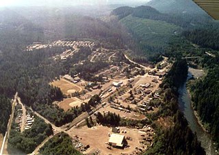
Woss, also commonly known as Woss Lake after the nearby lake of the same name, is a small village in the Nimpkish Valley, located 75 km (47 mi) southeast of Port McNeill and 128 km (80 mi) north of Campbell River on Highway 19, in northeastern Vancouver Island, British Columbia, Canada. The estimated population of Woss and the Nimpkish Valley is 200. The town of Woss lies about 3 km north of Woss Lake, a long, narrow lake stretching about 10 km in a primarily north–south direction with a maximum width of about one km, the southern portion of which is part of Woss Lake Provincial Park.

The Vancouver Island Ranges, formerly called the Vancouver Island Mountains, are a series of mountain ranges extending along the length of Vancouver Island which has an area of 31,788 km2 (12,273 sq mi). The Vancouver Island Ranges comprise the central and largest part of the island. The Geological Survey of Canada refers to Vancouver Island, Haida Gwaii, and the Alaska Panhandle as the Insular Belt including the sea floor out to 100 km (62 mi) west of Vancouver Island. The Vancouver Island Ranges are a sub-range of the Insular Mountains.
The Insular Mountains are a range of mountains in the Pacific Coast Ranges on the Coast of British Columbia, Canada, comprising the Vancouver Island Ranges and Queen Charlotte Mountains. The Insular Mountains are rugged, particularly on Vancouver Island where peaks in Strathcona Provincial Park rise to elevations of more than 2,000 m (6,562 ft). The highest of these mountains is Golden Hinde on Vancouver Island, which rises to 2,196.818 m (7,207 ft).
The 'Namgis First Nation is a First Nations band government on northern Vancouver Island in British Columbia, Canada, and on adjoining islands in the southern Queen Charlotte Strait region.
Karmutzen Mountain is a mountain located in the Karmutzen Range on Vancouver Island in British Columbia. It is to the west of Nimpkish Lake which was formerly known as Karmutzen Lake.

The Nimpkish River is a river in northern Vancouver Island in British Columbia, Canada. It is the longest river on the Island, rising on the west slope of Mount Alston, flowing northwest into Nimpkish Lake and then north into the Broughton Strait at a point 8 km east of Port McNeill, just southwest of the town of Alert Bay on Cormorant Island.
Nimpkish Lake is a lake on in the Northern Vancouver Island region of British Columbia, Canada. It is the location of Nimpkish Lake Provincial Park and is 32 km south of Port McNeill. The lake is in the traditional territory of the Namgis First Nation, who are its namesake. It is part of the drainage basin of the Nimpkish River.


