
Pinecone Burke Provincial Park is a provincial park in British Columbia, Canada. It extends from the southwest corner of Garibaldi Provincial Park, west of Pitt Lake and Pitt River to include Burke Mountain in the City of Coquitlam. Most of the park is unserviced wilderness with very rough trails such as the Fools Gold Trail in the Boise Valley. There is canoe access to Widgeon Slough and from there hiking trails that lead to Widgeon Lake, and a network of old logging roads, hiking and mountain biking trails on Burke Mountain. Visitors can also use the park for camping, backcountry skiing, and snowshoeing.
Christina Lake Provincial Park is a provincial park in British Columbia, Canada. The lake it's on, Christina Lake, is renowned as the warmest lake in Canada.
Duffey Lake Provincial Park is a provincial park in British Columbia, Canada, located at the lake of the same name, which lies along BC Highway 99 just east of the summit of Cayoosh Pass. The lake's inflow and outflow are Cayoosh Creek. The park's highest point is Mount Rohr at the westernmost boundary.

Davis Lake Provincial Park is a 185 acres (0.75 km2) park in British Columbia, Canada, established as a protected provincial park in October 1963. It is located east of the southern end of Stave Lake, northeast of Mission, British Columbia, approximately 18 km north on Sylvester Rd from BC Highway 7. There are campgrounds and beaches at the south end of the lake, access is walk-in only via a 1 km unmaintained gravel road.
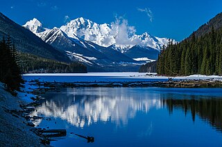
Kinaskan Lake Provincial Park is a provincial park in British Columbia, Canada, located at the south end of Kinaskan Lake along the Stewart-Cassiar Highway near Mowdade Lake and southeast of Mount Edziza. At the south end of the park, the Iskut River, of which the lake is an expansion, spills over 12.2-metre Cascade Falls. The park is approximately 800 ha. in size.
Lower Nimpkish Provincial Park is a provincial park in British Columbia, Canada, located on the lower Nimpkish River. It is an undeveloped wilderness park that seeks to preserve the habitat while offering fishing and nature appreciation opportunities to the public.
Monte Lake Provincial Park is a provincial park in British Columbia, Canada, located on the east side of Monte Lake and to the south of the community of Monte Lake, British Columbia which is at the north end of the lake. About five hectares in size, it protects an area of Ponderosa pine and grasslands.
Nimpkish Lake Provincial Park is a provincial park on northern Vancouver Island, British Columbia, Canada on Vancouver Island. The park is 3,949 ha. in area and was established on 1995. It is 32 km south of Port McNeill and on the southwest side of Nimpkish Lake. Primary access is by boat launch, though radio-controlled logging roads lead to the edge of the park. Western Forest Products in Woss, British Columbia should be contacted for road advisories. The park is in the traditional territory of the Namgis First Nation.
Schoen Lake Provincial Park is a provincial park in northeastern Vancouver Island, British Columbia, Canada, located east of the community of Woss Lake and southwest of Sayward. The park lies inside the Nimpkish Valley watershed. On October 28, 1977, the "Class A" park was officially created to protect, exhibit and interpret an example of the natural features and processes of the Insular Mountains Natural Region. The park covers a total area of 8,775 hectares. Within those hectares of park land is a number of lakes, creeks and mountain ranges.
Tweedsmuir North Provincial Park and Protected Area is a provincial park in British Columbia, Canada, which along with Tweedsmuir South Provincial Park and Entiako Provincial Park were once part of Tweedsmuir Provincial Park, then B. C.'s largest park, 9,810 square kilometres (3,790 sq mi) located in the Coast Range.
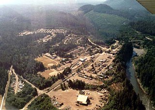
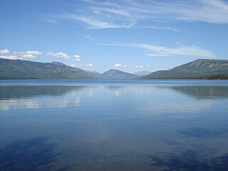
Woss, also commonly known as Woss Lake after the nearby lake of the same name, is a small village in the Nimpkish Valley, located 75 km (47 mi) southeast of Port McNeill and 128 km (80 mi) north of Campbell River on Highway 19, in northeastern Vancouver Island, British Columbia, Canada. The estimated population of Woss and the Nimpkish Valley is 200. The town of Woss lies about 3 km north of Woss Lake, a long, narrow lake stretching about 10 km in a primarily north-south direction with a maximum width of about one km, the southern portion of which is part of Woss Lake Provincial Park.

The Vancouver Island Ranges, formerly called the Vancouver Island Mountains, are a series of mountain ranges extending along the length of Vancouver Island which has an area of 31,788 km2 (12,273 sq mi). The Vancouver Island Ranges comprise the central and largest part of the island. The Geological Survey of Canada refers to Vancouver Island, Haida Gwaii, and the Alaska Panhandle as the Insular Belt including the sea floor out to 100 km (62 mi) west of Vancouver Island. The Vancouver Island Ranges are a sub-range of the Insular Mountains.
The Insular Mountains are a range of mountains in the Pacific Coast Ranges on the Coast of British Columbia, Canada, comprising the Vancouver Island Ranges and Queen Charlotte Mountains. The Insular Mountains are rugged, particularly on Vancouver Island where peaks in Strathcona Provincial Park rise to elevations of more than 2,000 m (6,562 ft). The highest of these mountains is Golden Hinde on Vancouver Island, which rises to 2,196.818 m (7,207 ft).
The 'Namgis First Nation is a First Nations band government on northern Vancouver Island in British Columbia, Canada, and on adjoining islands in the southern Queen Charlotte Strait region.

The Nimpkish River is a river in northern Vancouver Island in British Columbia, Canada. It is the longest river on the Island, rising on the west slope of Mount Alston, flowing northwest into Nimpkish Lake and then north into the Broughton Strait at a point 8 km east of Port McNeill, just southwest of the town of Alert Bay on Cormorant Island.
Nimpkish is an anglicization of the name of the 'Namgis subgroup of the Kwakwaka'wakw peoples. It can refer to:
